


Today’s Forecast:
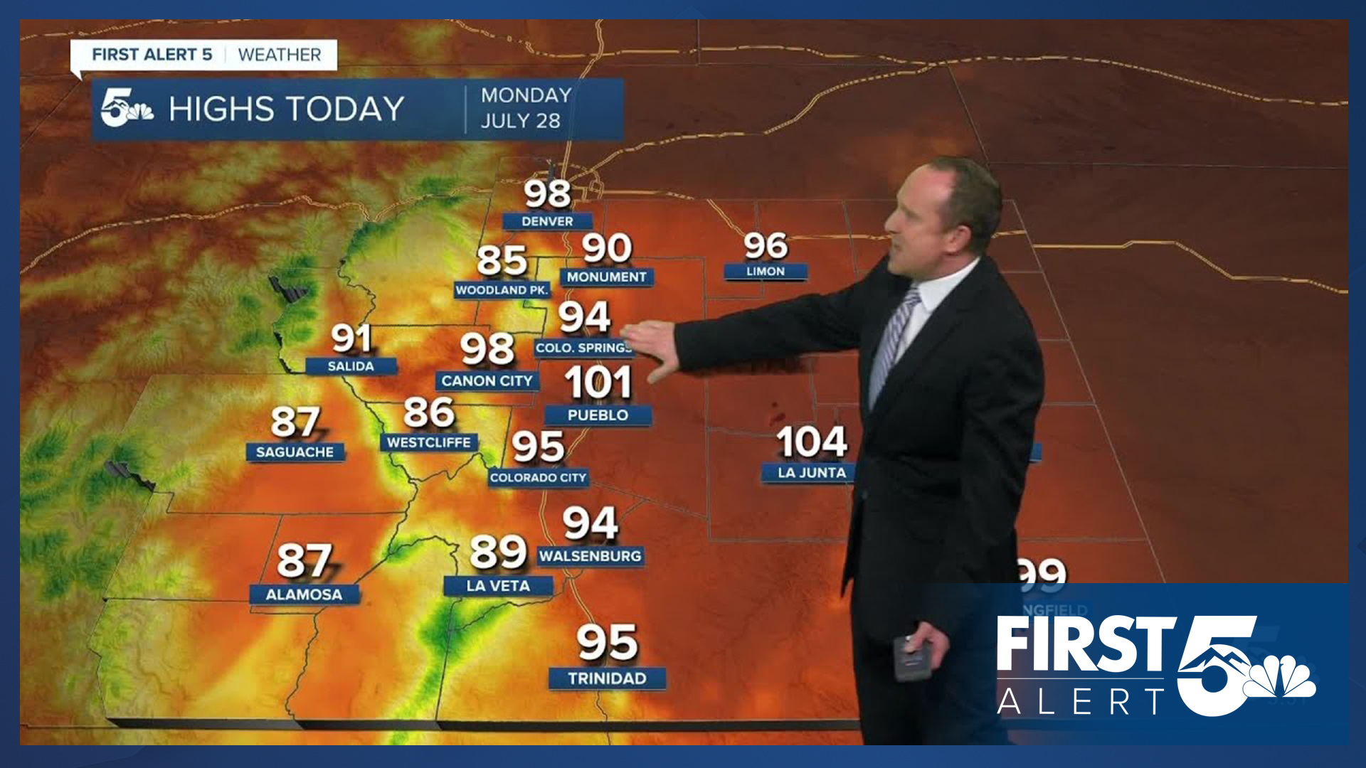
After a hot weekend in the 90s and 100s, the heat isn't going away on Monday. Temperatures across Southern Colorado may even be another degree or two hotter than what we saw yesterday. Our high in Colorado Springs is expected to top out at 94 degrees, with a high of 101 this afternoon in Pueblo.
Moisture will begin to increase across the state today, bringing back the potential for a few isolated thunderstorms into the mountains. Outside of the mountains, some heavier showers may move through the San Luis Valley and Raton Mesa region, with dry skies on the eastern Plains. A few sprinkles could reach the Pikes Peak Region as well.
Colorado Springs forecast: High: 94; Low: 62. With a high of 94 degrees today, this should be our hottest day of the heat wave. Our average high this time of the year is 86 degrees, with today's record high sitting at 96 (1978).
Pueblo forecast: High: 101; Low: 63. After hitting triple digits on Sunday for the fourth time this month in Pueblo, we look to do it again on Monday, with today's high expected to top out at 101 degrees. Current record: 103 (2016)
Canon City forecast: High: 98; Low: 66. Mostly sunny skies this morning will give way to partly to mostly cloudy skies and a hot afternoon. Showers will be possible in the mountains to our west this afternoon, with generally dry skies for Canon City.
Woodland Park forecast: High: 85; Low: 53. While cooler than the Plains, Monday's highs will be well above average across Teller County. Clouds this afternoon will be more present than this past weekend, with about a 20% chance of a shower in Woodland Park.
Tri-Lakes forecast: High: 80s/90s; Low: 50s/60s. The heat that we saw this past weekend will continue, with above average temperatures on Monday and mainly dry skies along and near the Palmer Divide.
Plains forecast: High: 90s/100s; Low: 60s. Highs on Monday will be another degree or two hotter than this past weekend, with widespread triple digits and upper 90s expected on the High Plains.
Walsenburg and Trinidad forecast: High: 80s/90s; Low: 50s/60s. While most of the region will stay dry on Monday, areas south of Highway 50 will see the potential for scattered thunderstorms this afternoon and evening. Heavy downpours will be possible for areas closest to the Colorado-New Mexico border.
Mountains forecast: High: 70s/80s; Low: 40s/50s. Warm, with increasing clouds this morning and the potential for scattered thunderstorms by the afternoon. Any threats of flooding today should be fairly minimal, with the exception of the southern Sangres.
Extended outlook forecast:
The monsoonal moisture plume will increase towards the mid week period, prompting some wetter changes to our forecast. On Tuesday, highs will cool from the middle 90s in Colorado Springs down to the upper 80s. With increasing dew points, this will allow for the potential for hit or miss thunderstorms. Storms could reach Colorado Springs before the lunch hour.
An incoming cold front on Wednesday will cool highs down to the upper 70s and 80s on the Plains through the end of the week while also bringing the potential for heavy rain and flooding to much of Southern Colorado. Across the state, our wettest days look to be on both Wednesday and Thursday, with storms becoming more spotty towards the upcoming weekend.
____
Curious about the First Alert 5 Weather Storm Impact Scale? Check out our cheatsheet explainer.
Watch KOAA News5 on your time, anytime with our free streaming app available for your Roku, FireTV, AppleTV and Android TV. Just search KOAA News5, download and start watching.
