

Today’s Forecast:
After a beautiful week and a warm Thursday, temperatures will soar into the 80s and 90s on the Plains today as high pressure strengthens over the southern Plains. Highs in the mountains and mountain valleys on Friday will range from the upper 60s to the lower 80s.
Today's warmth will also be fueled by strengthening downslope winds. Southwesterly wind gusts could approach 30 mph in the Pikes Peak Region today, with stronger gusts than that for the mountains, mountain valleys, and far eastern Plains. Rain or snow is not expected here locally for the next 24 hours.
Colorado Springs forecast: High: 85; Low: 54. Friday will be very warm and breezy in the Pikes Peak Region, with peak gusts in the 20-30 mph range. The strongest gusts can be expected during the afternoon and early evening hours.
Pueblo forecast: High: 91; Low: 55. Friday will be hot and breezy in Pueblo, with today's high of 91 degrees expected to come fairly close to the current record of 94 degrees, which dates back to 2018.
Canon City forecast: High: 88; Low: 57. Early October heat on Friday will be followed by a windy and warm day on Saturday. Highs over the next few afternoons will warm into the 80s.
Woodland Park forecast: High: 75; Low: 46: The work week will end on a warm and breezy note ahead of more significant changes this weekend. These will include strong wind, a chance for showers, and a big drop in temperatures.
Tri-Lakes forecast: High: 70s/80s; Low: 40s/50s. After some gorgeous weather earlier this week, Friday will bring unseasonably warm temperatures and increasing southwest winds to our forecast, with peak gusts today up around 25-30 mph.
Plains forecast: High: 80s/90s; Low: 50s/60s. Friday will be a scorcher for the Plains for early October, with highs in the middle 90s across the lower Arkansas River Valley. It will also be windy here today and tonight, with southwest wind gusts to 35 mph.
Walsenburg and Trinidad forecast: High: 80s; Low: 50s. Increasing wind will drive temperatures up on Friday, with highs soaring into the 80s this afternoon. Wind gusts later this afternoon and evening could top 30-40 mph in Las Animas County.
Mountains forecast: High: 60s/70s; Low: 30s/40s. After a relatively quiet start to our Friday, southwesterly winds will increase significant during the day today and on Saturday. Peak gusts today could top 35 mph, with gusts later tonight approaching 45 mph in some areas.
Extended outlook forecast:
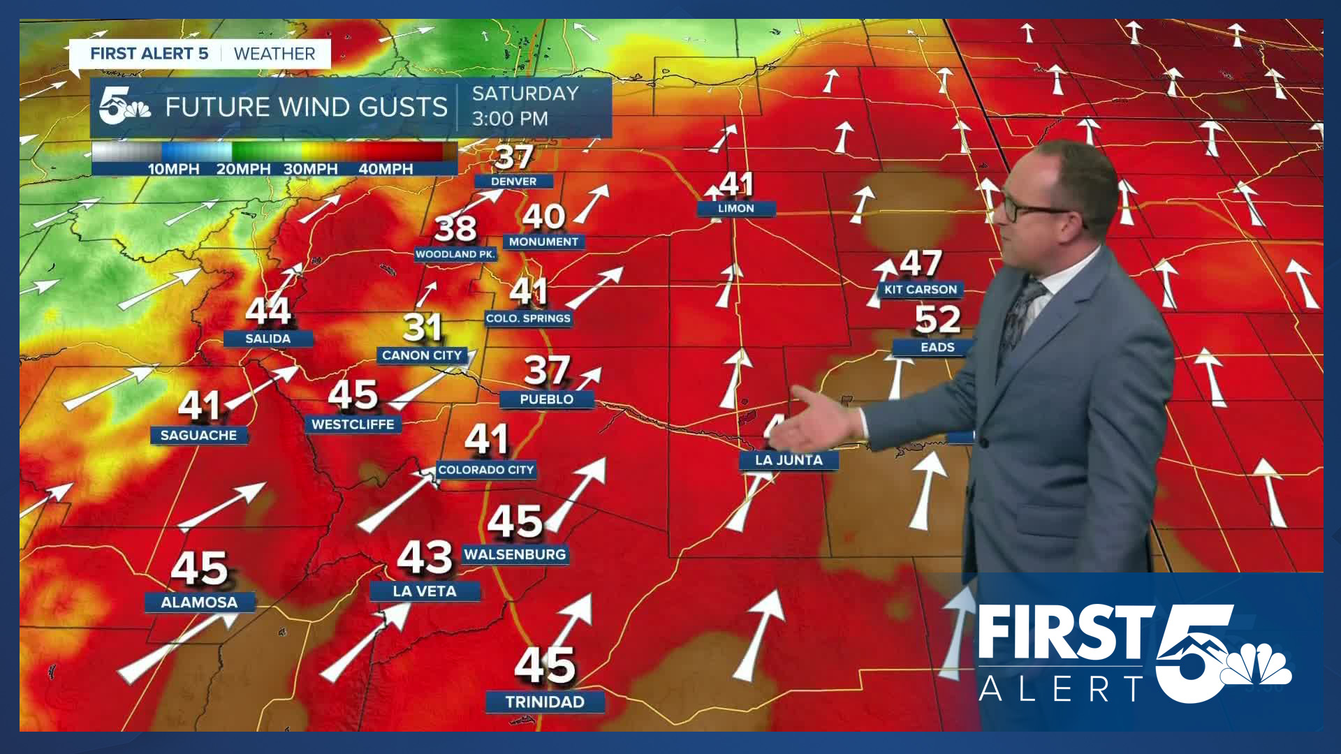
A strong area of low pressure will move from California to Utah on Saturday. This will help to significantly strengthen the southwest flow over Colorado, and Saturday will be windy! Peak gusts in the Springs could top 40 mph, with even stronger gusts in the Plains and across the mountains. We're also tracking a strong cold front Saturday evening. As it blows in from the west, some quick passing showers will be possible from the foothills into the Plains.
Sunday looks dry and mellow, with a more seasonable high in the upper 60s for Colorado Springs. Further cooling will follow on Monday, with a high in the lower 60s. Cool and unsettled weather will continue towards the middle of next week, with a chance for showers both Tuesday and Wednesday.
____
Curious about the First Alert 5 Weather Storm Impact Scale? Check out our cheatsheet explainer.
Watch KOAA News5 on your time, anytime with our free streaming app available for your Roku, FireTV, AppleTV and Android TV. Just search KOAA News5, download and start watching.
