

Today’s Forecast:
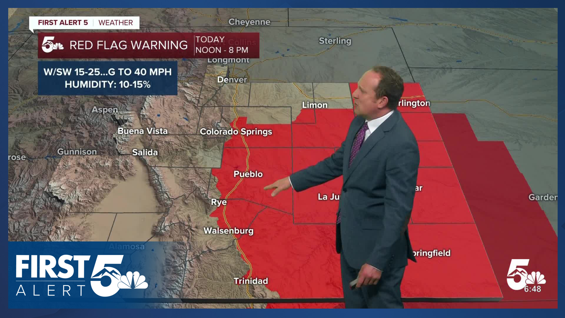
After a couple of cooler days, Thursday's forecast will feature a return to above average temperatures and strong downslope wind. As the wind picks up early this afternoon, relative humidity will fall into the teens. In spite of rain on Wednesday, fire danger will increase, with a Red Flag Warning in effect from noon to 8 pm. W/SW wind gusts will range between 30-40 mph for most areas, but could be stronger than that into the San Luis Valley and southern I-25 corridor.
Daytime highs today will be around 10-15 degrees above average. We'll see 60s and 70s on the Plains, with a mix of 50s and 60s into the mountain valleys.
Colorado Springs forecast: High: 71; Low: 35. Following rain and cooler weather on Wednesday, today's forecast will bring a return to more wind, low humidity, warm temperatures and high fire danger. A Red Flag Warning will remain in effect today from noon to 8 pm.
Pueblo forecast: High: 77; Low: 36. Thursday's forecast will turn windy and warmer, with a Red Flag Warning in effect from noon to 8 pm. Wind gusts in the Pueblo area this afternoon could top 35 mph.
Canon City forecast: High: 74; Low: 41. Thursday will turn breezy to gusty, and warm. Fremont County has not been included in today's Red Flag Warning, but has been included in tomorrow's Fire Weather Watch.
Woodland Park forecast: High: 60; Low: 27. After rain and snow showers on Wednesday in Teller County, today will be dry and warmer, with peak afternoon wind gusts up near 40 mph.
Tri-Lakes forecast: High: 60s/70s; Low: 20s/30s. Our forecast late this week will feature gusty winds, dry skies and some pretty wild temperature swings. Highs today will warm into the 60s and very low 70s. Highs tomorrow will only warm into the upper 40s and 50s.
Plains forecast: High: 70s/80s; Low: 30s/40s. Warm, dry and windy weather will replace the past few days of unsettled weather. With gusts to 40 mph, a Red Flag Warning will remain in effect from noon to 8 pm.
Walsenburg and Trinidad forecast: High: 60s/70s; Low: 30s/40s. Hold onto your hats today, especially in Huerfano County, where peak gusts could top 55 mph in some areas. Due to the combination of high wind and low relative humidity, a Red Flag Warning will remain in effect today from noon to 8 pm.
Mountains forecast: High: 40s/50s; Low: 20s/30s. Windy, bright and dry for our state's southeastern mountain ranges on Thursday. Gusts today will peak at around 45-55 mph.
Extended outlook forecast:
An early morning cold front will cool Friday's highs by as much as 15-20 degrees from today. In Colorado Springs, we'll go from the lower 70s today to a high of just 55 degrees on Friday. While a few days ago we were hoping for rain and snow showers from the storm, the latest forecast trends are much drier as the main area of low pressure tracks too far to the north to bring us any impacts in Southern Colorado, other than wind.
Saturday will be breezy and mild. After starting out in the upper 20s Saturday morning, our high in Colorado Springs will warm to near 60 degrees in the afternoon. Sunday will be bright and warmer, topping out in the middle 60s. A return to lower 70s should be expected in Pueblo by Sunday afternoon.
Dry skies will continue until next Monday, followed by a slight chance for showers on Tuesday.
____
Curious about the First Alert 5 Weather Storm Impact Scale? Check out our cheatsheet explainer.
Watch KOAA News5 on your time, anytime with our free streaming app available for your Roku, FireTV, AppleTV and Android TV. Just search KOAA News5, download and start watching.
