


Tonight's Forecast:
After an active day of severe weather, the main threat for severe thunderstorms will significantly decrease between 7-9 pm. A storm coming out of the Great Basin will spread a lot of moisture into the state during the overnight hours, with rain and snow developing after midnight. Snow levels will lower to near 7,500 feet as cold air drops into the region. Precipitation will be heavy at times into Monday morning, with impacts expected for the morning drive to work.
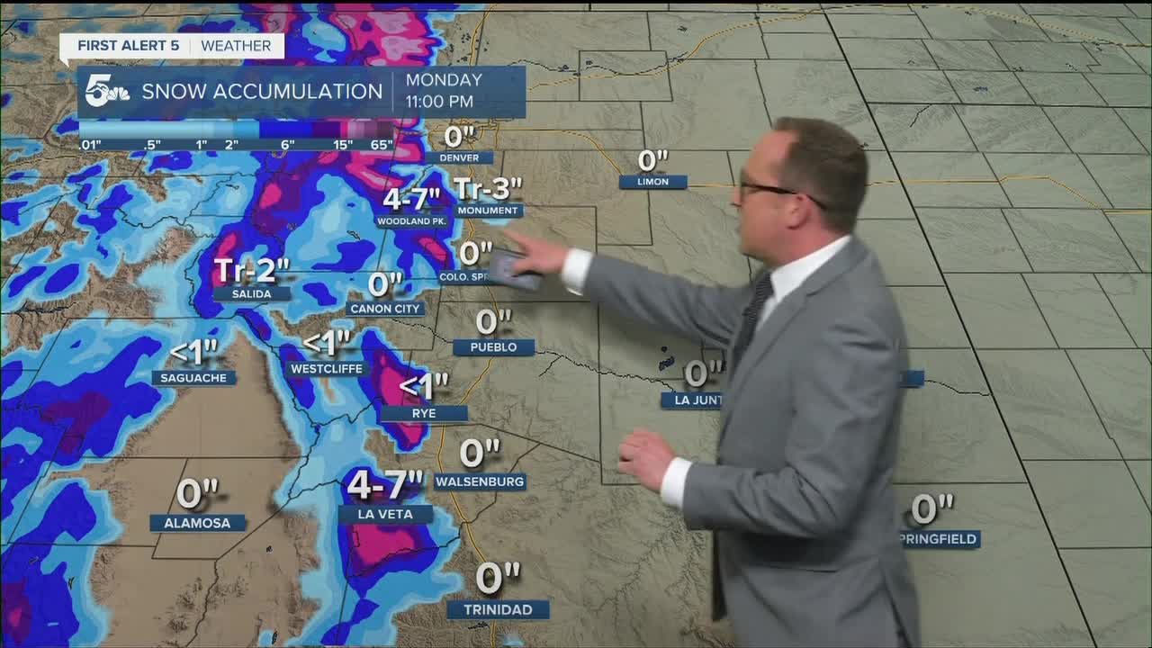
COLORADO SPRINGS: Low: 38; High: 48. A new disturbance coming out of the Great Basin on Monday will bring beneficial moisture to the Pikes Peak Region. Expect a wet and colder day on Monday, with rain showers and isolated thunderstorms for most of the day. Highs will be around 15-20 degrees below average.
PUEBLO: Low: 44; High: 52. After a warm weekend, our weather on Monday will turn rainy and cool. Soaking showers will stick around most of the day, with a isolated thunderstorms also possible.
CANON CITY: Low: 45; High: 51. Chilly on Monday, with periods of rain in the forecast throughout the day. Isolated thunderstorms will be possible, mainly during the afternoon hours.
WOODLAND PARK: Low: 30; High: 38. A changeover from rain to snow is expected during the overnight hours as a storm moves into Southern Colorado from Utah. Heavy snow will be possible through the day on Monday, with 4-7" of accumulation expected.
TRI-LAKES: Low: 30s; High: 40s. An incoming storm will bring periods of rain and snow to the forecast on Monday. With snow levels hovering around 7,500 feet, the forecast for accumulations will be tricky. Parts of the Tri-Lakes could pick up an inch or two of heavy, wet snow.
PLAINS: Low: 40s; High: 50s. The thunderstorm threat will wind down across the Plains between 7-9 pm. We should see some drier air during the overnight hours, but it won't last long as our next storm brings areas of rain and isolated thunderstorms to the forecast on Monday.
WALSENBURG/TRINIDAD: Low: 30s/40S; High: 40s. Monday's forecast will be rainy and cold. Periods of rain can be expected throughout the day, along with the chance for isolated afternoon thunderstorms.
MOUNTAINS: Low: 10s/20s; High: 20s/30s. Monday will be a snowy mess across the higher elevations. A Winter Storm Warning has been issued for the Wet Mountains and Rampart Range near Pikes Peak. As much as 10-18" of snow could fall in these areas. A Winter Weather Advisory has been issued for Teller County and the Sangre de Cristo Range, with the potential for 6-14" of snow to fall here.

Extended Outlook:
A large trough of low pressure will linger over the state through the middle of the week. This will help maintain the chance for afternoon and evening thunderstorms through Wednesday. Following that, we'll see a return of dry and warmer weather late this week as highs return to the 70s and 80s across the Plains.
KOAA News5 on your time, streaming on your Roku, FireTV, AppleTV and AndroidTV.
News5 App | First Alert 5 Weather App | Youtube | Facebook | Instagram | Twitter
