

Tonight's Forecast:
A HEAT ADVISORY is in effect from 11 am until 8 pm on Friday. Avoid strenuous activity outdoors and stay hydrated. Heat-related illness will be a higher risk with high temperatures in the mid-90s to 100s.

A RED FLAG WARNING is in effect from 11 am until 8 pm for the San Luis Valley and Fremont County and much of the Colorado mountains.

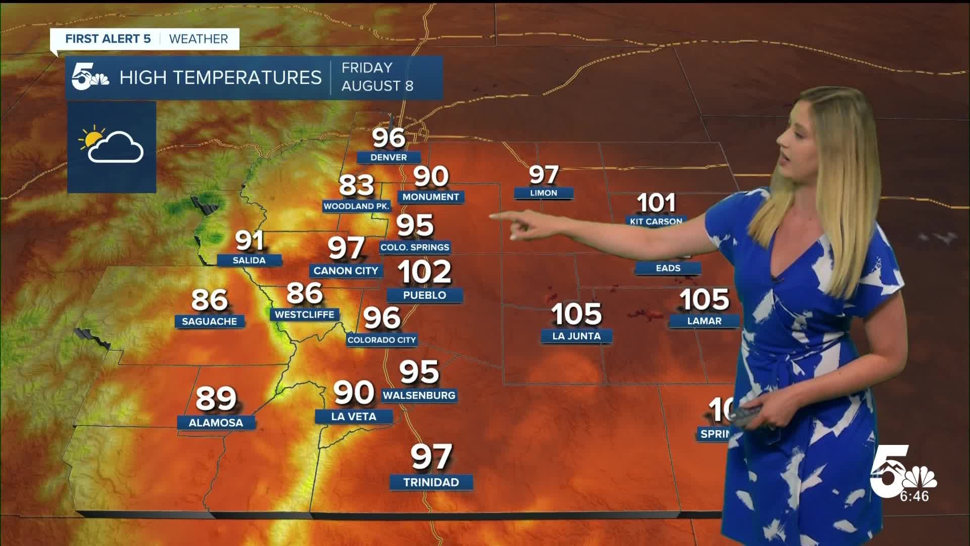
Colorado Springs forecast: Low: 62; High: 95;
HEAT ADVISORY in effect from 11 am until 8 pm. The daily high temperature record is 96 from 1969. Beyond the heat, the morning and evening will be comfortable. The day will be partly cloudy with breezy wind out of the W at 10-15 mph gusting to 30 mph.
Pueblo forecast: Low: 64; High: 102;
HEAT ADVISORY in effect from 11 am until 8 pm. The daily record high on Friday is 104 from 1969. It will be partly cloudy with W wind at 10-15 mph gusting to 25 mph.
Canon City forecast: Low: 66; High: 97;
HEAT ADVISORY in effect from 11 am until 8 pm. RED FLAG WARNING from 11 am until 8 pm. It will be hot and gusty with W wind at 15 mph gusting to 35 mph.
Woodland Park forecast: Low: 54; High: 83;
Warm and breezy on Friday with a partly cloudy sky and W wind at 10-15 mph gusting to 35 mph.
Tri-Lakes forecast: Low: 61; High: 90;
HEAT ADVISORY in effect from 11 am until 8 pm. It will be hot and breezy on Friday with W wind at 10-15 mph gusting to 30 mph.
Plains forecast: Low: 60s; High: 90s-100s;
HEAT ADVISORY in effect from 11 am until 8 pm for Crowley, Otero, Bent, and Prowers County. It will be mostly sunny to partly cloudy on Friday with W wind at 10-15 mph gusting to 25 mph.
Walsenburg and Trinidad forecast: Low: 64/63; High: 95/97;
A hot and gusty day with W wind at 15 mph gusting to 30 mph.
Mountains forecast: Low: 40s-50s; High: 80s-90s;
RED FLAG WARNING from 11 am until 8 pm for the San Luis Valley and the upper Arkansas River zone. The mountain valleys will be very warm and quite gusty with W wind at 10-20 mph gusting 30-40 mph.
Extended outlook forecast:
A cold front arrives on Friday night, which will cool us to the 70s and 80s this weekend with an afternoon thunderstorm chance both Saturday and Sunday.
____
Curious about the First Alert 5 Weather Storm Impact Scale? Check out our cheatsheet explainer.
Watch KOAA News5 on your time, anytime with our free streaming app available for your Roku, FireTV, AppleTV and Android TV. Just search KOAA News5, download and start watching.
