

Today’s Forecast:
The North American Monsoon is returning - a wind pattern change driven by low pressure near southern California, and high pressure in the central US - resulting in a southerly airflow across the Centennial State and pulling in sub-tropical moisture.
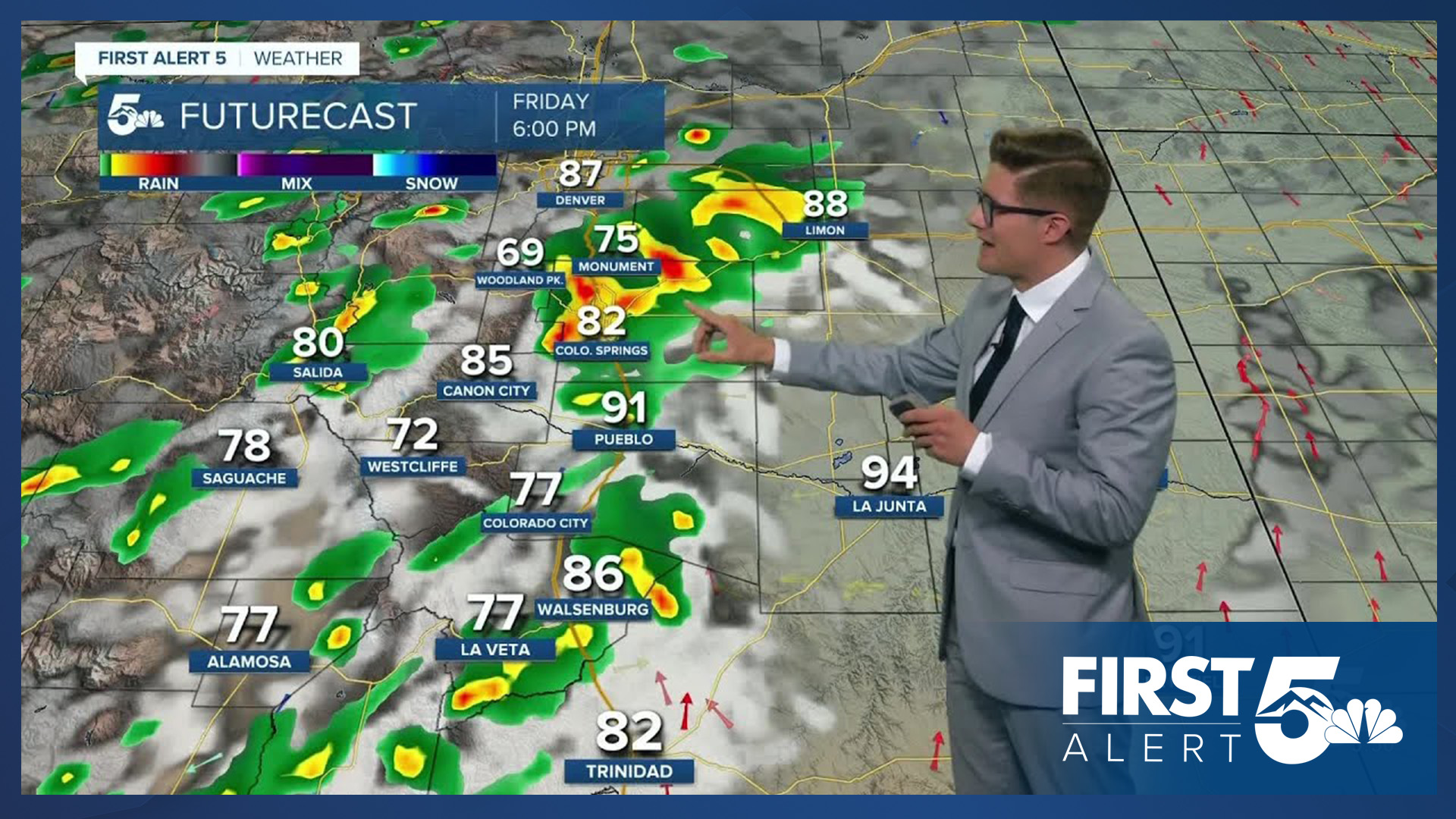
In southern Colorado, the day starts with clear skies, temperatures warm up fast. Clouds increase during the lunch hour on I-25 as storms begin to build in the mountains with the plains remaining clear. Eventually those storms move off the mountains, into I-25, and we see hit-or-miss storms through the middle and late afternoon. Those of us that do get a storm are likely to see gusty winds - with 50-55 mph gusts likely, and a few storms capable of stronger gusts when water evaporates into the air below.
Otherwise, you'll notice haze from wildfire smoke, heavy at times in both the Springs and Pueblo regions into the afternoon. It should get thinner tonight. It's also thinner the further east you go away from the mountains.
Colorado Springs forecast: High: 88; Low: 61.
Mostly sunny throughout the morning. Increasing clouds this afternoon. Isolated afternoon thunderstorms. If you get one, it will be capable of producing gusty winds. Highs back to normal, with winds out of the northwest in the AM, northeast in the PM, at 5-10 mph throughout the day.
Pueblo forecast: High: 96; Low: 63.
Mostly sunny - and seasonally hot - today in the steel city. You'll see the clouds building off to your west in the Wet Mountains early in the afternoon. Isolated hit-or-miss storms are possible this afternoon. West winds at 5-10 mph this morning, shifting northeast at 5-10 mph this afternoon.
Canon City forecast: High: 92; Low: 65.
Mostly sunny through the morning with clouds building up over the mountains by 12 PM. Storms will be widespread off to the west, with a good chance for one of them to move over the city during the afternoon. Northwest winds at 10-15 mph shifting southwest in the afternoon.
Woodland Park forecast: High: 77; Low: 49.
A few high clouds in the morning, otherwise sunny. Clouds increase by late morning as storms begin to build. Scattered thunderstorms during the afternoon. Skies will be hazy due to wildfire smoke. Northwest winds at 5-10 mph.
Tri-Lakes forecast: High: 80s; Low: 50s.
Mostly sunny this morning, increasing clouds this afternoon with isolated afternoon thunderstorms. North winds at 5-10 mph.
Plains forecast: High: 90s; Low: 60s.
Sunny and hot. South winds at 10-15 mph. Mainly dry today.
Walsenburg and Trinidad forecast: High: 88; Low: 62/60.
Mostly sunny this morning, scattered afternoon thunderstorms. Northwest winds at 10-15 mph.
Mountains forecast: High: 70s/80s; Low: 50s.
Mostly sunny through 10AM, then increasing clouds with widespread storms. Northwest winds at 5-10 mph, shifting west this afternoon.
Extended outlook forecast:
A rinse-and-repeat pattern is the picture with the North American Monsoon the main pattern throughout the weekend. Expect to see scattered mountain thunderstorms both Saturday and Sunday, with isolated storms along I-25. Highs will remain in the upper 80s with sunny mornings and cloudier afternoons. Storm coverage will be relatively higher Saturday due to weak passing upper level energy.
We'll be mainly dry Monday with only a spotty storm chance on Tuesday, both days reaching the 90s. Increasing moisture Wednesday brings storm chances back, ahead of our next cold front.
____
Curious about the First Alert 5 Weather Storm Impact Scale? Check out our cheatsheet explainer.
Watch KOAA News5 on your time, anytime with our free streaming app available for your Roku, FireTV, AppleTV and Android TV. Just search KOAA News5, download and start watching.
