

Tonight's Forecast:
Overnight will be mild and pretty humid. Low clouds and patchy fog are possible in the plains.
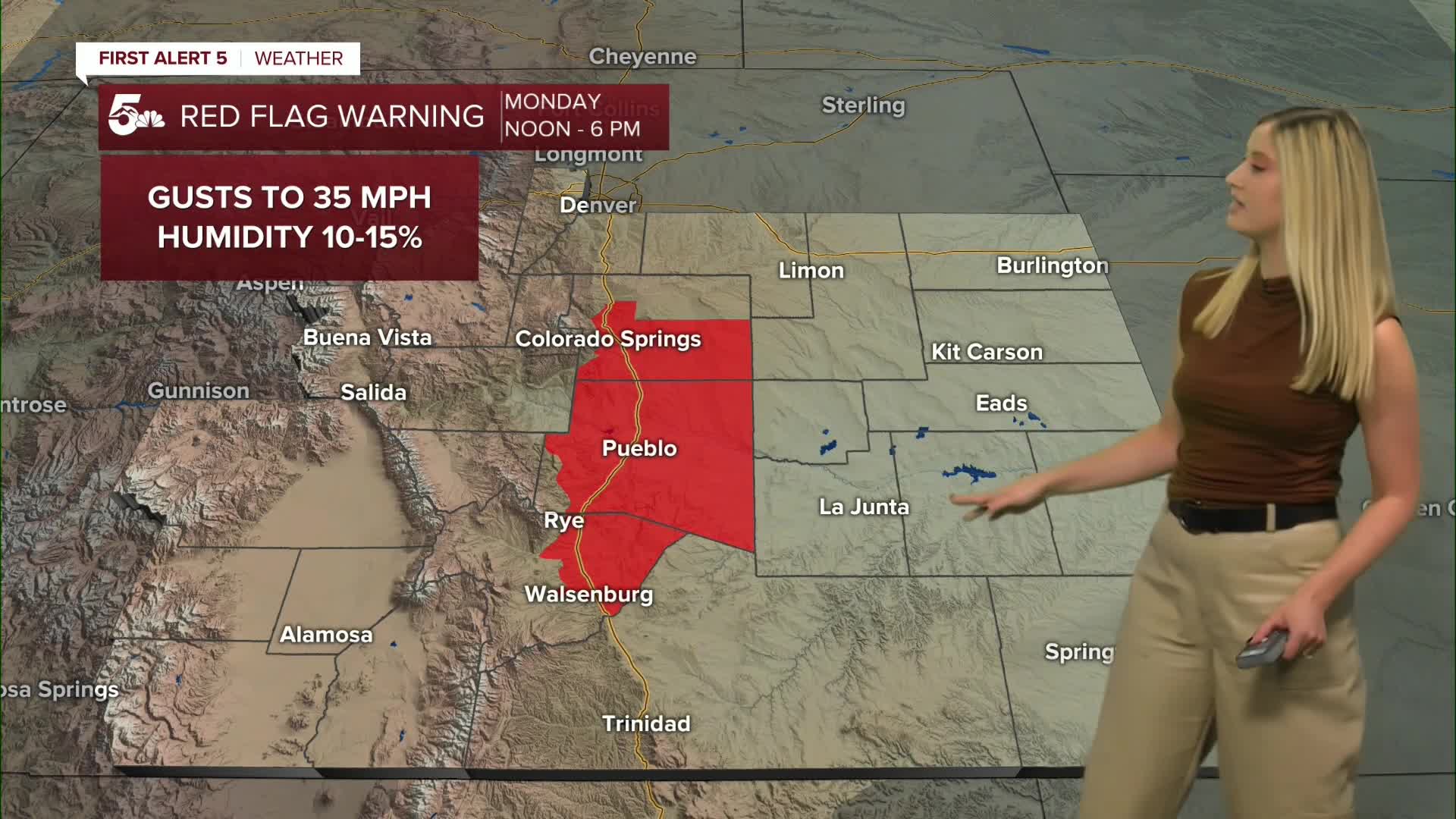
Monday Red Flag Warning:
After the humid morning, we dry out quickly with downsloping westerly wind. This will make for a warm Monday, but it will also be dry and gusty. A RED FLAG WARNING goes into effect at noon and expires at 6 pm.

Colorado Springs forecast: Low: 38; High: 70;
A RED FLAG WARNING is in effect from noon until 6 pm. Wind will be out of the W during the day at 10 mph gusting to 35 mph. It will turn out of the N in the evening as a cold front blows through.
Pueblo forecast: Low: 37; High: 75;
A RED FLAG WARNING is in effect from noon until 6 pm. Low clouds and patchy fog are possible in the morning, before quickly clearing with sunshine for most of the day. Wind will be out of the W at 10-15 mph, gusting to 35 mph.
Canon City forecast: Low: 44; High: 73;
Mostly sunny, dry, and windy on Monday. Wind will be out of the W at 15 mph gusting to 40 mph.
Woodland Park forecast: Low: 35; High: 60;
Monday will be sunny and cool with windy conditions. Wind will be out of the W at 15-10 mph gusting to 40 mph.
Tri-Lakes forecast: Low: 41; High: 64;
Monday will be mild and sunny, but windy. Wind will be out of the W during the day and out of the N in the evening. It will be sustained at 10-15 mph, gusting to 35 mph.
Plains forecast: Low: 30s-40s; High: 70s;
Starting with low clouds and patchy fog, then the afternoon will be sunny. Wind will be out of the W at 5-10 mph, gusting to 30 mph.
Walsenburg and Trinidad forecast: Low: 46/47; High: 70/74;
A RED FLAG WARNING is in effect from noon until 6 pm for the Walsenburg vicinity. Wind will be out of the W at 10-15 mph, gusting to 35 mph.
Mountains forecast: Low: 30s-40s; High: 60s;
The mountain valleys will be windy on Monday. Westerly wind will be sustained from 10-20 mph, gusting 30-40 mph.
Extended outlook forecast:
Tuesday will be over 20 degrees cooler behind a cold front that blows through on Monday evening. The high will only make it to the 40s and 50s. Temperatures will fall to the 20s overnight for several days. It will take some time for temperatures to rebound after this cold snap. Highs will be rising to the 50s and 60s Wednesday through Friday.
For Halloween, plan on a cool and breezy day in the 50s and 60s. Then temperatures will fall to the low 40s for trick-or-treating.
____
Curious about the First Alert 5 Weather Storm Impact Scale? Check out our cheatsheet explainer.
Watch KOAA News5 on your time, anytime with our free streaming app available for your Roku, FireTV, AppleTV and Android TV. Just search KOAA News5, download and start watching.
