

Today’s Forecast:
After the warmest Christmas on record for Colorado Springs and Pueblo, temperatures will cool off by around 6-10 degrees from yesterday. Even though we'll be cooler than Christmas Day, highs will still be as much as 15-20 degrees above average for this time of the year. Temperatures will warm into the 60s and lower 70s on the Plains, with 40s and 50s in the mountain valleys.
W/SW wind will be gusty in the high country on Friday, with breezy to gusty conditions also expected this afternoon on the Plains. Dry skies can be expected for most of the state today, followed by an increase in snowfall for the high country starting late tonight, continuing into Saturday.
Colorado Springs forecast: High: 62; Low: 35. After hitting the 70s for the third time this month on Christmas Day, highs on Friday will cool back down to the lower 60s. W/SW wind gusts of 20-30 mph will be possible this afternoon.
Pueblo forecast: High: 66; Low: 32. After warming into the middle 70s on Christmas Day, highs will cool off modestly today to the middle 60s. Temperatures tonight will be chilly, dropping down to the lower 30s.
Canon City forecast: High: 64; Low: 40. Mild highs and bright skies during the day will give way to increasing clouds this evening ahead of a big shift to our weather pattern this weekend.
Woodland Park forecast: High: 55; Low: 31. Friday's forecast will be mild and gusty, with our high today climbing into the middle 50s. Peak gusts this afternoon in Teller County could top 40 mph in some areas.
Tri-Lakes forecast: High: 50s/60s; Low: 30s. Friday will be another unseasonably mild day, with breezy southwest winds driving temperatures into the upper 50s and lower 60s this afternoon.
Plains forecast: High: 60s/70s; Low: 30s/40s. While it won't be as warm as yesterday, today's highs in the 60s and lower 70s will continue with the familiar trend of above average temperatures that we've seen so many times in the month of December.
Walsenburg and Trinidad forecast: High: 60s; Low: 30s/40s. Breezy and mild weather will continue on Friday as we look to wrap up the week with afternoon highs that will be around 15-20 degrees above average. Peak gusts today to 35 mph.
Mountains forecast: High: 40s; Low: 20s/30s. Our forecast will be dry and gusty on Friday, with temperatures this afternoon warming into the 40s. Southwest wind gusts to 40 mph will increase to as strong as 50-55 mph in the mountains tonight and Saturday.
Extended outlook forecast:
Saturday will be dry in the Pikes Peak Region, with temperatures warming into the upper 50s. Highs will be in the lower 60s in Pueblo and Canon City. It will also be windier than today, with gusts to 35 mph on the I-25 corridor and stronger gusts in the mountains and foothills.
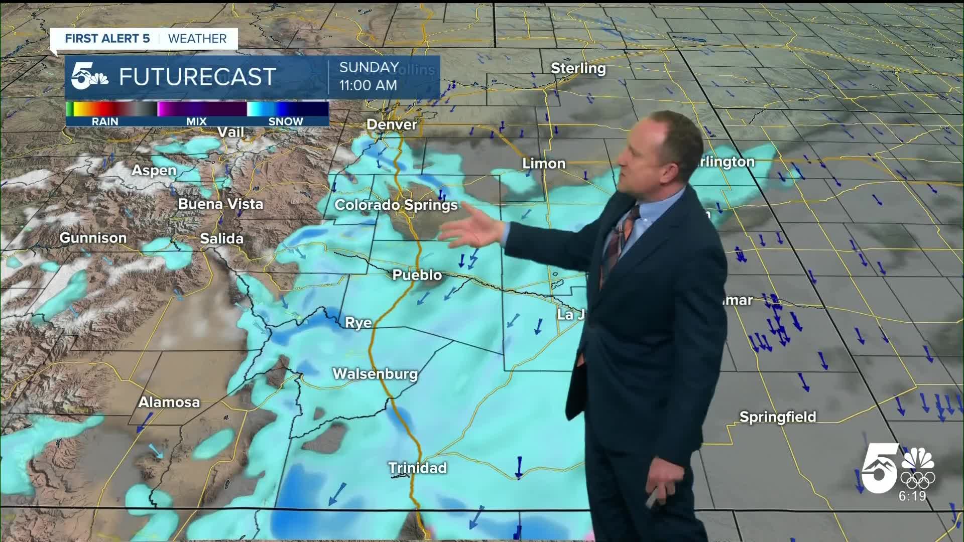
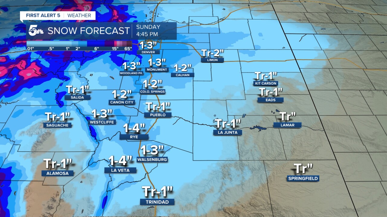
On Sunday, a strong cold front will arrive. This will bring us a quick burst of snow during the morning and early afternoon hours. It will also be windy and colder on Sunday, with strong northerly wind gusts to 40 mph, which could impact visibility at times during periods of heavy snow. Highs on Sunday will only warm into the 20s and 30s. Current snowfall projections are in the 1-2" range for Colorado Springs and Canon City, with 1-3" for Monument Hill. Isolated amounts to 4" will be possible for northern El Paso County and Teller County.
Lows in the teens can be expected Monday morning across the Plains, with the cold air lingering Monday afternoon into Monday night. Highs will rebound back into the 50s by next Tuesday, with dry skies into the start of 2026.
____
Curious about the First Alert 5 Weather Storm Impact Scale? Check out our cheatsheet explainer.
Watch KOAA News5 on your time, anytime with our free streaming app available for your Roku, FireTV, AppleTV and Android TV. Just search KOAA News5, download and start watching.
