


Today’s Forecast:
Get outside today if you can. High pressure will briefly build into the southeastern quadrant of Colorado today, leading to sunshine and a return to mild highs in the upper 50s to low 60s. Winds will be light this morning from the west, shifting southeast this afternoon and becoming slightly more noticeable at 10-15 mph. A band of high cirrus clouds will steam overhead late in the afternoon, which is associated with our next incoming storm system.
Colorado Springs forecast: High: 58; Low: 32.
Sunny and mild with northwest winds in the AM, turning southeast this afternoon.
Pueblo forecast: High: 62; Low: 30.
Fog clearing out, with west winds this morning turning east this afternoon, relatively light, at 5-10 mph. A comfortable day.
Canon City forecast: High: 60; Low: 33.
Sunny and quiet - west morning winds shifting east this afternoon, at 5-10 mph.
Woodland Park forecast: High: 51; Low: 25.
Sunny with west winds at 5-10 mph shifting south in the afternoon.
Tri-Lakes forecast: High: 50s; Low: 20s.
Sunny with northeast winds at 5-10 mph, shifting southeast in the afternoon.
Plains forecast: High: 60s; Low: 20s.
Mostly sunny with northwest winds at 10-15 mph.
Walsenburg and Trinidad forecast: High: 58/62; Low: 32.
Sunny with west winds at 5-10 mph shifting east at 5-10 mph this afternoon.
Mountains forecast: High: 50s; Low: 20s.
Sunny - northwest winds at 5-10 mph, becoming variable in the afternoon.
Extended outlook forecast:
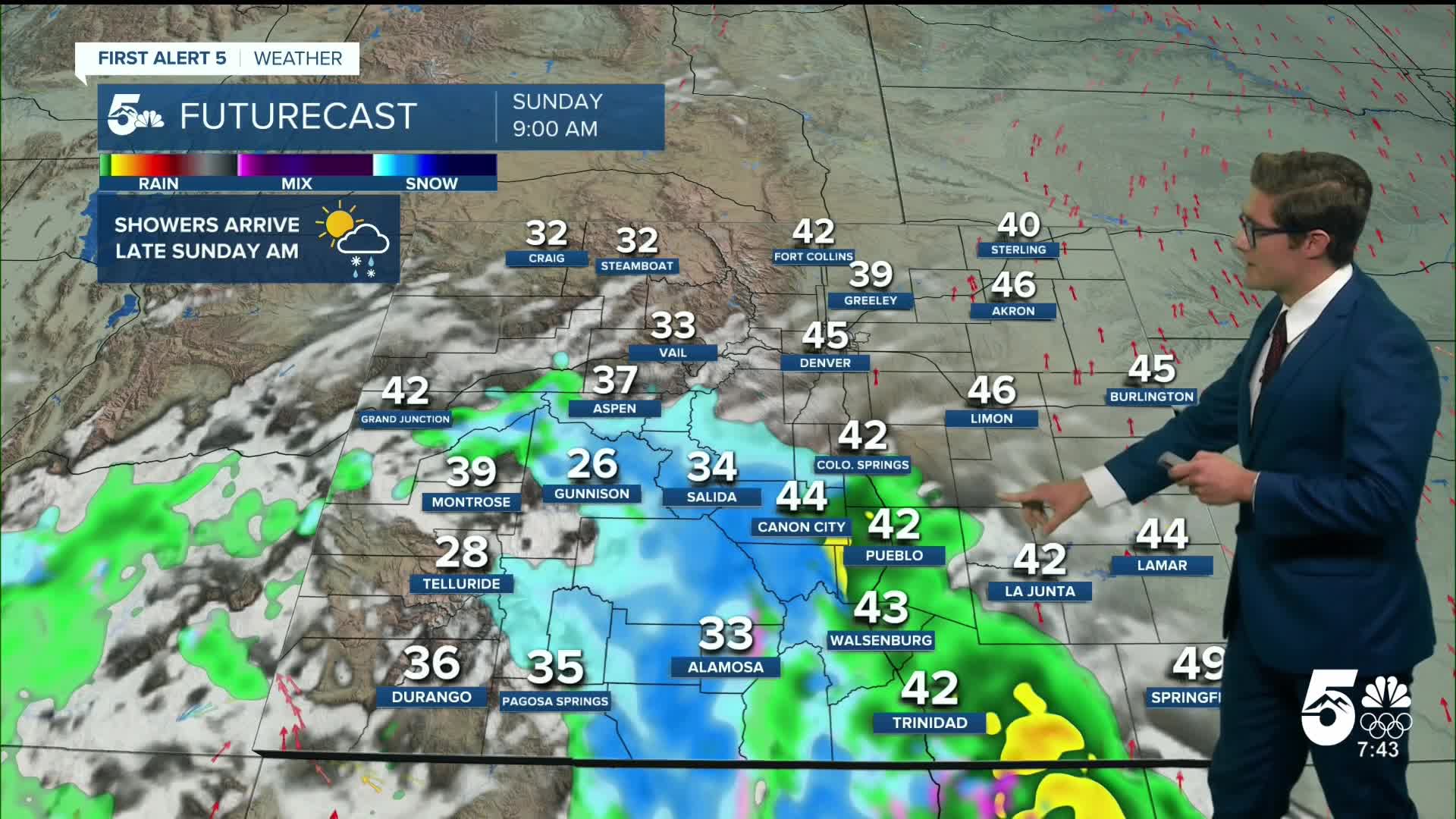
Tonight begins mainly clear, turning mostly cloudy by morning. Another closed low, pacific-origin storm system will track toward Colorado Sunday. Moisture and lift ahead of the low will bring a band of rain through the plains of southern Colorado in the morning. Showers are likely along I-25, with snow again in the mountains. A lull in activity is possible over the plains in the afternoon. As the low continues moving through Colorado, we'll see some wrap around precipitation on Sunday evening. Depending on timing, this will lead to a wintry mix in the Pikes Peak Region, with the potential for a bit of snow over the Palmer Divide.
Monday itself will be warmer, briefly. A cold front arrives Tuesday leading to a large temperature drop and a chilly afternoon. Highs will be in the 30s and 40s. The front brings in Canadian air, resulting in lows plummeting down to the 20s and teens. Wednesday is still cool with that air mass slowly departing and slightly warmer than Tuesday- with highs in the 40s and 50s. Then, we trend back to average by Thanksgiving.
____
Curious about the First Alert 5 Weather Storm Impact Scale? Check out our cheatsheet explainer.
Watch KOAA News5 on your time, anytime with our free streaming app available for your Roku, FireTV, AppleTV and Android TV. Just search KOAA News5, download and start watching.
