

Today’s Forecast:
A strong mountain wave is sending more wind down the mountain slopes this morning, with some areas from the Pikes Peak Region to the Wet Mountain Valley gusting in excess of 40 mph. The wind will weaken over the next few hours, with less wind this afternoon compared to the past few days. Afternoon gusts in the lower elevations will be around 15-25 mph, with gusts 25-35 mph in the higher terrain.
Temperatures today will be slightly cooler than yesterday. We can expect a mix of 50s and 60s on the Plains, with 40s today for Teller County and our mountain valleys.
Colorado Springs forecast: High: 55; Low: 29. Strong downsloping gusts early this morning will weaken towards the lunch hour, with much lighter wind this afternoon compared to what we've seen the past few days. Highs today will be around 10 degrees above average.
Pueblo forecast: High: 60; Low: 24. A windy and cool morning will give way to lighter breezes this afternoon, mild temperatures and plenty of sunshine. Today's high of near 60 degrees will be more than 10 degrees above average.
Canon City forecast: High: 58; Low: 31. Sunshine, mild temperatures and breezy westerly wind will stick around on Tuesday, with highs today well above seasonal averages for early January.
Woodland Park forecast: High: 45; Low: 24. Tuesday will be dry, with mostly sunny skies and breezy west winds. Our highs today in Teller County will warm into the 40s.
Tri-Lakes forecast: High: 40s/50s; Low: 20s/30s. After a windy morning, the wind will weaker this afternoon to around 10-15 mph, with occasional gusts to 25 mph. Skies will be dry today, with temperatures warming into the upper 40s and lower 50s.
Plains forecast: High: 50s/60s; Low: 20s/30s. Although still very dry on Tuesday, weaker wind should keep us out of Red Flag Warning criteria on the High Plains. Temperatures this afternoon will be mild, topping out in the 50s and lower 60s.
Walsenburg and Trinidad forecast: High: 50s; Low: 20s/30s. Windy this morning, with breezy to gusty W/SW wind into the afternoon hours. Today's highs will remain mild, topping out in the 50s in most areas.
Mountains forecast: High: 30s/40s; Low: 10s/20s. Dry skies and gusty winds for our Tuesday will give way to snowy changes late this week. Those changes aren't expected until Wednesday nightor Thursday, so enjoy the sunshine while you still can.
Extended outlook forecast:
Wednesday will bring a calm period of weather to the Pikes Peak Region ahead of late week changes. The wind will be lighter than today, with our high in Colorado Springs expected to top out in the middle to upper 50s. Lower 60s can be expected from Pueblo into the eastern Plains.
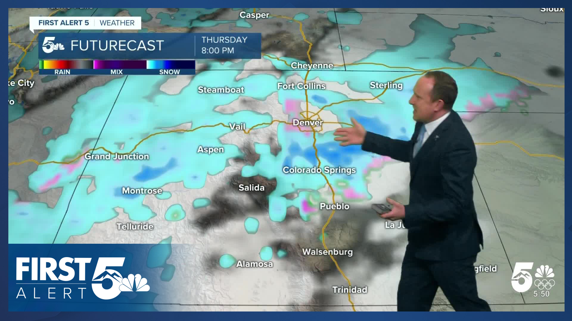
A storm dropping in from the north on Thursday will send a cold front into Southern Colorado. Moisture will increase as the upslope flow builds behind the front. This will set the stage for snow to return! Snow is likely to develop during the day on Thursday before tapering off Friday afternoon. Although it's too early to put out a region-wide snowfall forecast, an early estimate for Colorado Springs is for 2-4" of snow from the storm. As we continue to nail down snow totals late this week, stay tuned for updates from First Alert 5.
____
Curious about the First Alert 5 Weather Storm Impact Scale? Check out our cheatsheet explainer.
Watch KOAA News5 on your time, anytime with our free streaming app available for your Roku, FireTV, AppleTV and Android TV. Just search KOAA News5, download and start watching.
