

Today’s Forecast:
Temperatures have been cool, with quiet weather in place this morning. By the afternoon, increasing NW flow will lead to another healthy boost in temperatures, with highs today soaring into the 80s and 90s across Southern Colorado. Some of the hottest readings will be on the eastern Plains and lower Arkansas River Valley.
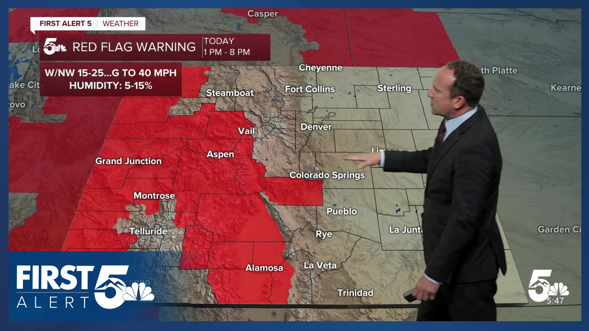
NW wind gusts in Southern Colorado will be around 20-30 mph for most areas, with stronger wind gusts expected across the middle and upper Ark River Valley. A Red Flag Warning will be in effect today for these areas, as well as the San Luis Valley from 1 pm to 8 pm.
Colorado Springs forecast: High: 89; Low: 58. It's hard to believe that just two days ago, temperatures were in the upper 60s. Today's highs will warm into the upper 80s, with our high on Wednesday expected to soar into the upper 90s.
Pueblo forecast: High: 96; Low: 61. Sunny skies, breezy NW winds, and hot highs can be expected on Wednesday. Today's high in the middle 90s will be more than 5 degrees above average.
Canon City forecast: High: 94; Low: 62. After a couple of "cooler" days, the heat will be the big weather story from today into Wednesday. Highs today will warm into the middle 90s followed by triple digits tomorrow.
Woodland Park forecast: High: 80; Low: 52. Warmer than average temperatures can be expected both today and tomorrow, with highs each afternoon topping out in the 80s.
Tri-Lakes forecast: High: 80s; Low: 50s. Summer-like heat can be expected the next couple of afternoons, with highs in the 80s today and the 90s on Wednesdsay.
Plains forecast: High: 90s; Low: 50s/60s. Highs in the 90s this afternoon will help to ease us into the real heat that's on the way tomorrow. Wednesday's highs will crack the triple digits in many areas and should go down as the hottest day of the year so far.
Walsenburg and Trinidad forecast: High: 80s/90s; Low: 50s/60s. Tuesday's forecast will feature sunny skies, breezy W winds and plenty of heat. Our highs today will warm into the upper 80s and 90s. Tomorrow will be even hotter.
Mountains forecast: High: 70s/80s; Low: 40s/50s. It will be a dry, windy and warm day in the mountains on Tuesday, with Red Flag Warnings in effect from 1 pm to 8 pm for the San Luis Valley and much of western Colorado. Gusts in some areas today could top 40 mph.
Extended outlook forecast:
The wind and the heat will be more pronounced on Wednesday. A Heat Advisory has been issued on Wednesday from 11 am to 7 pm for parts of El Paso, Fremont and Pueblo counties. Our high in Colorado Springs is expected to warm to around 97 to 98 degrees, with the current record at COS of 97 degrees certainly in jeopardy. Pueblo and Canon City can expect highs to crack the century mark for the first time this year.
Fire Weather Watches have also been posted on Wednesday for a large part of Southern Colorado, but do not currently include El Paso County. That could change, depending on changes to fuel moisture.
A dry cold front will shave off around 15-20 degrees to our highs on Thursday, which will put us back down to the lower 80s in Colorado Springs. This won't last long as highs look to return to the upper 80s and lower 90s from Friday to Saturday. Chances for rain will increase Sunday to Monday across the Pikes Peak Region.
____
Curious about the First Alert 5 Weather Storm Impact Scale? Check out our cheatsheet explainer.
Watch KOAA News5 on your time, anytime with our free streaming app available for your Roku, FireTV, AppleTV and Android TV. Just search KOAA News5, download and start watching.
