


Tonight's Forecast:
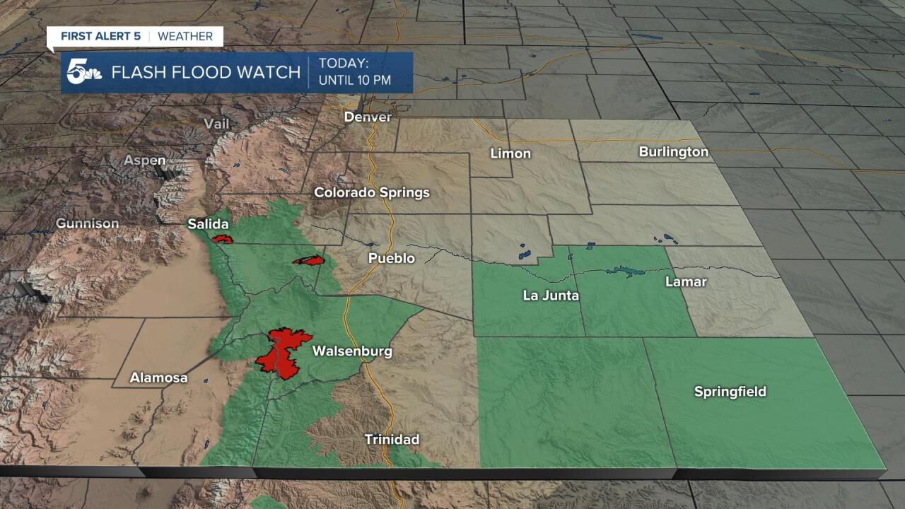
Severe weather threat is winding down across the Pikes Peak Region, but a few isolated severe thunderstorm will still be possible through mid-evening for the southern mountains, mountain valleys and southeast Plains. The other threat will be for flash flooding to occur as storms once again congeal across the Plains. A Flash Flood Watch has been extended to include the following counties: Otero, Bent, Las Animas and Baca. In addition, a Flash Flood Watch also remains in effect until 10 pm for our recent burn scars.
COLORADO SPRINGS: Low: 45; High: 53. Memorial Day will be chilly across the Pikes Peak Region, and still wet. Highs will only warm into the middle 50s as rain and isolated thunderstorms are expected to form after 2 pm.
PUEBLO: Low: 48; High: 59. You'll want to get outside early on Memorial Day, and plan for more rain and isolated thunderstorms by the afternoon. Rain could be heavy at times across Pueblo County.
CANON CITY: Low: 48; High: 57. Much like the weekend, Memorial Day will be wet as showers and isolated thunderstorms activate by the afternoon. In addition to the rain, it will be chilly, with upper 50s for highs.
WOODLAND PARK: Low: 39; High: 48. Memorial Day 2021 will be a cold one this year for Teller County, and wet by the afternoon as that's our best chance for showers and thunderstorms.
TRI-LAKES: Low: 30s/40s; High: 50s. Chilly highs and rainy skies on Monday. If you're looking to enjoy the outdoors, take care of that early before the rain moves in.
PLAINS: Low: 40s/50s; High: 50s. Periods of heavy rain will continue through late this evening, with a Flash Flood Watch in effect until 10 pm. Dry skies early Monday will give way to afternoon showers and thunderstorms.
WALSENBURG/TRINIDAD: Low: 40s; High: 50s. Cool and unsettled on Memorial Day. Make sure that your outdoors plans are early before storms starting popping up.
MOUNTAINS: Low: 20s/30s; High: 30s/40s. Periods of rain, snow and thunderstorms can be expected across the mountains on Monday, with several inches of accumulation for areas above 10,000 feet.
Extended Outlook:
Finally by Tuesday, sunshine will start to return to Southern Colorado as the storm system responsible for the weekend soaker moves away from the state. Lingering moisture will lead to scattered afternoon thunderstorms on Tuesday across the region, with higher elevation storms possible Wednesday. Drier skies and warmer highs are expected by the end of the week, with 80s across the lower elevations.
KOAA News5 on your time, streaming on your Roku, FireTV, AppleTV and AndroidTV.
News5 App | First Alert 5 Weather App | Youtube | Facebook | Instagram | Twitter
