


7:10 p.m. | Storms are becoming more numerous across the Pikes Peak Region this evening. Expect periods of heavy rain, small hail and lots of lightning for the next few hours. Be safe!
6:37 p.m. | A Flash Flood Warning is now in from Cascade south into the west side of Colorado Springs. Heavy runoff and dangerous flooding are either occurring now or are imminent.
Heavy rainfall happening right now in Manitou Springs, with a Flash Flood Warning now in effect. Warning also includes the lower Ute Pass. Heavy runoff and flooding may be occurring in this area! #cowx pic.twitter.com/2zyQqQNOEo
— Alan Rose (@AlanRoseWX) May 18, 2021
6:18 p.m. |Storm cell popping up on the west side of Colorado Springs, extending up through the Ute Pass. Looks like heavy rain and small hail with this one.
Not severe, but we've got a weak hail core (seen in purple) showing up on the west side of Colorado Springs nearby Manitou. Heavy rain and lightning are also present. #cowx pic.twitter.com/77GGawDUJg
— Alan Rose (@AlanRoseWX) May 18, 2021
5:30 p.m. | Flash Flood Warning in effect for the metro Pueblo region until 7:15 p.m. Avoid flooded areas until the water recedes.
Getting drenched right now in Pueblo from this strong storm moving over the area. Watch out for lightning, small hail and very heavy rain. #cowx pic.twitter.com/ElJg6FzWdG
— Alan Rose (@AlanRoseWX) May 17, 2021
5:17 p.m. | Strong storm cell passing directly over the Pueblo area right now. Plenty of lightning present...seek shelter!
Getting drenched right now in Pueblo from this strong storm moving over the area. Watch out for lightning, small hail and very heavy rain. #cowx pic.twitter.com/ElJg6FzWdG
— Alan Rose (@AlanRoseWX) May 17, 2021
4:45 p.m. | Severe Thunderstorm Warning for Pueblo County has been canceled. Hail threat has diminished, but heavy rain is still likely in the Pueblo area after 5 p.m.
4:30 p.m. | Small hail in Penrose
4:18 p.m. | Watching this storm over Penrose closely. Showing signs of rotation, along with dime size hail and very heavy rainfall.
Heads up Pueblo! A Severe Thunderstorm Warning is in effect due to the threat of quarter size hail, 60 mph wind gusts and very heavy rainfall! Expect the storm to hit Pueblo West around 4:30 pm. #cowx pic.twitter.com/2Rn2B1Agkx
— Alan Rose (@AlanRoseWX) May 17, 2021
3:55 p.m. | A Severe Thunderstorm Warning has been issued for the Pueblo area. Main threats will include quarter size hail, very heavy rain and 60 mph wind gusts. Storm is moving in a northeasterly direction at only 15 mph.
Heads up Pueblo! A Severe Thunderstorm Warning is in effect due to the threat of quarter size hail, 60 mph wind gusts and very heavy rainfall! Expect the storm to hit Pueblo West around 4:30 pm. #cowx pic.twitter.com/2Rn2B1Agkx
— Alan Rose (@AlanRoseWX) May 17, 2021
3:43 p.m. | Elevated flash flood risk right now in southwestern Fremont County and the Canon City area. Our weather cams are showing some flooding downtown.
First Severe Thunderstorm Warning of the day for southwestern Las Animas County, including Trinidad. Line of storms is moving west at 10 mph. Main threats: 60 mph gusts and quarter size hail. #cowx pic.twitter.com/HhSO0V3wKE
— Alan Rose (@AlanRoseWX) May 17, 2021
3:05 p.m. | Our first Severe Thunderstorm Warning of the day has been issued for a line of storms over southwestern Las Animas County. Hail right now southwest of Starkville and over Hoehne.
First Severe Thunderstorm Warning of the day for southwestern Las Animas County, including Trinidad. Line of storms is moving west at 10 mph. Main threats: 60 mph gusts and quarter size hail. #cowx pic.twitter.com/HhSO0V3wKE
— Alan Rose (@AlanRoseWX) May 17, 2021
2:45 p.m. | Currently no weather warnings for Canon City, but it's a soaker out there this afternoon.
A heavy line of storms extending from south of Canon City through Rye has generated a Flash Flood Warning for the Junkins Burn Scar. Heavy rainfall rates may trigger mud & debris flows in this area. #cowx pic.twitter.com/YFm1WEG3Qk
— Alan Rose (@AlanRoseWX) May 17, 2021
2:25 p.m. | A line of storms over the Junkins Fire Burn Scar has prompted a Flash Flood Warning for parts of Custer and Pueblo counties until 5:15 p.m. Avoid flooded out areas if/when possible!
A heavy line of storms extending from south of Canon City through Rye has generated a Flash Flood Warning for the Junkins Burn Scar. Heavy rainfall rates may trigger mud & debris flows in this area. #cowx pic.twitter.com/YFm1WEG3Qk
— Alan Rose (@AlanRoseWX) May 17, 2021
2:05 p.m. |Severe Thunderstorm Watch has been issued for the following counties: Pueblo, Crowley, Huerfano, Las Animas, Otero, Bent, Prowers and Baca. Main threats will be isolated large hail, gusty winds, heavy rainfall and isolated tornadoes.
Here we go again! It's the third day in a row with an increased risk of severe weather for the SE Plains and lower portions of the Arkansas River Valley. #cowx pic.twitter.com/U5Wad2qd78
— Alan Rose (@AlanRoseWX) May 17, 2021
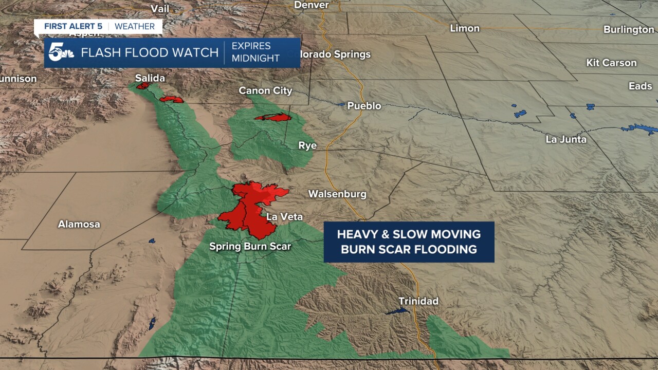
2:00 p.m. | Flash Flood Warning in effect for the Spring Fire Burn Scar until 4:45 p.m. Big Branch and Indian Creek should be prepared for possible debris flows.
Heavy rainfall near Cuchara has prompted the first Flash Flood Warning of the day for the Spring Burn Scar. Doppler Radar is estimating up to 1" of rain in this area. Big Branch and Indian Creek areas watch out! #cowx pic.twitter.com/YSUpzi6nxO
— Alan Rose (@AlanRoseWX) May 17, 2021
Quick Forecast:
Rain, thunderstorms, and even some severe weather is expected later today and tonight across southern Colorado.
Storms will be developing through the lunch hour and early afternoon down around the Sangre De Cristos, Wet Mountains, and Trinidad area before they expand up north to Pueblo and out east across the plains.

Severe weather is likely today, but mostly in areas south of Highway 50 and east of I-25.
Hail is very possible in storms over the southern mountains, but hail in any cells along I-25 and east through Las Animas and southern Otero counties could be larger and reach the 1 to 2 inch size.
Isolated tornadoes will be possible in storms as they spread out east to the I-25 corridor in or south of Walsenburg, but especially east through Las Animas county.
Flooding will be a concern mostly over the mountains, but also through some of the lower elevations that saw heavy rain over the weekend, such as Pueblo.
In the mountains, we're most worried about burn scar flooding, particularly in and around the Spring Burn Scar near La Veta.
Storms will move east and weaken away from severe parameters overnight, but we could still see heavy widespread rain will into midnight.
Where to find News 5:
