


Today’s Forecast:
Clear skies and dry air have allowed temperatures to plunge to the single digits overnight in southern Colorado. Wind chills were as low as -25 in the San Luis and Wet Mountain Valleys early this morning which is sufficient to produce frostbite on exposed skin in 15 minutes. While wind chills are "warmer" now, you still need to bundle up if you will be outside for any length of time.
Today's weather will be relatively quiet with the cold air, and minor travel concerns, the main issues. A ridge of high pressure will begin to build back into Colorado from the west keeping skies mostly sunny, aside from a few passing clouds funneling south from a system in the Dakotas. If you're traveling this morning: parking lots, secondary roads that are well shaded (for example roads with plenty of trees lining them), and bridges and overpasses are the main spots that still have ice and snow covering them. Some of these areas have black ice - which is difficult to spot - so continue to use caution in these areas. There's also more persistent snow cover over the southeast plains. Budget a few extra minutes of travel time.
Otherwise, the big story is the cold. Temperatures will be slow to warm this morning due to the snow cover on grassy surfaces. Snow reflects sunlight, meaning it won't heat the ground (and therefore surface air) as quickly and efficiently as it normally would. By this afternoon, temperatures will warm into the mid to upper 30s, to low 40s across southern Colorado outside of the mountains and mountain valleys (which will remain colder). Winds will be light out of the northwest for most areas so wind chills will be relatively close to the actual air temperature. Northeastern El Paso county will be on the edge of a stronger wind zone and will experience significant wind chills, as will counties and locations east of the eastern extent of the Palmer Divide.
Colorado Springs forecast: High: 39; Low: 18.
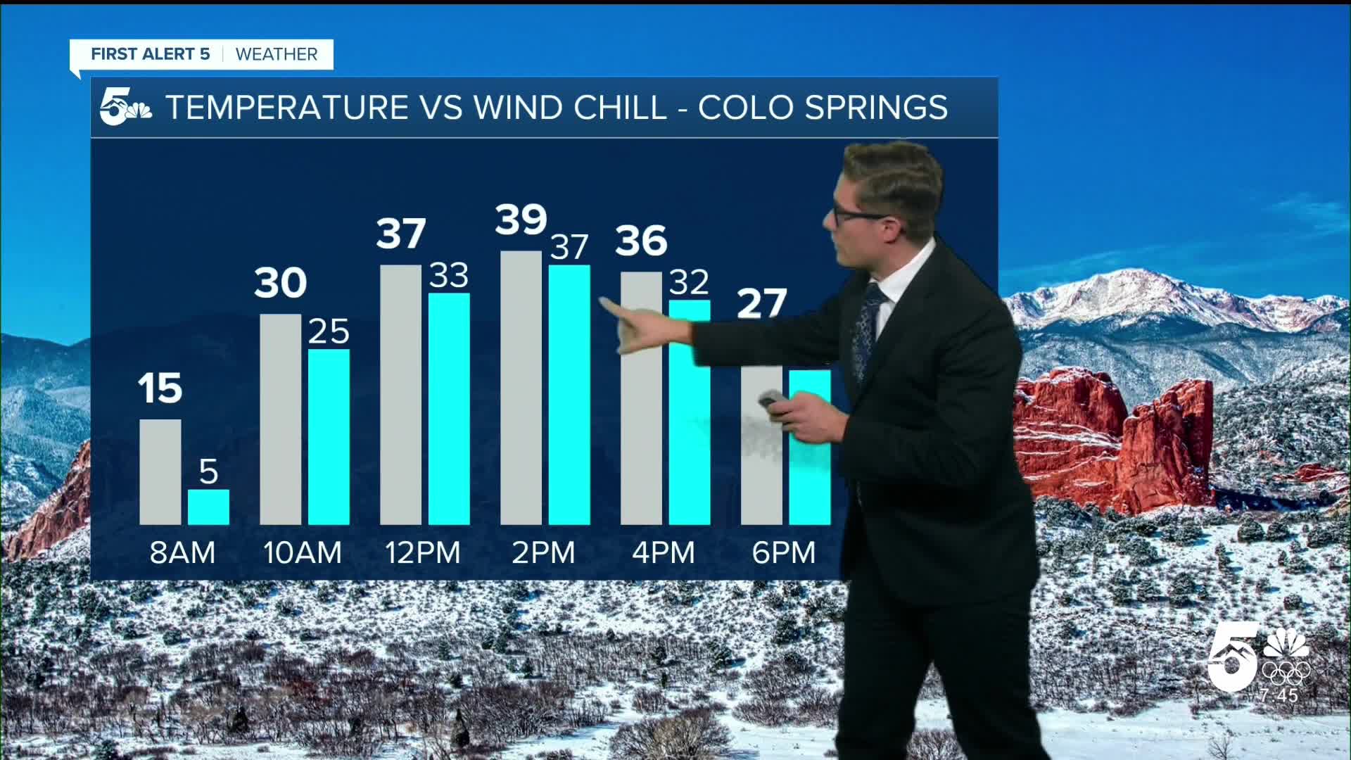
Sunny and cold. Generally light winds, at times up to 10 mph from the north northwest, which will keep wind chills in the middle 30s. An actual winter feeling day! Snow will sublimate pretty efficiently today, so if your kiddos want to go sledding...your best bet is this morning.
Pueblo forecast: High: 40; Low: 15.
Sunny. Your temperature forecast today is a bit trickier than usual due to the snow cover. I'm keeping you warmer than the Springs because on a typical sunny day, the air mixes pretty well in the bottom few thousand feet of the atmosphere and your lower elevation supports a warmer temperature. However, with a stubborn cold air mass in place, valleys like the ARV can hold onto that cold air if winds don't allow it to drain. In sum - the first half of your day is likely to stay colder than Colorado Springs, with a flip in the mid afternoon as the cold air mixes out. Other than that, periodic breezes up to 15 mph from the northwest. Expect wind chills to stay in the 30s and 20s.
Canon City forecast: High: 44; Low: 16.
Sunny and wintery! West winds at 10-15 mph with a few stronger gusts this morning - which should help you stay a bit warmer than other places today. You've already seen most of your snow disappear from the mountains west of town, and you should be fully rid of rooftop snow sometime this afternoon.
Woodland Park forecast: High: 35; Low: 17.
Sunny and feeling like winter. Northwest winds at 5-10 mph. Skies will remain mostly clear tonight. The hard pack snow on U.S. 24 should largely go away by this afternoon, but your side streets and driveways are likely to still hold some snow and ice tonight (compared with lower elevation zones). Similarly, at least some snow will likely stay on the grass this evening and it should fully melt tomorrow.
Tri-Lakes forecast: High: 30s; Low: Teens.
Sunny and generally fairly quiet. Winds at 5-10 mph from the northwest west of I-25. East of I-25 into Black Forest, some 20 mph gusts are possible which will keep wind chills in the 20s and teens...plan accordingly if you're going for a walk along the Santa Fe Trail.
Plains forecast: High: 30s; Low: 10s.
Sunny with snow melting a bit...but likely to remain on grassy surfaces into Sunday. West winds at 5-15 mph.
Walsenburg and Trinidad forecast: High: 40/41; Low: 13/15.
Sunny with northwest winds at 10-15 mph.
Mountains forecast: High: Teens/20s; Low: 0-10s.
Sunny, cold, snow covered. West winds at 10-15 mph. Avalanche danger is moderate (2/5) in the southern mountains. This is primarily near and above treeline.
Extended outlook forecast:
Lows tonight drop to the teens and 20s tonight, a significant warm-up compared to this morning. Colorado Springs' average low tonight is 18 degrees, so this actually represents a return to above average low temperatures. Pueblo's average low is 15.
As a ridge of high pressure continues to build, temperatures will climb Sunday, Monday, and Tuesday. Sunday will warm to the mid 40s, Monday to the low 50s, and Tuesday to the low to mid-50s in the Pikes Peak Region, and upper 40s, mid-50s, and upper 50s in Pueblo. Periodic wave clouds will drift in and out on Sunday and Tuesday - we'll enjoy some more spectacular Colorado sunrises and sunsets as a result.
A few systems will impact southern Colorado late next week. On Wednesday, a backdoor cold front - e.g. a front from the northeast - will move into the area. This cools temperatures and increases cloud cover. I am monitoring this set up for some possible flurries or light snow showers, because the system should increase moisture across the area enough that any wind into the mountains would develop some light precipitation. That said, the set up lacks any other lifting mechanism to the air, such as an area of low pressure, making significant impacts less likely. I've seen meteorologically worse set ups produce snow showers here though.
Moderate downslope breezes are possible Thursday and they'll warm temperatures to the mid 50s, ahead of another backdoor front that approaches at the end of the week.
____
Curious about the First Alert 5 Weather Storm Impact Scale? Check out our cheatsheet explainer.
Watch KOAA News5 on your time, anytime with our free streaming app available for your Roku, FireTV, AppleTV and Android TV. Just search KOAA News5, download and start watching.
