

Today’s Forecast:
After our first taste of wintry weather in more than 3 weeks on Sunday, cold air is lingering this morning across Southern Colorado. Many of us are waking up to temperatures in the single digits and teens, with wind chill temperatures even colder than that.
Warming will be gradual at first, with highs this afternoon topping out in the 40s in most areas. Sunshine will prevail across the state, with light SW breezes to 10 mph across the I-25 corridor.
Colorado Springs forecast: High: 41; Low: 19. After snow and highs in the 30s on Sunday, old man winter will hang on for one more day, with Monday's forecast featuring sunshine and chilly highs in the lower 40s.
Pueblo forecast: High: 43; Low: 12. Cold, Canadian air will linger in Southern Colorado for the next 24 hours, with high today in the lower 40s and lows tonight falling back down to the teens.
Canon City forecast: High: 44; Low: 24. Temperatures will stay below average this afternoon in eastern Fremont County, with sunshine and mid 40s on tap today.
Woodland Park forecast: High: 40; Low: 17. After a long stretch of warm and dry weather this past month, it will be chilly on Monday, with sunshine and a high near 40 degrees.
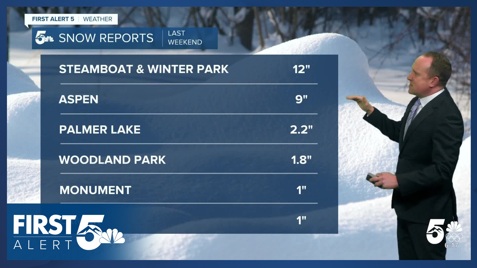
Tri-Lakes forecast: High: 30s/40s; Low: 10s/20s. Light SW wind, sunshine, and colder than average temperatures can be expected this afternoon, with highs warming into the upper 30s and lower 40s.
Plains forecast: High: 40s; Low: 10s/20s. It's been awhile since we've seen cold like we're seeing this morning as many areas are waking up to temperatures in the single digits and teens. Highs this afternoon will be near to slightly below average, topping out in the 40s.
Walsenburg and Trinidad forecast: High: 40s; Low: 10s/20s. Bitterly cold air this morning will give way to sunshine and 40s this afternoon. Don't like the cold? A warm-up will follow starting on Tuesday, with above average highs into the start of 2026.
Mountains forecast: High: 20s/30s; Low: 10s/20s. Skies will be dry for the last Monday of 2025 for the mountain areas. Sunshine and light westerly winds will help to combat those sub-freezing highs that we'll see today in the higher elevations.
Extended outlook forecast:
Tuesday will start out in the 10s and 20s on the Plains, with our highs returning to the 50s by Tuesday afternoon.
High pressure will spread towards the Rockies in the mid-week period. This will set the stage for a warm-up for the Pikes Peak Region and Southern Colorado. Our highs will climb into the lower 60s in Colorado Springs starting on Wednesday, and 60s will continue through the end of the week.
For the AdAmAn club fireworks on New Year's Eve, skies are expected to remain dry, but they will be partly to mostly cloudy as we approach midnight. Temperatures on New Year's Eve will only drop down to the lower to middle 30s in Colorado Springs.
____
Curious about the First Alert 5 Weather Storm Impact Scale? Check out our cheatsheet explainer.
Watch KOAA News5 on your time, anytime with our free streaming app available for your Roku, FireTV, AppleTV and Android TV. Just search KOAA News5, download and start watching.
