


Tonight's Forecast:
Snow is already flying across the Pikes Peak Region, and as the snow level lowers overnight down to near 5,000 feet, we'll see a transition from rain to snow across the Plains and Arkansas River Valley. Areas of highest impact will be for locations above 7,000 feet. This includes the Palmer Divide, Teller County and our local mountains.
Areas of highest impact will be the Palmer Divide, southern I-25 corridor and mountains. Biggest totals (8-12") will be for areas above 7,000 feet. #cowx pic.twitter.com/4amZWcOzck
— Alan Rose (@AlanRoseWX) March 21, 2021
We're also expecting some solid accumulations by Monday morning for northern neighborhoods in Colorado Springs and the southern I-25 corridor.
Winter weather alerts will soon go into effect for parts of Southern Colorado, with a Winter Storm Warning for the Palmer Divide due to heavy snow and gusty winds. #cowx pic.twitter.com/sAgUYAe5g3
— Alan Rose (@AlanRoseWX) March 21, 2021
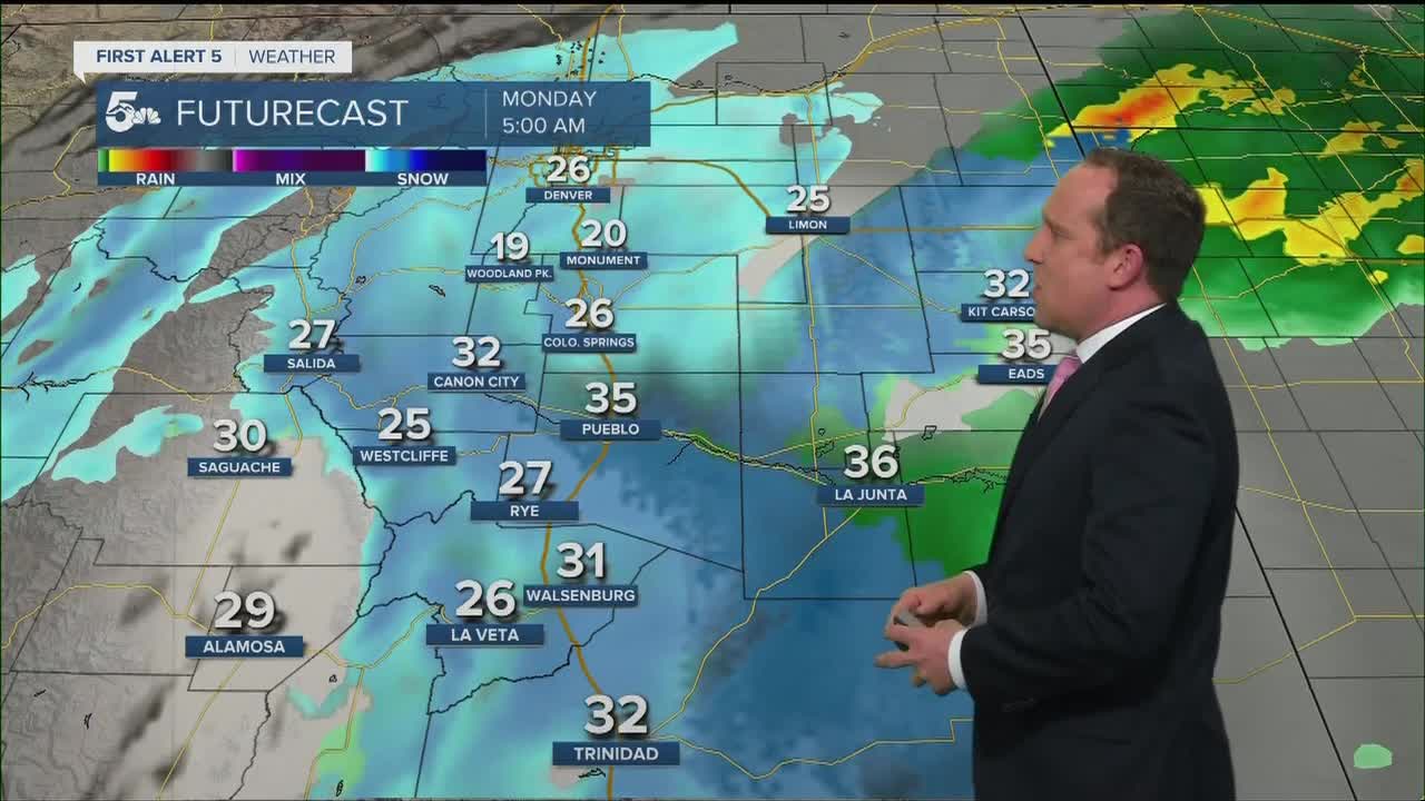
Here's a look at the Snow Forecast through midday Monday:

COLORADO SPRINGS: Low: 26; High: 38. A Winter Weather Advisory will remain in effect until noon Monday, with the heavier snow tapering off to scattered snow flurries by the lunch hour. Accumulations will range from 3-5" on the south side of town to 5-8" for northern neighborhoods.
PUEBLO: Low: 32; High: 42. Rain showers Sunday night will change over to snow as the snow level drops considerably after midnight. Snow amounts in Pueblo County will largely depend on location/elevation and temperature, with a range of 1-4" expected by midday Monday.
CANON CITY: Low: 30; High: 43. A rain to snow mix will take place over Fremont County late Sunday night, with periods of snow through midday Monday. Much like Pueblo, our lower elevation may not allow for much accumulation on streets and sidewalks. Snow totals from 2-5".
WOODLAND PARK: Low: 20; High: 33. Snow will be heavy at times in Teller County through the day on Monday, with some pretty big accumulations expected above 7,000 feet. Snow totals from 9-12" for Woodland Park.
TRI-LAKES: Low: 10s/20s; High: 30s. Palmer Lake to Monument to Woodmoor should be ready for a good amount of snow to fall through midday Monday, and high impacts to travel through Monday evening. Snow totals from 7-10".
PLAINS: Low: 30s; High: 30s/40s. Cooler on Monday, with rain showers likely for the Plains. Some snow will mix in at times, but accumulations will be minimal compared to the rest of Southern Colorado.
WALSENBURG/TRINIDAD: Low: 20s; High: 30s. After a mild weekend, Monday's weather will look and feel much more wintry as snow and colder weather settles in. Snow will taper off by the afternoon, with 5-8" expected in Walsenburg and 3-6" for Trinidad.
MOUNTAINS: Low: 10s/20s; High: 20s. Heavy snow for the mountains, especially the Wet Mountains early this week. More than a foot of snow could fall in the Wets through Monday evening, with 4-8" for the Sangres.
Extended Outlook:
A break from the snow is expected from Monday afternoon through Tuesday morning before another storm pushes in Tuesday afternoon. This storm is likely to take a more southerly track, with the biggest impacts south of Highway 50. For the Pikes Peak Region, it might end up being just some light snow showers that fall. Still more snow is possible into Wednesday from last disturbance. Then our weather will quiet down for one day on Thursday, but will be followed by another potential storm from Friday through Saturday.
KOAA News5 on your time, streaming on your Roku, FireTV, AppleTV and AndroidTV.
News5 App | First Alert 5 Weather App | Youtube | Facebook | Instagram | Twitter
