

Today’s Forecast:
Our well-advertised winter storm is here - as a cold front blasts south this morning through Southern Colorado. High temperatures in most areas have already occurred today. That occurred around midnight in Colorado Springs.
Snow will move in through the morning hours, with a favorable lift and instability in the atmosphere today. In fact, we have three mechanisms to lift the air this morning (which is how we get precipitation). First, the upslope northeast flow driven by the cold front. The second is a bit of atmospheric instability driven by an unusually high amount of moisture in the mid-atmosphere (around the height of Pikes Peak). Finally, we have lift from an area of incoming low pressure system.
With this type of set up, we typically see snow banding, which we're already observing early today. We also see a unique type of storm motion - with showers individually moving to the northeast...even though the low-level airflow and cloud direction appears to move southwest.
Temperatures will drop this morning with today's unofficial high at the Colorado Springs airport of 43 degrees, which was the temperature at around midnight.
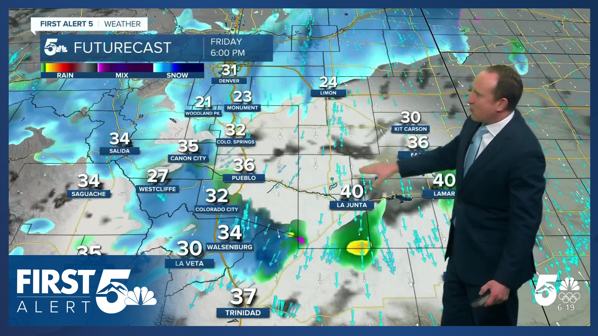
Heading into the morning commute, snow will become steadier and will "fill in". This is when you'll experience more impacts, particularly if you're driving over the Palmer Divide or through the Ute Pass. Snow will be moderate to heavy at times in these quick moving bands within a larger shield of lighter snow.
The heaviest and steadiest snow is likely between 7 AM - 12 PM in the Pikes Peak Region and over Monument Hill and Teller County. As a surface low pivots east, our wind direction will eventually shift from northeasterly to north. This will begin to lighten the snow rate because this is a dry wind direction. You'll continue to see lighter continuous snow through around 2:00 PM as the surface low remains nearby. At the same time, snow will pick up this afternoon across the Wets and Sangres, especially on the eastern slopes.
Snow then becomes patchier and more focused on terrain features through the rest of the afternoon - Woodland Park and the Palmer Divide keep snow showers later than Colorado Springs itself. It comes to an end this evening.
Winter Weather Advisories are in effect for the southeastern mountains, Palmer Divide and Teller County until midnight. Expect some of the snow to be wind driven in these areas, leading to visibility impacts.
Colorado Springs forecast: High: 40; Low: 20. Snow will develop this morning across the Pikes Peak Region, becoming heavier and more widespread throughout the day. Although this storm is colder than Tuesday's storm, elevation will play a big role in snow totals. Areas between 6,000 to 7,000 feet have the most uncertainty, and this includes most of our metro area. Southern parts of Colorado Springs may only see a dusting to a couple of inches of accumulation. Downtown and the airport are looking at 1-3", with 2-6" on the north side of town.
Pueblo forecast: High: 45; Low: 21. After reaching our high earlier in the day around midnight, temperatures will likely hover in the upper 30s and lower 40s during the rest of the day. This is NOT expected to be a big snow maker for Pueblo, with snow levels starting out around 6,000 feet, lowering to around 4,500 this evening. Snow totals under 0.5" in town.
Canon City forecast: High: 40; Low: 22. Today's storm will be multi-faceted for Canon City and eastern Fremont County, with a mix of rain and snow at times, and periods of snow at others. Snow totals of 1-3" are expected.
Woodland Park forecast: High: 30; Low: 11. Cold, windy and snowy weather will return to our forecast on Friday, making this our second winter storm of the week. The worst of the weather is expected to move in by mid to late morning, with periods of moderate to heavy snow through this evening. Snow totals from 4-8", with locally higher amounts.
Tri-Lakes forecast: High: 30s; Low: 10s. The northeast upslope flow and instability from nearby low pressure will team up to bring some heavy snow to the Tri-Lakes today. Heavier, convective snow bands could drop quick accumulations throughout the day today, which will likely result in double digit snow totals in some areas. Even if you don't see a heavier snow band where you live, we're still expecting a good 6-10" region-wide from the storm.
Plains forecast: High: 40s/50s; Low: 10s/20s. Rain and a wintry mix on the Plains, with the rain-snow line not expected to drop much below 5,000 feet this afternoon. Moisture will be highest north of Highway 50, with little rain with this storm over the southeastern Plains. North winds will be gusty today, peaking at around 35 mph.
Walsenburg and Trinidad forecast: High: 40s; Low: 10s/20s. Today's forecast will be cold and unsettled, with rain and snow showers into the southern I-25 corridor. 1-3" of accumulation is likely in the Walsenburg area, with a trace to 2" for Trinidad today. Snow will taper off late tonight.
Mountains forecast: High: 20s; Low: 0s/10s. For the Wet Mountains, Wet Mountain Valley and Sangres, a Winter Weather Advisory will remain in effect until midnight tonight. Today's approaching storm and favorable upslope flow weather pattern will bring a beneficial shot of moisture to the high country. As much as 8-14" of snow is expected. This of course will make for difficult travel in and out of high country today and tonight.
Extended outlook forecast:
We go right back to the same old pattern on Saturday, with high pressure returning and mainly sunny skies. Temperatures will remain somewhat brisk with highs in the upper 40s and 50s on the Plains. Still, Saturday is a nice day that we can call a classic "snowmelt sunshine" set up.
We continue to warm up Sunday with highs rocketing right back into the 60s and low 70s on the Plains. We keep quiet conditions with warming temperatures through Tuesday with a cold front arriving to cool temperatures Wednesday. We'll begin watching for some increasing breezes and low humidity in the second half of next week.
____
Curious about the First Alert 5 Weather Storm Impact Scale? Check out our cheatsheet explainer.
Watch KOAA News5 on your time, anytime with our free streaming app available for your Roku, FireTV, AppleTV and Android TV. Just search KOAA News5, download and start watching.
