

Today’s Forecast:
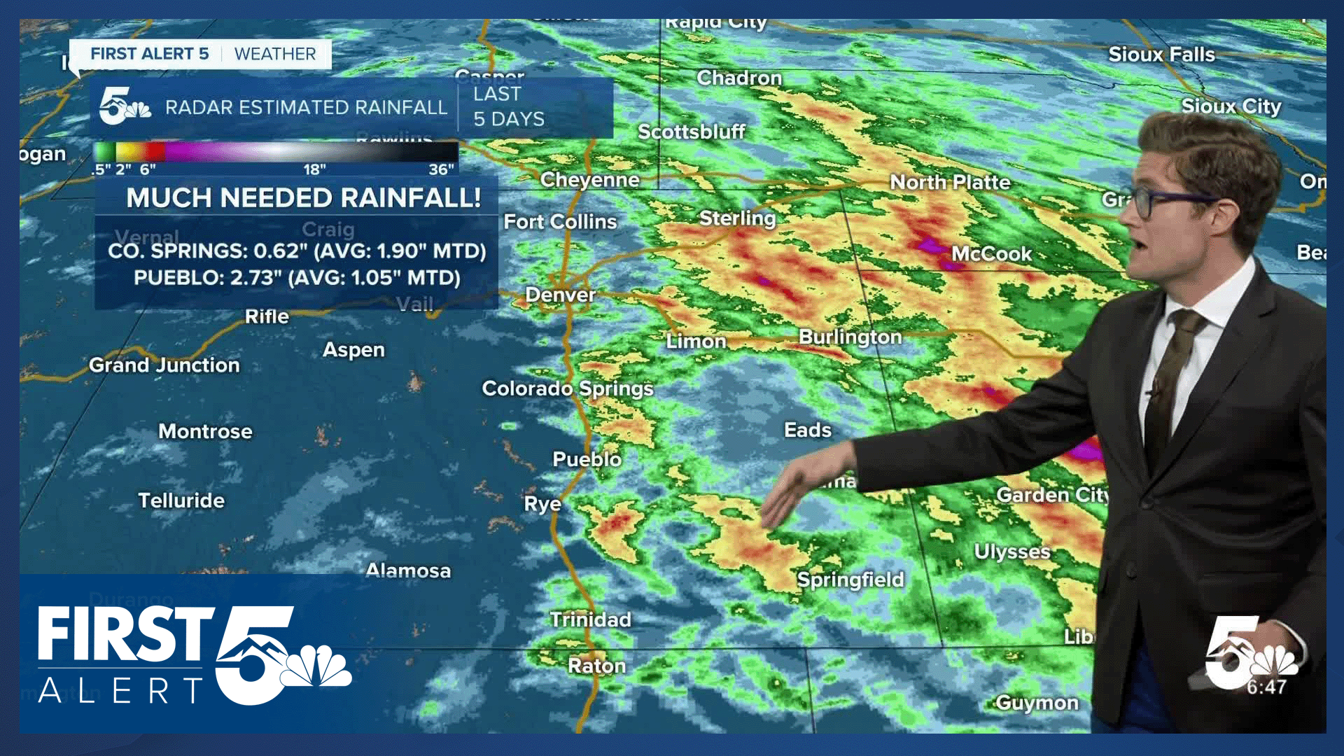
Severe storm threats will be lower today than they've been all week, with only a marginal risk of strong storms across the eastern plains. But we still have plenty of storm juice (moisture) along I-25 with dew points in the 50s this morning, and low 60s on the eastern plains. That's about as wet as we get here in eastern Colorado. This storm juice will allow isolated storms to form in the mountains with a passing disturbance this afternoon, moving into the Colorado Springs area toward 3 PM. Heavy rain and lightning are the main concerns with storms today with small hail along and west of I-25. These storms should move into the eastern plains toward 4-6 PM and will encounter more instability and wind shear. Hail as big as half-dollar sized (1.25") and 60 mph wind gusts will be possible on the plains with the strongest storms.
Date night plans should be dry tonight - no late evening rumblers, and skies will be partly cloudy. Highs today will rebound to the middle 80s with decreasing clouds this morning, becoming mainly sunny by lunchtime. Partly cloudy skies this afternoon.
While the moisture is good news, drought issues persist in the mountains, and fire threats will roar back this weekend. See the extended forecast for details there.
Colorado Springs forecast: High: 83; Low: 54.
Decreasing clouds this morning - mostly sunny by lunch. It'll feel a bit sticky this morning with dew points in the 50s. That feeling should decrease by lunchtime, but there will be enough storm fuel for some afternoon boomers. They form in the mountains by noon, and will move into the Pikes Peak Region toward 3:00 PM. Heavy rain and gusty wind with these scattered storms. They push east by 5 PM with clearing skies this evening. Warm, with south southeast winds at 10-15 mph.
Pueblo forecast: High: 90; Low: 57.
Mostly sunny this morning with scattered afternoon t-storms. Back to the heat today, too. Storms today will not pack the punch of the ones you saw earlier this week, but remain capable of heavy rain, small hail, and gusty wind. We'll take all the moisture we can get, though! Southwest winds swinging southeast this afternoon, generally light at 5-10 mph.
Canon City forecast: High: 90; Low: 60.
Mostly sunny this morning with isolated afternoon thunderstorms. Severe storms are not expected. West winds at 5-10 mph shifting southwest this afternoon.
Woodland Park forecast: High: 78; Low: 51.
Mostly sunny with scattered afternoon thunderstorms. Timing in the 12-2 PM range for you today, so get the hikes in early! South winds at 10-15 mph.
Tri-Lakes forecast: High: 80s; Low: 50s.
Mostly sunny with scattered PM t-storms. South winds at 10-15 mph.
Plains forecast: High: 80s; Low: 50s/60s.
Mostly sunny this morning, with breezy upslope winds this afternoon at 15-25 mph out of the southeast. Dew points in the 50s to near 60 will support a threat for isolated strong storms. Strong wind gusts are the primary threat, followed by large hail to the size of half dollars (1.25") with the strongest storms. I expect a linear storm structure today, which favors wind a bit more than hail, but embedded hail is still possible in the late afternoon to early evening line.
Walsenburg and Trinidad forecast: High: 88/91; Low: 60/59.
Mostly sunny this morning, with isolated PM thunderstorms. West winds at 10-20 mph.
Mountains forecast: High: 70s/80s; Low: 50s.
Mostly sunny this morning, with -early- thunderstorm development -before- noon today! Be off of mountain summits before noon as mid-level energy and typical summer heating spark storms over the high summits. Storms move east this PM. Small hail is possible with mountain storms today.
Extended outlook forecast:
A pattern flip arrives Saturday with moisture moving eastward out of the state, and dry downslope winds returning. A powerful ridge will set up shop over the central US, with low pressure to the west. This classic upper-level pattern funnels enhanced southwesterly winds over the state. Highs Saturday climb to the lower 90s in the Pikes Peak Region to near triple digits down in Pueblo, and it will be gusty. Expect southwesterly winds at 20-25 mph in the afternoon, gusting 35-40 mph. Stronger gusts west of I-25 in the mountains and upper Arkansas River Valley.
We keep the rinse and repeat pattern without the rinse through the weekend and first half of next week, with continued heat and dry gusty conditions. It will be similarly gusty on Sunday, with high fire threats for portions of the area. While weather conditions will favor high fire threats everywhere, the main fire danger will be west of I-25, where less rain has fallen in the past week and fuels remain dry. Avoid outdoor burning such as campfires, and other activities that could produce a wildfire in the mountains this weekend.
It'll be a bit less windy Monday and Tuesday, but still gusty, and it will remain hot with highs in the upper 80s to low 90s.
____
Curious about the First Alert 5 Weather Storm Impact Scale? Check out our cheatsheet explainer.
Watch KOAA News5 on your time, anytime with our free streaming app available for your Roku, FireTV, AppleTV and Android TV. Just search KOAA News5, download and start watching.
