

Today’s Forecast:
Another very warm day is ahead across southern Colorado. A ridge of high pressure is centered southwest of the state, but it will still influence overall conditions - as it has for the last several days. Highs will warm into the upper 60s to low 70s on the plains and upper 50s to low 60s in the mountains, with increasing clouds late this afternoon as mid-level moisture streams in from the west. Winds today will be lighter than in recent days outside of gap flow regions - east of La Veta Pass into Walsenburg being the main area.
The air remains very dry, so where winds are gusty, fire danger stays elevated.
That said, overall winds today will not be as strong as they were for most of the week.
Today will be the 32nd day of meteorological winter --December 1st to the last day of February -- with a high above 60 degrees in Colorado Springs. This beats the old record of 22 days, by 10 days. The average high excluding today is 52 degrees - which is also a record, dating back to 1894. Put another way: more than one out of every three days this winter, has had a spring-like high temperature. The average from 1944-now is 9.21 days.
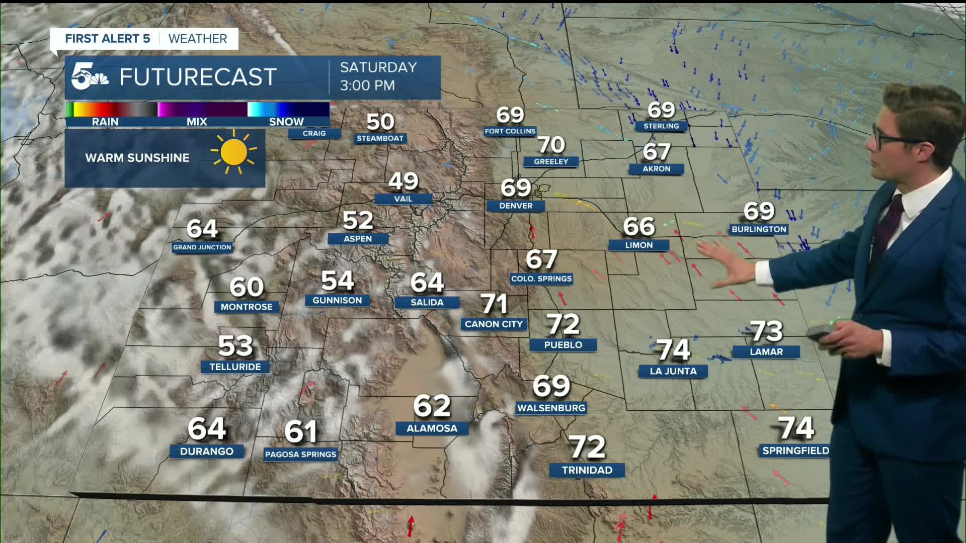
Colorado Springs forecast: High: 67; Low: 36.
Sunshine and a quick warm up this morning with north winds at 5-10 mph. Winds shift southeast in the afternoon, at 5-15 mph. Increasing clouds late in the afternoon becoming mostly cloudy tonight. Overall - beautiful conditions for outdoor activities.
Pueblo forecast: High: 73; Low: 35.
Warmth and downslope westerly winds in the morning at 5-15 mph, gusting to 25 mph before noon west of I-25. West of I-25, use caution with outdoor burning as gusty wind & low humidity will elevate fire danger. Winds shift east southeast this afternoon at 5-15 mph. This will not do much to increase humidity though, which stays low into the evening.
Canon City forecast: High: 72; Low: 42.
Warm and sunny today - as Royal Gorge Park debuts their new clear-floored gondola. Westerly winds this morning, shifting east this afternoon remaining 5-10 mph all day.
Woodland Park forecast: High: 60; Low: 33.
A mostly sunny Saturday in Teller County with westerly breezes at 10-15 mph. Increasing clouds at sunset becoming mostly cloudy tonight.
Tri-Lakes forecast: High: 60s; Low: 30s.
Sunny and mild with southwest winds at 5-10 mph shifting southeast this afternoon.
Plains forecast: High: 70s; Low: 30s.
Sunny and very warm with highs into the mid 70s in some spots. West winds - weak, shifting east at 5-10 mph this afternoon.
Walsenburg and Trinidad forecast: High: 69/72; Low: 39/38.
Sunny with west winds at 10-15 mph, gusting 35-40 mph before noon.
Mountains forecast: High: 50s/60s; Low: 30s.
Sunny and warm with weak westerly winds at 5-10 mph. Becoming cloudy tonight.
Extended outlook forecast:
A weak backdoor cold front will push in tomorrow morning at the same time as an upper-level disturbance tracks generally into the northern half of the state. In Colorado Springs, this will lead to increasing clouds on Sunday and cooler highs in the lower 60s. A quick sprinkle is possible across northern El Paso county, into Teller County.
Downslope wind returns on Monday and highs rebound back to the upper 60s to low 70s on the plains ahead of the first of two incoming areas of low pressure. Sustained winds of 10-15 mph from the southwest are likely, gusting 15-25 mph, along with dry air. This will lead to a return to more elevated fire potential on Monday that we'll need to keep an eye on in gap flow zones.
Northerly tracking low pressure arrives Tuesday and swings a cold front south across the area, which will be gusty. Highs will fall to the low 50s - close to seasonal for this time of year and may be reached relatively early in the day, too. The front will bring in rain showers during the afternoon and evening, with a wintry mix to snow in Teller County.
We return to warmth and sunshine Wednesday and Thursday, ahead of another low pressure system arriving on Friday. This system at the least has a bit more cold air, so it will result in more of a cooldown than you see on Tuesday. For now, there's a chance of a wintry mix on Friday.
____
Curious about the First Alert 5 Weather Storm Impact Scale? Check out our cheatsheet explainer.
Watch KOAA News5 on your time, anytime with our free streaming app available for your Roku, FireTV, AppleTV and Android TV. Just search KOAA News5, download and start watching.
