

Tonight's Forecast:
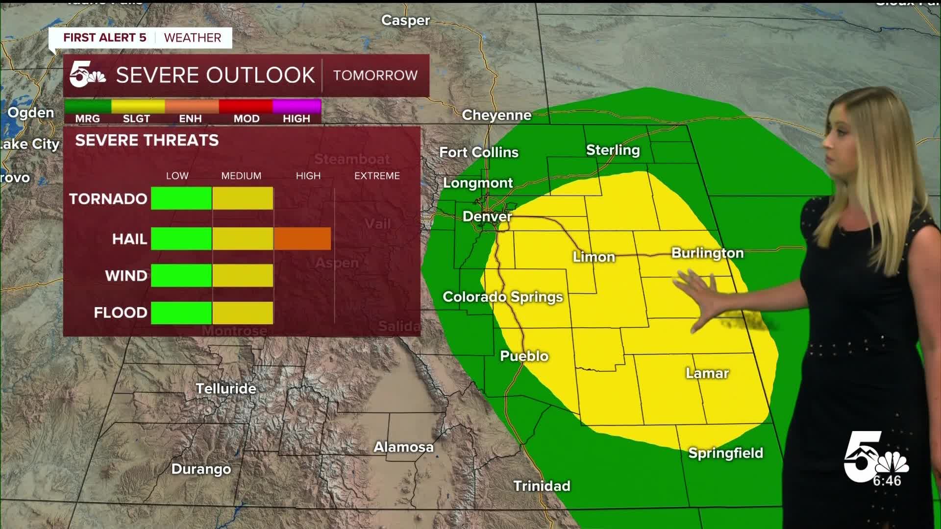
A cold front moves through southern Colorado overnight. The front could initially spark some late-night thunderstorms along I-70 in the plains. Better thunderstorm chances will follow on Saturday afternoon. This will cool down temperatures for Saturday as well, back down to normal levels.
Colorado Springs forecast: Low: 57; High: 86;
Partly cloudy and warm on Saturday. Winds will be variable, at 10 mph with gusty winds in the afternoon as storms develop. Thunderstorms will be possible between about 1-6 pm, some of which may be severe with the risk of large hail, a tornado, severe winds, and heavy rain.
Pueblo forecast: Low: 62; High: 94;
It will be warm and dry for the first part of the day. Thunderstorms will be possible between about 2-7 pm, some of which may be severe with the risk of large hail, a tornado, severe winds, and heavy rain.
Canon City forecast: Low: 62; High: 91;
Saturday will be a bit cooler, but still feeling the summer warmth. It will be partly cloudy with the chance of an isolated thunderstorm in the afternoon.
Woodland Park forecast: Low: 49; High: 79;
Partly cloudy on Saturday with a risk of thunderstorms in the early afternoon.
Tri-Lakes forecast: Low: 54; High: 83;
Partly cloudy and warm on Saturday. Strong to severe thunderstorms will be possible after noon through about 5 pm.
Plains forecast: Low: 50s-60s; High: 80s-90s;
It will be a warm day on Saturday, but thankfully staying out of the triple digits. Strong to severe thunderstorms will be possible from the late afternoon through the evening. The main risk will be for large hail, with a tornado possible as well as strong wind gusts.
Walsenburg and Trinidad forecast: Low: 59/58; High: 91/94;
It will be partly cloudy and still quite warm on Saturday. The storm chance will be low, but an isolated thunderstorm is possible.
Mountains forecast: Low: 40s-50s; High: 70s-80s;
The mountain valleys will still be quite warm and dry on Saturday. Fire danger will still be high, so please heed all burn bans.
Extended outlook forecast:
Sunday will be even cooler, to the 70s and 80s, with another chance of afternoon thunderstorms. Some storms on Sunday could be strong, but the severe weather threat will be a bit lower than Saturday's threat.
We will be drying out and warming back up to the upper 80s to low 90s next week, after another cooler day Monday.
____
Curious about the First Alert 5 Weather Storm Impact Scale? Check out our cheatsheet explainer.
Watch KOAA News5 on your time, anytime with our free streaming app available for your Roku, FireTV, AppleTV and Android TV. Just search KOAA News5, download and start watching.
