

Tonight's Forecast:
It will be a fairly mild Mother's Day evening. Dew points - which measure how wet or dry the air is - are high across the plains. Wet air takes more energy to heat and cool than dry air does, so your temperatures will decline slower than average tonight. You'll want a light layer if you're going on an evening walk with mom. Skies will become increasingly clear overnight.
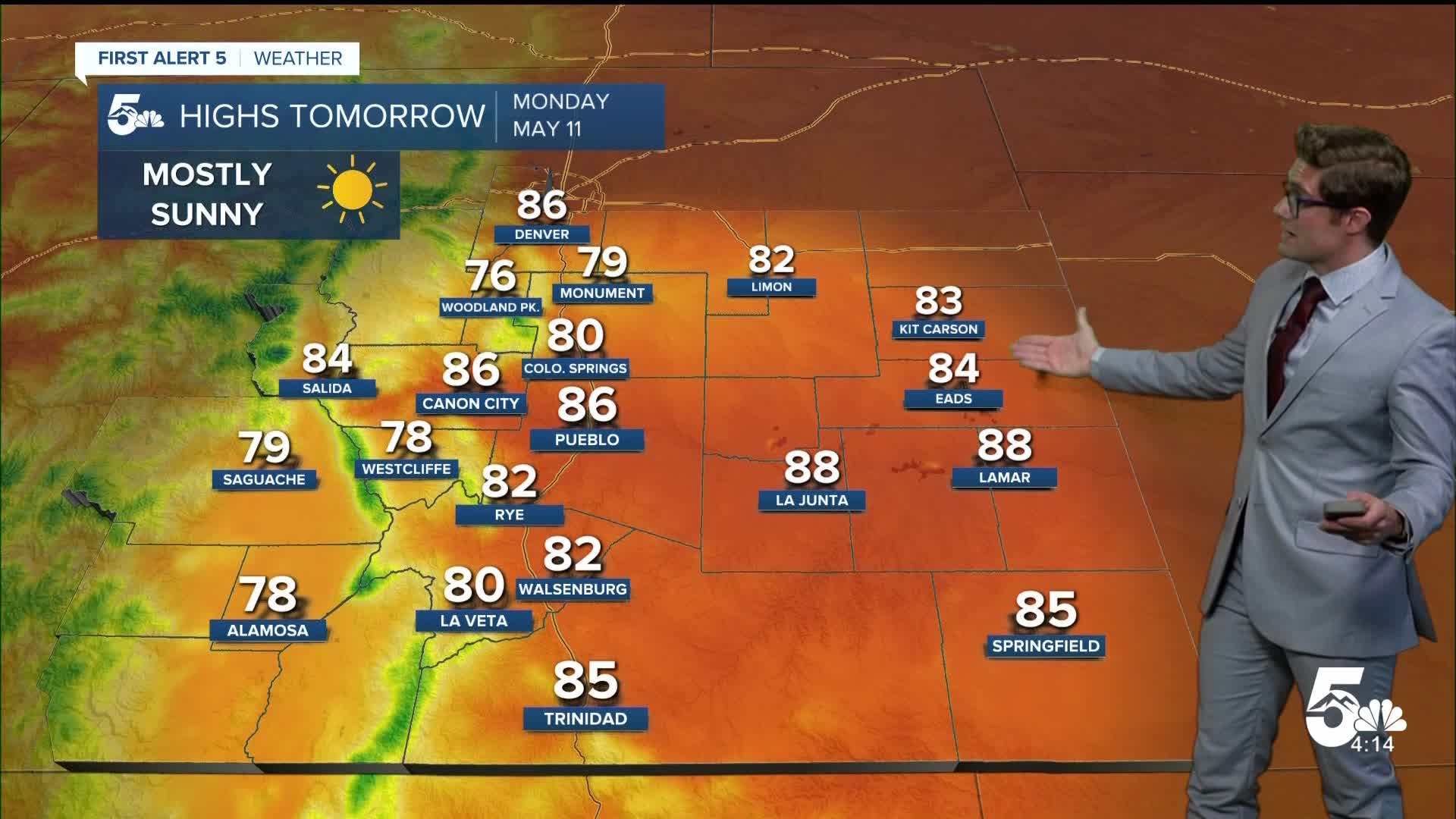
Colorado Springs forecast: Low: 41; High: 80;
Increasingly clear skies tonight, with relatively light winds in the 3-6 mph range. Temperatures fall slower than average before midnight due to the relatively wet air in place. But, after midnight, winds become particularly light which will allow for efficient radiational cooling. Hot on Monday, with quickly dropping dew points and noticeable but non impactful afternoon breezes from the southeast, eventually shifting east.
Pueblo forecast: Low: 43; High: 86;
Clear skies, and fairly calm conditions overall. Southeast winds at 5-10 mph becoming light overnight. Clear and very warm on Monday with southeasterly winds, gusting to 20 mph in the afternoon.
Canon City forecast: Low: 44; High: 86;
Clear and mild this evening with mainly light winds. A slight trend toward a northwest flow for the occasional wind will keep you slightly warmer than Pueblo. On Monday it will be hot, with a south southeast wind. Normally in this setup you're about 1-3 degrees cooler than Pueblo, but in this case you're also at the intersection of northwest winds to your west and that southeast flow. So, despite the upslope wind, you should end up at about the same temperature as areas east.
Woodland Park forecast: Low: 35; High: 76;
Mostly clear and cool. Patchy frost is possible west of town toward Divide. Otherwise, a pleasant and tranquil evening. Mostly sunny and beautiful on Monday.
Tri-Lakes forecast: Low: 40s; High: 70s;
A few passing clouds, early, then clear overnight. Southerly winds - generally less than 10 mph. Sunny and warm on Monday with a light southerly breeze continuing.
Plains forecast: Low: 30s/40s; High: 80s;
Mostly clear and mild with light winds out of the south. Sunny and hot Monday.
Walsenburg and Trinidad forecast: Low: 40; High: 82/85;
Mostly clear with southeast winds at 5-10 mph before midnight and southwest after midnight. Sunny and hot on Monday.
Mountains forecast: Low: 50s; High: 70s;
Motly clear with light and variable wind. Mostly sunny Monday. Expect elevated streamflow rates as snowmelt rates quickly elevate.
Extended outlook forecast:
It will be very warm in southern Colorado on Monday, with highs in the 80s for readers along I-25, and upper 70s in the lower mountain zones. Skies will be sunny, and the wind will be out of the north early in the morning, but mainly out of the south during the day time hours. It may be modestly breezy on the southern aspects of the Palmer Divide, and it will be dry during the afternoon with most of the plains sitting in the teens for relative humidity.
High pressure continues to build across the desert southwest for much of next week. A cold front will arrive on Tuesday morning, which should bring gusty breezes for a few hours for the majority of those reading this article. By the afternoon though, the high-pressure wins - and it gets hot again. The best chance of breaking or tying a temperature record this week in Colorado Springs is on Wednesday.
Isolated thunderstorms are possible in the mountains Thursday and Friday. On Thursday, that chance extends into the Palmer Divide and zones north of highway 50 on the plains. It will also turn breezier late this week for most areas as the ridge begins to shift east. This will lead to at least patchy high fire danger.
____
Curious about the First Alert 5 Weather Storm Impact Scale? Check out our cheatsheet explainer.
Watch KOAA News5 on your time, anytime with our free streaming app available for your Roku, FireTV, AppleTV and Android TV. Just search KOAA News5, download and start watching.
