

Today’s Forecast:
We're heating up today in southern Colorado, 70s in the high country, 80s along the Front Range, and 90s on the plains...seasonal for this time of year.
Avoid long intense outdoor workouts this morning, particularly if you have respiratory conditions like Asthma or COPD, or you are sensitive to air pollution. Air quality this morning is moderate due to wildfire smoke from intense fires in Utah, and Arizona at the Grand Canyon across southern Colorado.
Keep in mind that smoke is thicker at the height of some of our taller mountains...between around 10,000 and 14,000 feet. We do not have air quality sensors in these areas - so just be prepared for more haze and smoke density if you're in the high mountains this weekend for any reason.
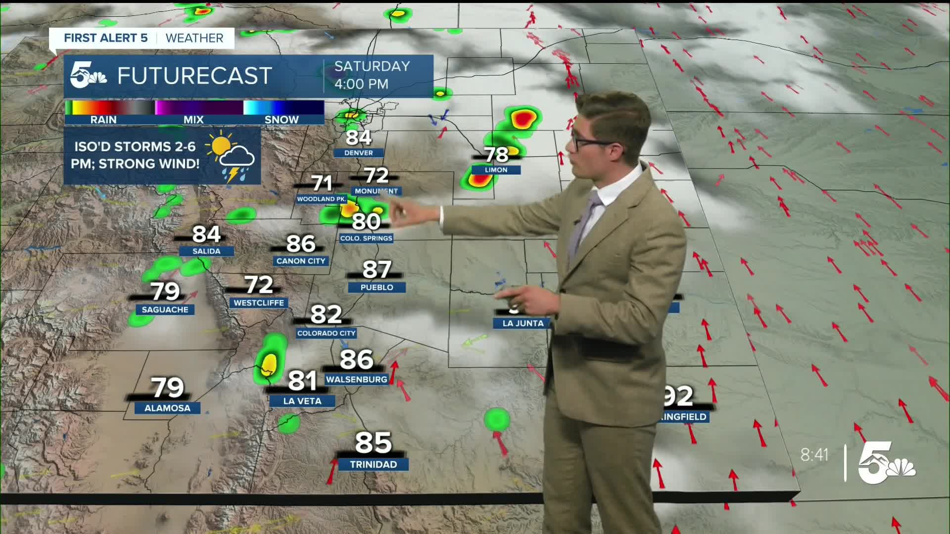
Isolated storms are possible again this afternoon. Storm coverage will be lower than it has been in the last few days and storms will move more quickly too. As usual, storms begin in the early afternoon in the mountains, with the Front Range potential maximized between 2-6 PM, and 3-9 PM on the plains. Due to drier low level air today, storms that do form over the Front Range have a high potential to produce strong wind gusts (we call them outflow winds).
Moisture is much higher over the eastern plains, which the Storm Prediction Center has highlighted in a slight 2-out-of-5 risk for severe weather today. In our eastern counties, large hail to to the size of a hen egg (2") is possible, along with strong wind.
For most of the Front Range and mountains- outdoor patio dining plans or an evening walk with the dog will be quite pleasant as storms will have pushed into the eastern tier by then. A brief passing shower is possible late with the best chance of that over the Palmer Divide with otherwise partly cloudy skies tonight.
Colorado Springs forecast: High: 87; Low: 54.
Mostly sunny through 1:00 PM. Scattered thunderstorms between 2-6PM. Storms will be less widespread today and move faster but the potential for gusty wind and hail does remain. The headline is - it's a nice day, but don't expect it to be dry everywhere all afternoon, and plan your outdoor activities (and places to go inside), accordingly. Southwest winds at 5-10 mph shifting west in the afternoon.
Pueblo forecast: High: 93; Low: 57.
Mostly sunny through 2:00 PM. Isolated thunderstorms possible between 2-6 PM. Storms will be less widespread today, but the potential for strong wind gusts increases with storms that do form.
Canon City forecast: High: 91; Low: 59.
Sunny through noon - then increasing clouds (which as usual will move in from your west). Scattered thunderstorms between 1-6 PM today. Expect a mainly nice day, with a storm thrown into the mix. Since lightning is still a concern, avoid having no "indoor options" during the middle afternoon. West winds at 10-15 mph.
Woodland Park forecast: High: 79; Low: 46.
Sunny through 11 AM, then increasing clouds. A thunderstorm is likely this afternoon; several storms are not. Plan accordingly. West winds at 10-15 mph.
Tri-Lakes forecast: High: 80s; Low: 50s.
Mostly sunny through 1:00 PM, with scattered afternoon thunderstorms possible. West winds at 5-10 mph.
Plains forecast: High: 90s; Low: 50s.
Sunny through around 3:00 PM. Strong thunderstorms are possible this afternoon and evening. South winds at 10-20 mph.
Walsenburg and Trinidad forecast: High: 88/90; Low: 54/53.
Mostly sunny through 12:00 PM. Scattered storms are possible in the afternoon. West winds at 10-15 mph.
Mountains forecast: High: 70s; Low: 50s.
Sunny through 11 AM, then partly cloudy with scattered afternoon thunderstorms. Smoke from wildfires will impact your air quality. West wind at 10-15 mph.
Extended outlook forecast:
High pressure and a plume of dry air will combine Sunday to provide a drier forecast. A weak cool boundary will push south in the early afternoon. Overall it's a nice outdoor day, with continued isolated storm chances favoring the eastern counties well east of I-25.
We continue to heat up and dry out for most of the upcoming work week. A plume of very dry air from the Baja California region and equatorial pacific continues to move into the state, which limits storm development. Meanwhile, the incoming high will push down on the air above - which will also stop storm development and lead to warming temperatures. The entire week will be a sizzler - with record breaking potential maximized on Tuesday. Mountain moisture begins to return Wednesday afternoon but is more notable on Thursday and Friday with both days likely to see a return to PM mountain t-storm chances.
____
Curious about the First Alert 5 Weather Storm Impact Scale? Check out our cheatsheet explainer.
Watch KOAA News5 on your time, anytime with our free streaming app available for your Roku, FireTV, AppleTV and Android TV. Just search KOAA News5, download and start watching.
