



COLORADO SPRINGS, Colo. (KOAA) — Today’s Forecast:
Isolated thunderstorms remain possible today in southern Colorado, although overall storm coverage is going to be down from recent days. The last in a parade of weak upper-level disturbances will cross Colorado today, providing the lift for storms this afternoon. Low-level moisture looks slightly lower today right along I-25, and a building high over the state will also reduce storm action in the mountains. Gusty winds remain possible with any storm.
The first half of your day will be mainly sunny and dry - no morning showers like you saw on Thursday. Expect comfortably warm temperatures by noon in the low 80s in the Pikes Peak Region, and upper 80s in Pueblo. Clouds increase during the mid-afternoon west to east, with isolated thunderstorms between 12-6 PM along I-25. Storms on the plains from 2 PM - Midnight.
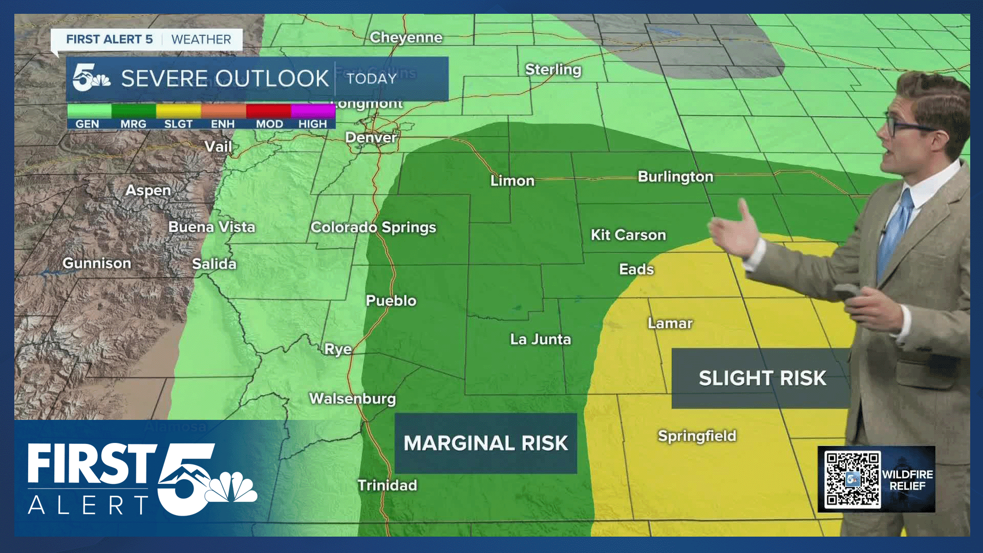
Storms will gain strength as they march east across the plains, as they have in the last two days. Severe storms are possible over the far southeastern plains with 1.5" hail, and wind gusts to 65 mph the main hazards from the strongest storms.
Colorado Springs forecast: High: 86; Low: 57.
Sunny this morning with light haze - air quality should be OK. Comfortably warm at lunch, with a developing easterly upslope breeze. Afternoon thunderstorms are again possible today, and look similar to the last two days: patchy, capable of producing gusty wind, small hail, heavy rain, and frequent lightning. Storm coverage today should be more isolated though with about a 3-in-10 chance of seeing one at your home. Timing is between 12-7 PM.
Pueblo forecast: High: 92; Low: 61.
Sunny with light haze this morning and isolated heavy thunderstorms this afternoon, like you've seen the last two days. But, fewer storms today than yesterday. Easterly upslope winds at 10-15 mph. Enjoy the relatively seasonal warmth today, because it's going to be hot starting tomorrow...for the foreseeable future.
Canon City forecast: High: 92; Low: 61.
Sunny this morning with isolated PM thunderstorms. East winds at 5-10 mph this afternoon.
Woodland Park forecast: High: 81; Low: 50.
Sunshine on your finally Friday this morning with our classic summer pattern in place again this afternoon. Expect scattered afternoon thunderstorms between 12-7 PM. You do once again have the chance to see more than one storm today...but we're not looking at particularly notable rain with them. Be prepared as usual to head inside in the afternoon if you see the darkening cloud bases approaching (and if you hear thunder).
Tri-Lakes forecast: High: 80s; Low: 50s.
Mostly sunny this morning with isolated afternoon thunderstorms. East winds this afternoon at 5-10 mph.
Plains forecast: High: 90s; Low: 60s.
Sunny this morning with partly cloudy skies this afternoon. Isolated but strong thunderstorms from mid afternoon to the evening across the southeast tier. Hail to ping pong ball size (1.5") and 65 mph wind gusts will be the main issues with the strongest cells.
Walsenburg and Trinidad forecast: High: 89/93; Low: 59/58.
Sunny this morning with scattered PM thunderstorms. West winds at 5-10 mph this morning, shifting east this afternoon.
Mountains forecast: High: 80s; Low: 50s.
FLASH FLOOD WATCH from 12:00 PM - 8:00 PM for the Aspen Acres burn scar
Mostly sunny this morning with smoke and haze. Isolated PM thunderstorms capable of heavy rainfall. East winds at 5-15 mph this afternoon, except near thunderstorm outflows where strong and erratic winds are possible.
Extended outlook forecast:
An isolated storm or two remains possible, tied to the mountains, on Saturday afternoon, but it won't be the main story, even if you do get some rain.
High pressure begins to nose north this weekend, and we'll heat up. Colorado Springs' airport recorded 10 90 degree or warmer days in June, and 3 so far this July. We will be in the 90s starting Saturday, for the foreseeable future. The longest ever stretch of 90+ high temperatures in Colorado Springs, ran from late June to early July 2012 when we hit at least 90 degrees for 14 consecutive days. That's not likely here, but it does look likely for us to see a week or more of 90+ highs.
This heat will be accompanied by upslope winds, that will be gusty at times. The combination of heat and wind is not good news for fire threats - which are likely to increase late this weekend into next week as fuels dry out.
____
Curious about the First Alert 5 Weather Storm Impact Scale? Check out our cheatsheet explainer.
Watch KOAA News5 on your time, anytime with our free streaming app available for your Roku, FireTV, AppleTV and Android TV. Just search KOAA News5, download and start watching.
