

Today’s Forecast:
Severe thunderstorms are possible today in southern Colorado, and at least a couple of these storms are likely to be significant - with very large hail (2-2.5" possible...Lime to Tennis Ball sized), strong wind, and an isolated threat of flash flooding. There is the potential for an isolated spin up tornado as well. Although storms will be severe, they'll also be isolated. So you may see no storm at all today - but if you get a storm, it's quite likely to be significant.
Several ingredients are coming together to provide storm risks across southern and eastern Colorado. First is increased moisture due to a cold front that passed through last night. Second, an upper-level wave is on the way in from the west. As this wave arrives this afternoon, it will increase wind speeds in the mid and upper levels of the sky - about the height of our 14-thousand-foot peaks. At the same time, we will have surface upslope winds, out of the southeast. When we have wind going one direction at the ground, and the opposite direction high in the atmosphere, thunderstorms can become highly organized.
The hail threat is coming from the middle atmosphere, which will be quite cold. This cold layer will help with hail formation. Combined, storms today will trend toward what we call supercells. These are large and tall rotating thunderstorms and tend to produce most significant severe weather. So, if you get one, expect it to pack a punch and be prepared to move your car (and yourself) under shelter if at all possible. Isolated instances of tennis ball sized hail (or larger) are possible with the strongest storms.
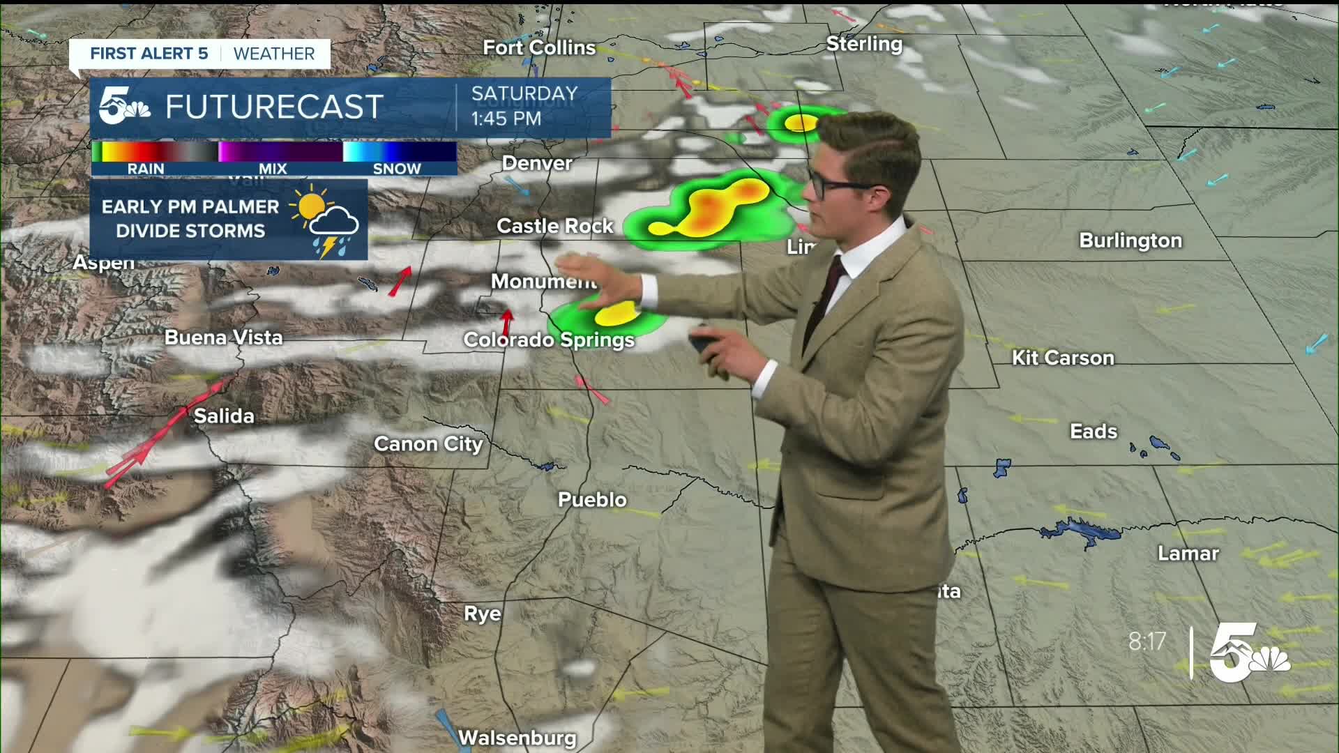
Storms should first spark off in the early afternoon over the Palmer Divide. They'll move south and east through the afternoon hours eventually moving to the southeastern plains by sunset. Due to the upper-level energy, we have some additional storm potential late in the day after sunset into the overnight hours. This potential is low, but spread out, as it will partly depend on outflow boundaries pushing out from the storm complexes earlier in the day. Therefore, you should have a way to receive weather alerts throughout the day, and ideally more than one. I really want to emphasize the isolated nature of storms today - some of us are going to get a significant storm and others won't.
Colorado Springs forecast: High: 87; Low: 55.
Sunny with light haze early becoming partly cloudy by 11 AM. Storms begin in the northern part of the area around 12 PM with the chance of storms increasing throughout the afternoon hours. Storms will be isolated, but strong. This is a good day to keep your radar app handy, and have a way to receive alerts (such as with the News5 app). The severe threat decreases after sunset. Southeast winds at 10-15 mph.
Pueblo forecast: High: 94; Low: 60.
Sunny with light morning haze. Skies turn partly cloudy after 2 PM. Thunderstorms are possible in the late afternoon and evening hours, generally after 4 PM. Storms will be isolated. Southeast winds at 10-15 mph.
Canon City forecast: High: 92; Low: 61.
Mostly sunny through the morning with isolated afternoon thunderstorms, generally after 4 PM. The biggest severe threats are to your east today. South winds at 5-10 mph.
Woodland Park forecast: High: 79; Low: 47.
Sunny through 10AM, then becoming partly cloudy. Scattered thunderstorms are possible after noon. Southwest winds at 10-15 mph.
Tri-Lakes forecast: High: 80s; Low: 50s.
Severe thunderstorms are likely. Mostly sunny early, with storms forming around noon and the potential for severe weather increasing through mid-afternoon. Have a way to receive warnings, and have a radar app handy. Storms will be capable of large hail and strong wind. Follow afternoon updates. South winds at 10-15 mph.
Plains forecast: High: 80s/90s; Low: 50s/60s.
Severe thunderstorms are expected, but will be isolated. Mostly sunny through mid-afternoon, with the main severe weather risk increasing from late afternoon into the evening hours. Storms will be capable of large, damaging hail, strong winds, and an isolated tornado is possible. Remain weather aware and have a reliable way to receive weather warnings. East northeast winds at 5-10 mph.
Walsenburg and Trinidad forecast: High: 92/92; Low: 56/55.
Mostly sunny with isolated thunderstorms possible late in the day. West winds at 5-10 mph.
Mountains forecast: High: 80s; Low: 50s.
Mostly sunny this morning, with isolated afternoon thunderstorms - favoring the mountains immediately adjacent to the plains and I-25. Southeast winds at 5-10 mph.
Extended outlook forecast:
Sunday will start off with a bit of fog across parts of the Arkansas River Valley and Pikes Peak Regions. That reflects continued upslope flow and available moisture and some evaporation from Saturday's storms. That'll burn off relatively quickly with some lingering low clouds through the mid-morning. Thunderstorms are again in the forecast, with at least isolated severe weather again possible. However the overall severe risk will be a bit lower. Storms will also favor the mountains more - and some spots in the mountains could get more than one thunderstorm Sunday, leading to an isolated flood threat. I do think flooding is a bigger concern on the plains Sunday as well - as the ground will already be wet.
Storm timing will be rather typical, in the early afternoon in the mountains, 2-7 PM across I-25, and 4-10 PM across the eastern plains. Due to another batch of incoming upper level energy, storms will once again stick around after sunset, though they're likely to lose at least a bit of strength after sunset. Highs will cool further - with most areas in the 70s to low 80s.
Isolated storms continue Monday, particularly in the mountains, the Palmer Divide, and areas north of highway 50, before we dry out for the rest of the week with isolated daily mountain storms.
____
Curious about the First Alert 5 Weather Storm Impact Scale? Check out our cheatsheet explainer.
Watch KOAA News5 on your time, anytime with our free streaming app available for your Roku, FireTV, AppleTV and Android TV. Just search KOAA News5, download and start watching.
