


Today’s Forecast:
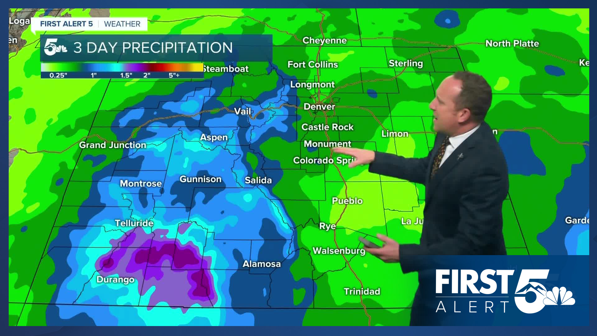
Increasing moisture across the state has brought us mild temperatures this morning, with some areas waking up to the 70s! Partly to mostly cloudy skies have been noted here in Southern Colorado, with showers already moving into the mountains. By the afternoon, heavy rain will pick up in the mountains, especially to the west of the Continental Divide. Scattered showers will reach the I-25 corridor by early this afternoon, with chances for rain region-wide through this evening.
Colorado Springs forecast: High: 84; Low: 57. A quick passing shower will be possible this morning, with chances for rain increasing this afternoon and evening, especially for areas closest to the mountains.
Pueblo forecast: High: 91; Low: 59. In spite of a cloudy start to our Thursday, temperatures this afternoon will still warm into the lower 90s. Increasing moisture late this week will produce widespread storms in the mountains on Thursday, with a slight chance for rain in Pueblo.
Canon City forecast: High: 88; Low: 60. Skies will remain partly to mostly cloudy on Thursday, and with increasing moisture over western Colorado, storm chances will build here locally in the late week period.
Woodland Park forecast: High: 76; Low: 47. Summer-like warmth will continue on Thursday, along with a better chance for summer-time showers and storms. Main storm threats today will include strong wind gusts, hail up to 1" in diameter, and heavy downpours.
Tri-Lakes forecast: High: 70s/80s; Low: 50s. Warm, above average highs and a surplus of moisture this afternoon will bring a better chance for rain today to northern El Paso County. Storms will be capable of brief, heavy downpours, small hail and gusty winds.
Plains forecast: High: 90s; Low: 50s/60s. Mild temperatures this morning will give way to another HOT one on the Plains, with highs this afternoon expected soar into the upper 90s in some areas. Showers and storms on the southeastern Plains will be hit or miss today.
Walsenburg and Trinidad forecast: High: 80s; Low: 50s/60s. While the potential for heavy rain will impact the mountains on Thursday, only a few isolated showers are expected around the southern I-25 corridor.
Mountains forecast: High: 60s; Low: 40s. The higher terrain will be ground zero for today's threats of heavy rainfall and strong to severe storms. While the worst of the weather is expected in the San Juans, the southeastern mountains could see some stronger storms as well today.
Extended outlook forecast:
As an area of low-pressure lifts into the northern Rockies on Friday, we will see a better chance for rain from the mountains to the Plains. Once again, heavy rain will favor the mountain, especially the San Juans and southwestern Colorado. Highs on Friday will be a little cooler, warming into the 60s, 70s and 80s.
This weekend will bring a mixed bag of weather to Colorado Springs and Southern Colorado, with a chance for storms on Saturday and dry skies on Sunday. Highs this weekend will warm into the middle 70s in Colorado Springs before rebounding to the 80s early next week.
____
Curious about the First Alert 5 Weather Storm Impact Scale? Check out our cheatsheet explainer.
Watch KOAA News5 on your time, anytime with our free streaming app available for your Roku, FireTV, AppleTV and Android TV. Just search KOAA News5, download and start watching.
