


Tonight's Forecast:
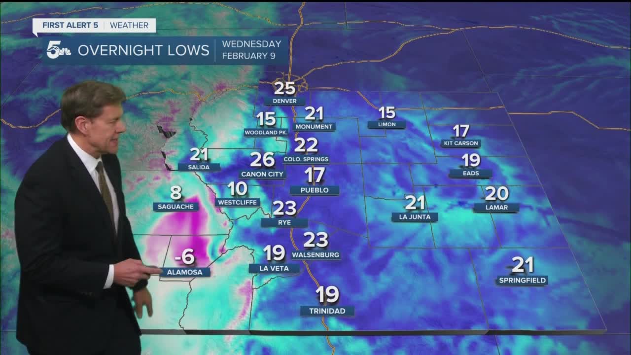
Even after a mild Tuesday, good radiational cooling tonight should allow for at or below seasonal lows across Southern Colorado. It will coldest across the normal valley locations, with places like Saguache and Alamosa dropping down to the single digits and the negatives.
Colorado Springs forecast: Low: 22; High: 50. Another mild day as our afternoon high should climb up near the 50 degree mark. A few light snow showers may develop up near the Palmer Divide, with a few flurries possible in town by early Thursday morning.
Pueblo forecast: Low: 17; High: 54. Lighter breezes on Wednesday, with a few more clouds expected to push into the region by the evening hours, but no real threat of snow.
Canon City forecast: Low: 26; High: 53. Mostly sunny to partly cloudy on Wednesday, and another mild day across the central Arkansas River Valley.
Woodland Park forecast: Low: 15; High: 43; Another weak disturbance is expected on Wednesday, but don't expect anything too exciting as dry skies should persist throughout the day.
Tri-Lakes forecast: Low: 10s/20s; High: 40s. A relatively sunny start to our Wednesday will turn mostly cloudy by the evening. A cold front will bring the clouds, along with a weak shot at light snow or flurries into very early Thursday morning.
Plains forecast: Low: 10s/20s; High: 50s. More mild weather will continue for the Plains on Wednesday, with highs expected to return to the lower to middle 50s.
Walsenburg and Trinidad forecast: Low: 10s/20s; High: 40s/50s. Dry skies and above average highs will continue in our forecast on Wednesday, with no sight of any snowfall through at least the end of the week.
Mountains forecast: Low: 10s/20s; High: 30s/40s. A weak storm system may bring a few very light snow showers to the mountains north of Highway 50 on Wednesday, with totals expected to stay mostly under an inch.
Extended outlook forecast:
Highs will warm up a few degrees Thursday before our next storm drops into Southern Colorado. This one looks to be a little wetter, with at least a widespread chance of light snow showers Friday night into Saturday morning. Totals along the I-25 corridor should stay under an inch. Highs for the Plains will rebound quickly into the 50s and 60s from Sunday into Monday before our next chance for snow around the middle of next week.
____
Watch KOAA News5 on your time, anytime with our free streaming app available for your Roku, FireTV, AppleTV and Android TV. Just search KOAA News5, download and start watching.
