

Today’s Forecast:
High pressure building over the Rockies today will bring a warm-up to Southern Colorado. Highs today will soar into the 70s and 80s on the Plains, and 60s for Teller County and the mountain valleys. That's around 15 degrees above average.
Winds will be mostly on the light side today, blowing from the S/SW at around 10-15 mph. Stronger gusts to 35 mph will be possible today on the far southeastern Plains. Combined with relative humidity in the single digits and teens, a Red Flag Warning has been issued for Prowers and Baca counties, in effect from 11 am to 7 pm. Please avoid outdoor burning on any and all Red Flag Warning days.
Colorado Springs forecast: High: 77; Low: 45. After hitting 70 degrees back on Sunday, our high today will soar into the upper 70s, which is well above the average high of 62. The wind will be out of the southwest and light today, sustained at around 10-15 mph.
Pueblo forecast: High: 83; Low: 41. Temperatures today will be significantly warmer than average, which for this time of the year is still in the upper 60s. Tomorrow will be even warmer, topping out near 86 degrees.
Canon City forecast: High: 80; Low: 45. Warm and spring-like on Monday, with mostly sunny to partly cloudy skies and well above average highs. Today's temperatures will top out in the upper 70s to lower 80s.
Woodland Park forecast: High: 67; Low: 36. After snow on Friday and a warm-up this past weekend, our forecast will continue to trend in this direction early this week, with highs in the upper 60s this afternoon.
Tri-Lakes forecast: High: 70s; Low: 40s. Like Woodland Park, we also saw snow accumulations last Friday. Today will look and feel very different as highs today climb into the lower 70s this afternoon.
Plains forecast: High: 80s; Low: 40s. It will be a warm and breezy start to the week on the eastern Plains, Driven by S/SW wind gusts to 35 mph, highs today will soar into the 70s and 80s. In Prowers and Baca counties, a Red Flag Warning will remain in effect from 11 am to 7 pm.
Walsenburg and Trinidad forecast: High: 70s; Low: 40s. Warm, with lighter wind today, especially compared to what we'll see later this week. Skies will be dry region-wide today, with highs mostly warming into the 70s.
Mountains forecast: High: 50s/60s; Low: 30s. In the mountains, our weather this week will begin on the mild and dry side before turning windy in the mid-week period. Skies today will feature a mix of sun and clouds, with similar to slightly warmer conditions on Tuesday.
Extended outlook forecast:
Tuesday will be our warmest day of the week, topping out at 80 degrees in Colorado Springs. Tomorrow's average high is 62 degrees, and the record is 83, last set in 1989. The wind will be breezy in the afternoon, with gusts to 25 mph. Highs on the eastern Plains will warm into the middle to upper 80s. This includes the Pueblo area.
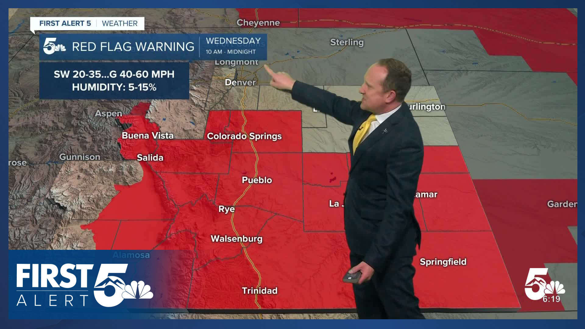
An incoming storm will track over the northern Rockies on Wednesday, sending some significant wind energy into Colorado during the day. Red Flag Warnings have already been issues here, in effect Wednesday from 10 am to midnight. That's a long duration event, and it's possible that some areas in the Pikes Peak Region could gust in excess of 50 mph. Highs will remain very warm Wednesday, topping out in the upper 70s. Gusts south of Highway 50 could top 60 mph .
A cold front drops into Southern Colorado on Thursday, dropping highs down to the 60s in Colorado Springs. Depending on the timing of Thursday's front, we could still see high fire danger in some areas early in the day, especially south of Highway 50. Cooler and unsettled weather conditions will be possible daily from Friday into the weekend.
____
Curious about the First Alert 5 Weather Storm Impact Scale? Check out our cheatsheet explainer.
Watch KOAA News5 on your time, anytime with our free streaming app available for your Roku, FireTV, AppleTV and Android TV. Just search KOAA News5, download and start watching.
