

Tonight's Forecast:
It will be mainly clear this evening in southern Colorado and the winds will remain fairly light - outside of the mountains. Lows will be fairly similar to what you saw this moring - upper 20s to low 30s. If you have lightweight outdoor objects that are not secure, you should secure them or bring them inside this evening if you don't want them to blow away. Also, be wary of parking your vehicle underneath tree branches if possible - this is more a suggestion for tomorrow's forecast. Wednesday brings a blend of High Wind Warnings, and Red Flag Warnings, to the area - with significant, to major impacts. See the extended forecast for more.
Colorado Springs forecast: Low: 29; High: 65;
RED FLAG WARNING in effect from 11:00 AM - 6:00 PM
HIGH WIND WARNING in effect from 2:00 PM - 3:00 AM Thursday
Mostly clear tonight. Winds turn southwest and should remain light into the early morning. Wind will increase early if you live right next to the mountains - Rockrimmon, Broadmoor, Air Force Academy and similar. Otherwise, you'll need to wait until late morning to see the winds really crank up. It will be cloudy during mid-morning, but those clouds should clear in the afternoon. Southwest winds at 15-25 mph, gusting to 40 mph early, then to 60 mph after 2 PM.
Pueblo forecast: Low: 27; High: 70;
RED FLAG WARNING in effect from 11:00 AM - 6:00 PM
HIGH WIND WARNING in effect from 2:00 PM - 3:00 AM Thursday
Mostly clear tonight- secure loose objects or decorations if you can (you also have Wednesday early morning to do this too). Southwest winds will increase Wednesday, strongest in the afternoon and evening when gusts to 65 mph are possible.
Canon City forecast: Low: 33; High: 66;
RED FLAG WARNING in effect from 11:00 AM - 6:00 PM
HIGH WIND WARNING in effect from 2:00 PM - 3:00 AM Thursday
Mostly clear tonight with west winds at 5-10 mph. Winds will increase by late morning Wednesday at 15-25 mph, gusting before noon in the 30-40 mph range and notching up to the 50-55 mph range after 2 PM. It will be mostly sunny.
Woodland Park forecast: Low: 30; High: 56;
HIGH WIND WARNING in effect from 2:00 PM - 3:00 AM Thursday
Mostly clear tonight, and mostly sunny tomorrow. Winds will increase earlier for you than along I-25 (which is typical). West winds at 20-35 mph, gusting to 60-70 mph during the late afternoon and evening.
Tri-Lakes forecast: Low: 30s; High: 60s;
RED FLAG WARNING in effect from 11:00 AM - 6:00 PM
HIGH WIND WARNING in effect from 2:00 PM - 3:00 AM Thursday
Mostly clear tonight. Winds turn southwest and should remain light into the early morning. Winds will be an issue after about 11 AM, and travel will be challenging after 2 PM. It will be cloudy during mid-morning, but those clouds should clear in the afternoon. Southwest winds at 15-25 mph, gusting to 40 mph early, then to 60 mph after 2 PM.
Plains forecast: Low: 20s; High: 60s/70s;
RED FLAG WARNING in effect from 11:00 AM - 6:00 PM
Mostly clear tonight with south winds at 10-20 mph gusting to 40 mph tomorrow morning, shifting southwest in the afternoon and increasing to 40-50 mph. Avoid outdoor burning!
Walsenburg and Trinidad forecast: Low: 35/33; High: 68/69;
RED FLAG WARNING in effect from 11:00 AM - 6:00 PM
HIGH WIND WARNING in effect from 2:00 PM - 3:00 AM Thursday
Mostly clear tonight with west winds at 5-15 mph. It will be very windy on Wednesday, with gap flow wind gusts of 60-70+ mph possible during the afternoon. Sustained winds will be 15-35 mph out of the west southwest. It will be mostly sunny.
Mountains forecast: Low: 20s/30s; High: 50s/60s;
HIGH WIND WARNING in effect from 2:00 PM - 3:00 AM Thursday
Mostly clear tonight with winds remaining light into early Wednesday. It will turn breezy between 6-7 AM and it will be windy after 9 AM and travel will become more impacted. Charge your electronic devices - winds may result in power outages. West winds at 20-35 mph gusting 60-80 mph in the late afternoon to early Thursday.
Extended outlook forecast:
A downslope wind event will impact the Front Range of Colorado on Wednesday. Fire danger will be very high - our fuels are dry, and the air will also be very dry. Red Flag Warnings begin at 11 AM and end at 6 PM. Avoid outdoor burning and anything that could generate a spark. If you see smoke, call 911 - it should not be there.
Humidity will increase in the evening as a mainly dry cold front arrives, which reduces fire danger. The front brings light showers to Teller County, and portions of the Palmer Divide, and should be dry for the rest of southern Colorado.
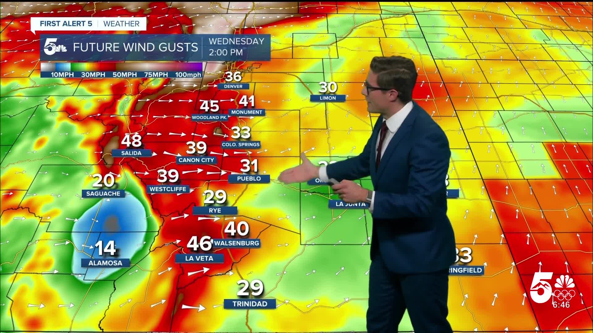
High Wind Warnings begin at 2 PM Wednesday and end at 3 AM Thursday. There will be wave clouds in the morning which dissipate by the afternoon. Clouds can reduce wind speeds because they can tamp down on mixing of the air. Wind will increase in the mountains by the morning commute but it won't get strong on I-25 until later. Wind speeds will progressively increase through the day, strongest during the afternoon and evening. Sustained winds of 30-40 mph, gusting to 60 mph are possible over most of the I-25 area. I expect stronger gusts over the Palmer Divide and in Teller County, as well as potentially the Wet Mountain Valley. Use caution if traveling over the Palmer Divide and across the area, particularly during the afternoon and evening.
We turn briefly cooler Thursday following the front, and stay breezy. We warm back up Friday and Saturday - with highs yet again returning to the 60s, and it will be gusty. Additional high fire danger days are possible Friday and Saturday, though the winds won't be as strong as Wednesday. A cold front will lead to a bit of a cooldown again on Sunday. Otherwise, Sunday through Tuesday keep above average temperatures with a bit less wind. These above average temperatures are likely to continue until early next year - and a white Christmas remains unlikely.
____
Curious about the First Alert 5 Weather Storm Impact Scale? Check out our cheatsheet explainer.
Watch KOAA News5 on your time, anytime with our free streaming app available for your Roku, FireTV, AppleTV and Android TV. Just search KOAA News5, download and start watching.
