


Today’s Forecast:
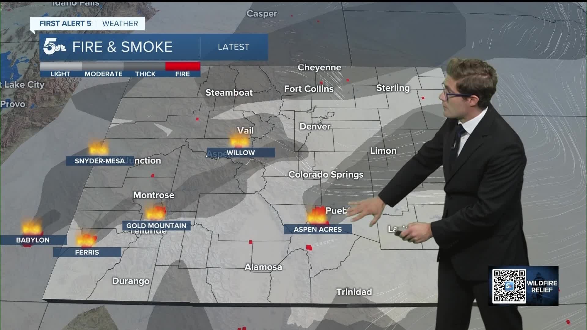
One final day of high fire danger awaits southern Colorado Friday, as we crank up the heat - today is likely to be the hottest day of the week. There will be periods of smoke once again. Air quality alerts currently extend through 9:00 AM but are very likely to be extended through the rest of the day. Avoid spending more time outside than needed today: wildfire smoke is bad for your heart and lungs.
Otherwise, expect sunny skies this morning with a few mid-level clouds this afternoon mainly in the foothills.
Colorado Springs forecast: High: 94; Low: 61.
RED FLAG WARNING in effect 10:00 AM - Midnight
It's going to be a HOT end to your week, in addition to the smokey skies and fire danger that returns today. Expect filtered sunshine behind the smoke, with increasing breezes this afternoon. Winds will be out of the southwest at 10-15 mph. They'll gust 25-30 mph this afternoon, and they will be more sporadic than what you've seen in recent days. It remains incredibly dry though, with humidity likely to once again drop to the single digits.
Pueblo forecast: High: 100; Low: 62.
RED FLAG WARNING in effect 10:00 AM - Midnight
Change is on the way, but it is not here yet. It's going to be very toasty today, with highs in the upper 90s to right around 100 this afternoon. Smoke from the Aspen Acres fire continues to be the main headline, and will impact the area through the entire day. Avoid spending more time outside than necessary under these conditions. Southwest winds at 10-15 mph, gusting to 30 mph this afternoon but relatively sporadic.
Canon City forecast: High: 98; Low: 62.
RED FLAG WARNING in effect 10:00 AM - Midnight
Sunny and very hot, with wildfire haze through the day but not as thick as within Pueblo itself. Still, avoid spending more time outside than necessary. West winds at 10-15 mph, gusting 25-30 mph this afternoon.
Woodland Park forecast: High: 84; Low: 48.
RED FLAG WARNING in effect 10:00 AM - Midnight
Smoke-filtered sunshine today, with continued high fire danger. Relief is ahead on the 4th, though there is some debate as to exactly how far west moisture will make it. In any case, today expect southwest winds at 10-15 mph, gusting to 30 mph this afternoon.
Tri-Lakes forecast: High: 80s; Low: 50s.
RED FLAG WARNING in effect 10:00 AM - Midnight
Sunny with patchy smoke from both the Gold Mountain and Aspen Acres fires. West winds at 10-15 mph, gusting 20-25 mph this afternoon.
Plains forecast: High: 90s/100s; Low: 60s.
Very hot, with periodic smoke, thickest of course directly downwind of the Aspen Acres fire where ash may fall. Otherwise, breezy with southwest winds at 10-20 mph, gusting to 30-35 mph this afternoon.
Walsenburg and Trinidad forecast: High: 93/96; Low: 58/59.
RED FLAG WARNING in effect 10:00 AM - Midnight
Patchy smoke, hot, and gusty. West winds at 10-20 mph, gusting to 35 mph this afternoon.
Mountains forecast: High: 80s; Low: 50s.
RED FLAG WARNING in effect 10:00 AM - Midnight
Smoke will continue to be thick today from the Aspen Acres wildfire. West winds at 10-20 mph, gusting to 30 mph after 11 AM.
Extended outlook forecast:
A frontal boundary pushes south overnight, and this brings in much higher dew points to southern Colorado. Dew points measure how wet or dry the air is: higher dew points mean more water is in the air. Isolated thunderstorms are possible in eastern Colorado on July 4th. From around the U.S. 24 line in Colorado Springs and areas northeast, these storms have the potential to be strong to severe — capable of large hail and damaging wind. This includes the Denver metro area. If you're headed to those areas on the 4th, stay weather aware. Storms are also possible further south along I-25, but are more conditional and will depend on outflow boundaries from other storms further north, or terrain (e.g. the mountains), to get going.
Otherwise, expect slightly cooler highs in the upper 80s to mid 90s on the 4th. The result of these storms, and the moisture increase, is a reduction in fire danger. It remains to be seen if we can get any wetting rain over the Aspen Acres fire, but at the least, humidity should rise.
Sunday will be slightly drier, with more "pop up" type thunderstorms across the plains, and highs quite similar to Saturday.
Isolated storm chances will continue through much of next week as a monsoon-like pattern takes shape. While I won't call this "the monsoon" just yet, the overall pattern features a large mid-level ridge, with southerly moisture streaming in underneath. Tuesday has the highest wetting rain potential of the next week at the moment in southern Colorado.
____
Curious about the First Alert 5 Weather Storm Impact Scale? Check out our cheatsheet explainer.
Watch KOAA News5 on your time, anytime with our free streaming app available for your Roku, FireTV, AppleTV and Android TV. Just search KOAA News5, download and start watching.
