

Today’s Forecast:
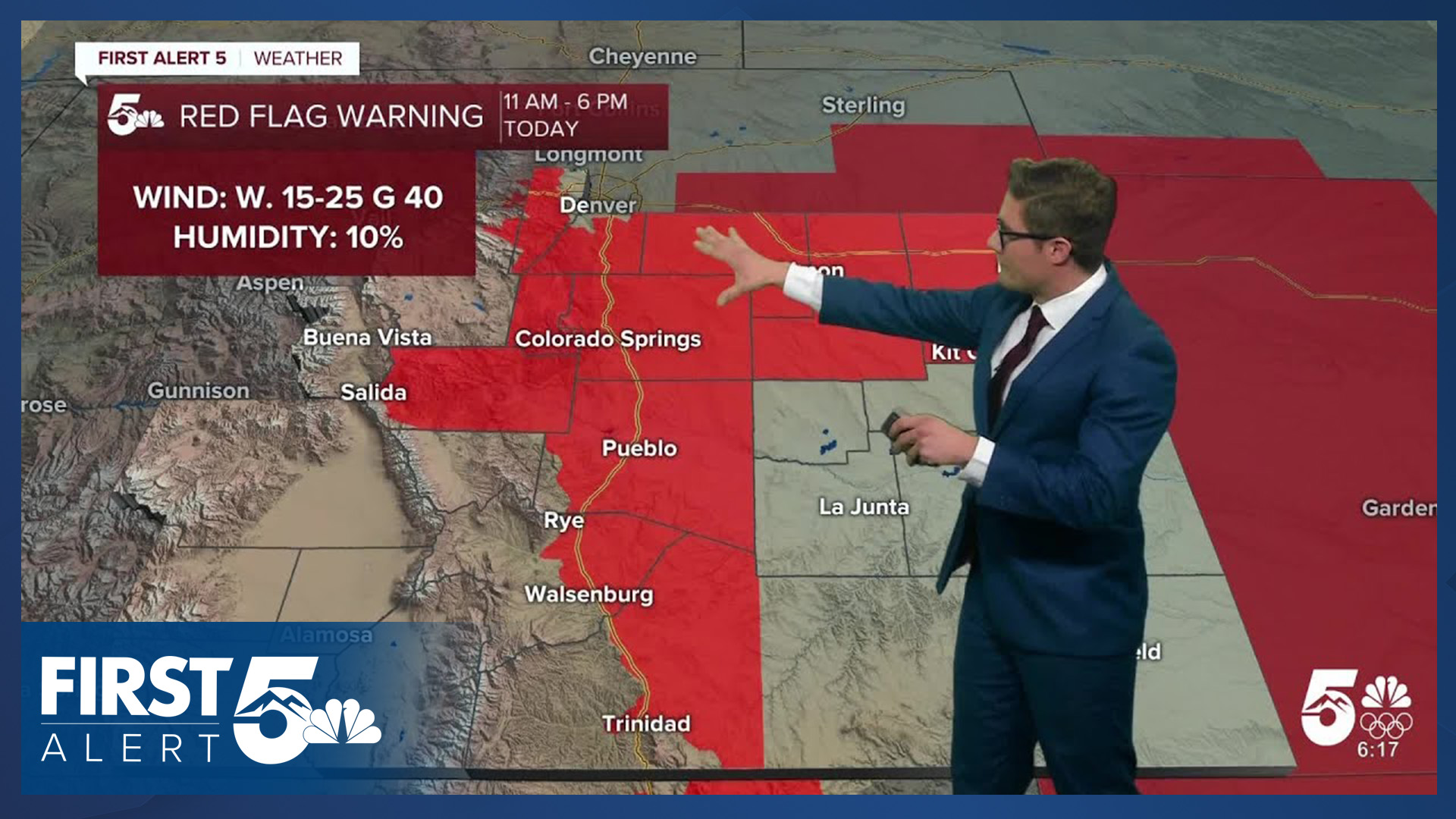
A very active week of weather begins today in southern Colorado as a fast jet stream roars overhead. Significant fire danger is the main concern. Red Flag Warnings cover the southern I-25 corridor today from 11:00 AM - 6:00 PM, plus Teller and Fremont counties.
Expect afternoon sustained winds of 15-25 mph from the west southwest, with gusts to 40 mph across portions of the area and slightly higher gusts in higher elevation zones, such as Teller County. Due to the downslope winds, it's already mild this morning - with temperatures starting in the 40s and 50s.
Highs today climb close to records. The record today in Colorado Springs is 68, and it is 73 in Pueblo. Humidity will drop to the low teens this afternoon, and our fuels are already dry. In fact, some data suggest parts of the southeastern plains are seeing their driest fuel conditions in a decade. It is very, very important to avoid outdoor burning this week, and anything that could generate a spark. This includes dragging vehicle chains, and even parking on tall grass. The bottom of your car is hot, and it can easily ignite dry fuels.
If you see smoke today, call 911. It shouldn't be there, and the faster emergency response is notified, the better their chance of getting a fire under control faster.
It's also a good idea to bring lightweight loose items inside tonight. Winds will be stronger tomorrow, they begin to increase before sunrise, and your favorite lawn chair could become your neighbor's if you don't.
Colorado Springs forecast: High: 67; Low: 37.
RED FLAG WARNING in effect from 11:00 AM - 6:00 PM MON
RED FLAG WARNING in effect from 10:00 AM - 7:00 PM TUE
Partly cloudy and warm today. The record high today in Colorado Springs is 68. Southwest winds west of I-25, south southwest winds east of I-25 sustained at 10-25 mph, gusting to 35-40 mph mainly this afternoon.
Pueblo forecast: High: 71; Low: 37.
RED FLAG WARNING in effect from 11:00 AM - 6:00 PM MON
RED FLAG WARNING in effect from 10:00 AM - 7:00 PM TUE
HIGH WIND WATCH in effect from 8:00 AM - 6:00 PM TUE
Mostly sunny with southwesterly winds increasing into mid-afternoon. Sustained wind speeds 10-30 mph, gusting to 40 mph.
Canon City forecast: High: 70; Low: 41.
RED FLAG WARNING in effect from 11:00 AM - 6:00 PM MON
HIGH WIND WATCH in effect from 8:00 AM - 6:00 PM TUE
Mostly sunny with southwest winds at 10-30 mph, gusting to 40 mph.
Woodland Park forecast: High: 59; Low: 30.
RED FLAG WARNING in effect from 11:00 AM - 6:00 PM MON
Mostly sunny. West southwest winds at 10-20 mph, increasing this afternoon to 15-25 mph with gusts at 30-35 mph. It will get windier tonight.
Tri-Lakes forecast: High: 60s; Low: 30s.
RED FLAG WARNING in effect from 11:00 AM - 6:00 PM MON
RED FLAG WARNING in effect from 10:00 AM - 7:00 PM TUE
Partly cloudy to mostly sunny due to periodic wave clouds, with south winds at 15-25 mph, gusting to 40 mph this afternoon.
Plains forecast: High: 60s/70s; Low: 30s/40s.
RED FLAG WARNING in effect from 10:00 AM - 7:00 PM TUE
HIGH WIND WATCH in effect from 8:00 AM - 6:00 PM TUE
Mostly sunny becoming partly cloudy this afternoon. West winds at 5-10 mph this morning. This afternoon winds will be southerly or southeasterly depending on your location and increase to 10-20 mph.
Walsenburg and Trinidad forecast: High: 68/71; Low: 42/40.
RED FLAG WARNING in effect from 11:00 AM - 6:00 PM MON
RED FLAG WARNING in effect from 10:00 AM - 7:00 PM TUE
HIGH WIND WATCH in effect from 8:00 AM - 6:00 PM TUE
Mostly sunny with southwest winds at 10-15 mph, increasing to 15-30 mph this afternoon, gusting to 45 mph.
Mountains forecast: High: 50s/60s; Low: 30s.
HIGH WIND WATCH in effect from 8:00 AM - 6:00 PM TUE
Partly cloudy with southwest winds at 10-25 mph, gusting to 35 mph this afternoon.
Extended outlook forecast:
A potent jet streak - a region of faster moving winds within the overall jet stream, will be directly over southern Colorado on Tuesday morning. This will result in notable downslope winds. Expect strong wind gusts close to the mountains —before sunrise —Tuesday. They will also keep temperatures very mild overnight. An elevated cold front will sweep east in the morning, and a brief period of wind-blown snow is possible in Teller County. A few additional snow squalls are possible Tuesday afternoon. While it isn't the main story, this will create commute impacts at times on Tuesday in the Woodland Park area.
The strong winds continue through the day Tuesday, with much of southern Colorado under a High Wind Watch. That does not include El Paso County. Winds on the southeastern plains will be sustained at 30-40 mph, gusting 60-70 mph. Red Flag Warnings are in place Tuesday for all of the plains of southeastern Colorado, from 10:00 AM - 7:00 PM.
At the moment, the potential limiting factor on fire risk Tuesday will be humidity. Following the cold front, temperatures will cool, and both absolute and relative humidity will increase. However, dry air quickly returns by the afternoon.
The combination of wind, dry air, and very dry fuels, make Tuesday a very high fire danger day. It is important to avoid any activity that could start a wildfire.
It remains breezy to gusty through Saturday, though the actual wind speeds and gusts do decrease each day from Wednesday to Saturday across southeastern Colorado. High fire danger continues through the rest of the week.
Moisture wise, beyond the quick shot of snow in Teller County that is possible Tuesday morning, snow squalls are possible in the afternoon. Additional snow is possible in Woodland Park on Wednesday.
Significant wind driven snow will fall tonight through Thursday across most of the mountains. It will be very difficult to travel over mountain passes and closures are likely.
Temperatures region-wide decline through the week as multiple fronts move through the area.
____
Curious about the First Alert 5 Weather Storm Impact Scale? Check out our cheatsheet explainer.
Watch KOAA News5 on your time, anytime with our free streaming app available for your Roku, FireTV, AppleTV and Android TV. Just search KOAA News5, download and start watching.
