

Tonight's Forecast:
The wind will gradually ease up tonight, but remain breezy from the west. This downsloping flow will help to keep temperatures mild overnight, with much of the region remaining above freezing.
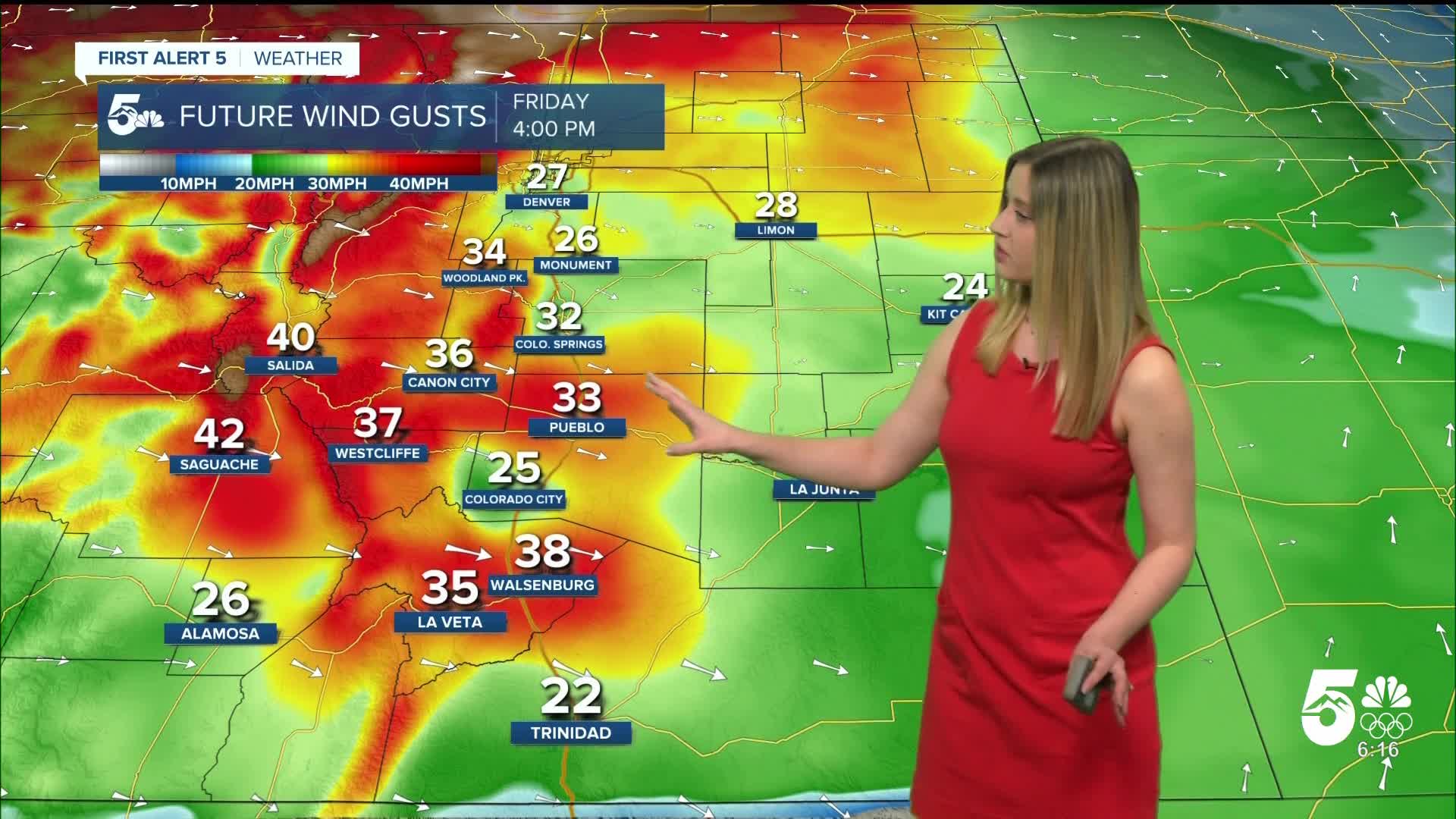
Friday Fire Danger:
Red Flag Warnings are in effect from 11 am until 8 pm for the zones highlighted in red. Do not create any sparks or flames outside. If you see smoke, call 911.

Colorado Springs forecast: Low: 39; High: 71;
RED FLAG WARNING 11 am until 8 pm. Wind will be out of the W at 15 mph gusting to 35 mph. The high temperature will be more than 15 degrees above average.
Pueblo forecast: Low: 41; High: 77;
RED FLAG WARNING 11 am until 8 pm. Wind will be out of the W at 15 mph gusting to 35 mph. It will be very warm and dry with relative humidity bottoming out at less than 10%.
Canon City forecast: Low: 41; High: 72;
RED FLAG WARNING 11 am until 8 pm. It will be a warm and dry day with gusty winds. Wind will be out of the W at 15 mph gusting to 40 mph.
Woodland Park forecast: Low: 34; High: 58;
It will be another gusty and mild day. Wind will be out of the W at 15-20 mph gusting to 35 mph.
Tri-Lakes forecast: Low: 39; High: 64;
RED FLAG WARNING 11 am until 8 pm. Warm and gusty on Friday with W wind at 15 mph gusting to 30 mph.
Plains forecast: Low: 30s-40s; High: 70s;
RED FLAG WARNING 11 am until 8 pm for the zones highlighted in red above. Wind will be breezy from the W, gusting to 25 mph outside of the red flag warning, and gusting to 35 mph inside the red flag warning.
Walsenburg and Trinidad forecast: Low: 42/37; High: 69/74;
RED FLAG WARNING 11 am until 8 pm. It will be a warm and dry day. Wind will be from the W at 10-15 mph, gusting to 40 mph in the Walsenburg vicinity, and 30 mph in the Trinidad vicinity.
Mountains forecast: Low: teens-30s; High: 50s-60s;
RED FLAG WARNING 11 am until 8 pm for the mountain zones highlighted in red above. It will be quite gusty again on Friday with W wind at 15-20 mph gusting 30-45 mph.
Extended outlook forecast:
Saturday will be even warmer and windier, with widespread gusts around 40-50 mph, lasting into the evening. A strong cold front blows in early on Sunday morning, bringing spotty light snow to the mountains as well as El Paso County. It will make for some slick spots in the morning on roads where snow falls. For everyone, it will be a blustery day with strong N wind.
____
Curious about the First Alert 5 Weather Storm Impact Scale? Check out our cheatsheet explainer.
Watch KOAA News5 on your time, anytime with our free streaming app available for your Roku, FireTV, AppleTV and Android TV. Just search KOAA News5, download and start watching.
