

Today’s Forecast:
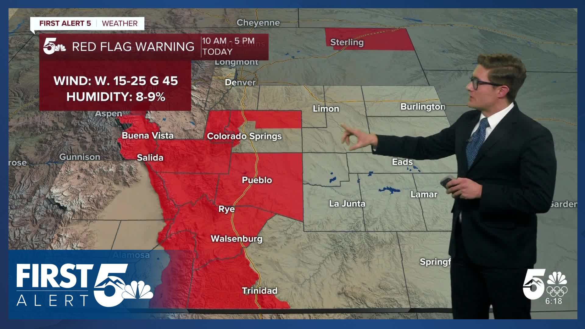
Red Flag Warnings will be widespread today in southern Colorado. The warnings begin at 10 AM and continue through 5 PM. Southern El Paso County including Colorado Springs is not included in the warning. Northern El Paso County, Teller County, and Fremont County are.
Although Colorado Springs is not included in the warning today due to marginal wind gust strength, it will still be dry, and somewhat breezy, so fire danger will still be elevated. It is important to avoid outdoor burning, and activities that could generate a spark (such as dragging vehicle chains), today along the southern I-25 corridor.
Skies will be partly cloudy due to periodic wave clouds. These clouds frequently form with a northwesterly fast upper level air flow and are an indicator of the potential for downslope wind.
The downslope breeze leads to warmth - today's highs will warm to the low 50s to low 60s, with Pueblo being one of the warmest spots. In fact, out the door temperatures in Colorado Springs are warmer than the high temperature reached on Monday. Colorado Springs reached 35 degrees for its Monday high temperature. Downslope breezes this morning mean the airport has been in the upper 30s.
Colorado Springs forecast: High: 53; Low: 17.
Mostly sunny this morning with increasing afternoon (wave) clouds. West winds at 10-15 mph, gusting to 20 mph. It will be dry and breezy today, but not as breezy as other parts of the southern I-25 corridor.
Pueblo forecast: High: 61; Low: 17.
RED FLAG WARNING from 10:00 AM - 5:00 PM
Downslope warmth on the way today, leading to high fire danger. Fuels are very dry across Pueblo county, humidity will be low this afternoon. Winds will be west at 10-30 mph gusting to 35 mph from late morning through at least 3:00 PM. Mostly sunny through mid-afternoon then increasing high clouds. Avoid activities that could start a fire.
Canon City forecast: High: 58; Low: 26.
RED FLAG WARNING from 10:00 AM - 5:00 PM
Mostly sunny and gusty. West winds at 10-25 mph, gusting to 40-45 mph this afternoon. This will result in high fire danger with low relative humidity. Patchy clouds tonight.
Woodland Park forecast: High: 47; Low: 19.
RED FLAG WARNING from 10:00 AM - 5:00 PM
Gusty with periodic mid-level clouds and fairly persistent high clouds. The high clouds will be very thin so they won't block the sunshine. West winds at 10-25 mph gusting to 45 mph. Avoid outdoor burning.
Tri-Lakes forecast: High: 50s; Low: Teens.
RED FLAG WARNING from 10:00 AM - 5:00 PM
Mostly sunny until mid-afternoon with west winds at 10-15 mph. Winds gust to 40 mph from 10 AM - late afternoon west of I-25. Wind gusts will periodically reach 30 mph east of I-25 this afternoon.
Plains forecast: High: 50s; Low: Teens.
Sunny and dry with west winds at 10-30 mph. While not under a Red Flag Warning, it will still be a dry day.
Walsenburg and Trinidad forecast: High: 54/58; Low: 21/17.
RED FLAG WARNING from 10:00 AM - 5:00 PM
Gap flow downslope breezes today in Huerfano county, slightly lighter in Las Animas county. Sunny with west winds at 10-30 mph, gusting to 40 mph.
Mountains forecast: High: 30s; Low: 10s/20s.
RED FLAG WARNING from 10:00 AM - 5:00 PM
Sunny, dry, and gusty. West winds at 10-15 mph increasing to 15-25 mph in the afternoon and gusting to 45 mph. Increasing clouds tonight.
Extended outlook forecast:
A cold front will push south this evening and will lead to a minor cooldown tomorrow. Airflow will be upslope over the plains and downslope close to the mountains. It's likely that the warmest temperatures Wednesday will be west of I-25, Overall highs should cool a few degrees under mainly clear skies.
Another weak cold push will arrive Wednesday night leading to a bit more cooling Thursday. It will remain breezy in the mountains but not on the plains.
We are continuing to track the potential for a winter weather maker Friday into Saturday. The latest trends are a bit slower, which suggests a time frame closer to Friday night or Saturday morning. Significant mountain snow remains likely. Across southern Colorado, snow totals of a couple of inches seem most likely. We are still nailing down timing and totals.
____
Curious about the First Alert 5 Weather Storm Impact Scale? Check out our cheatsheet explainer.
Watch KOAA News5 on your time, anytime with our free streaming app available for your Roku, FireTV, AppleTV and Android TV. Just search KOAA News5, download and start watching.
