


Tonight's Forecast:
It's been an exciting day so far, with thundersnow reported just before 5:30 pm south of Calhan. We should see a brief lull in the action this evening before a stronger wave of snow pushes into the Pikes Peak Region between 9-11 pm. As the storm intensifies, periods of snow and stronger winds will be possible through the overnight hours and into Sunday morning. Snow will be heavy at times from the Palmer Divide to Teller County. Travel in these areas and across the mountains is not recommended for the next 24-36 hours.
COLORADO SPRINGS: Low: 26; High: 34. The main challenge with the storm so far has been the warmer air. With below freezing temperatures expected tonight and more snow on the way, the snow should really start to pile up. Periods of snow will be possible through Sunday, along with strong northerly winds.

PUEBLO: Low: 29; High: 42. Periods of rain and snow will be possible through Sunday evening, with very light accumulations for both Pueblo and Pueblo West.
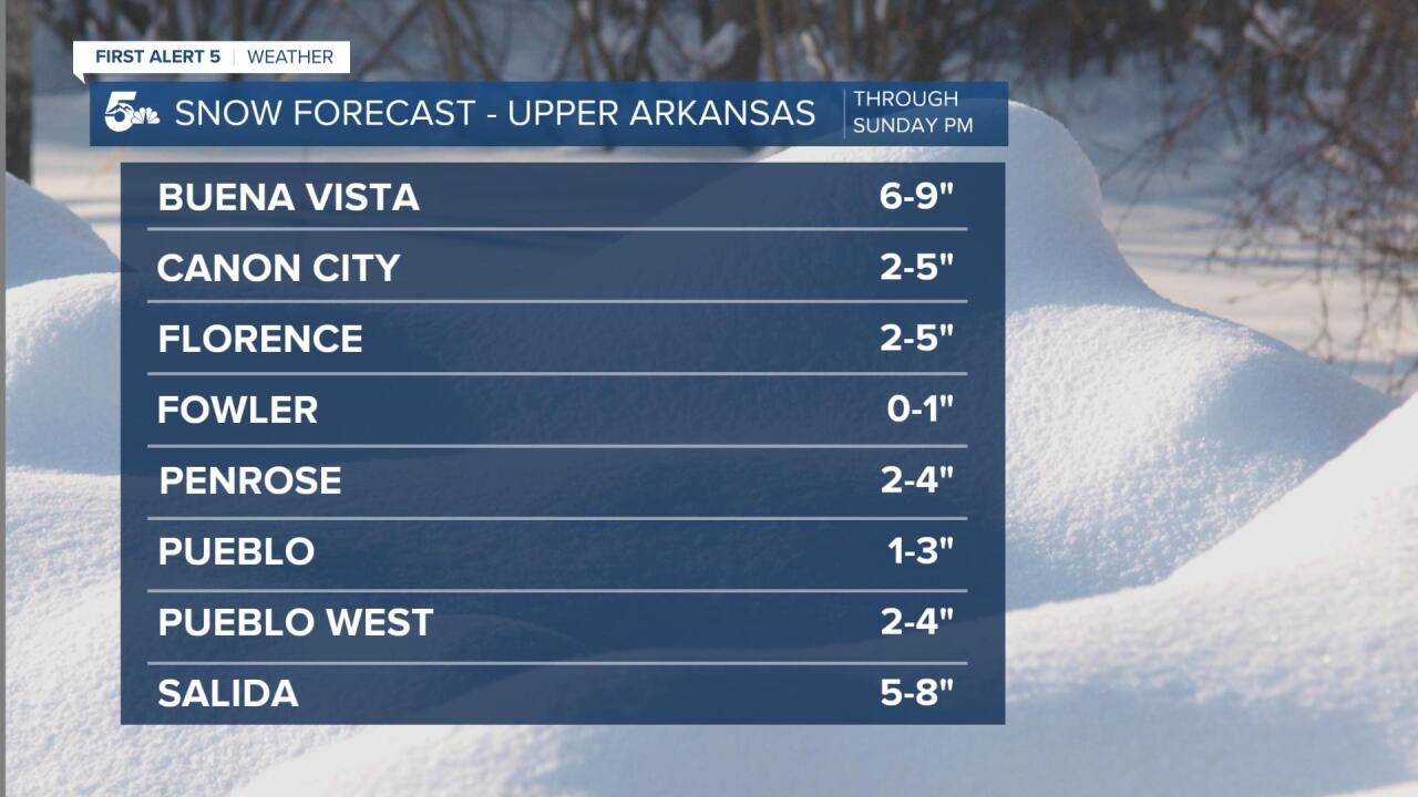
CANON CITY: Low: 30; High: 39. Snow will move through the forecast area in waves over the next 24 hours. Additional accumulations of 2-5" will be possible from Canon City east through Penrose.
WOODLAND PARK: Low: 22; High: 29. As far as local impacts, Teller County will pretty much be ground zero for this weekend's torm. Additional snowfall accumulations through Sunday night could total as high as 12-20" for Woodland Park.
TRI-LAKES: Low: 20s; High: 30s. Deteriorating conditions will take place across the Palmer Divide late tonight and continue through the day on Sunday, with the main course and dessert portion of the storm still to come. Additional snowfall totals of 10-18" are possible.
PLAINS: Low: 20s; High: 40s. Evening thunderstorms will give way to a few rain, or rain/snow showers on Sunday. Accumulations across the southeast Plains will be very minimal, with maybe 1" of snow possible around La Junta, Eads and Kit Carson.
WALSENBURG/TRINIDAD: Low: 20s; High: 30s/40s. Periods of snow will be possible through Sunday evening across the southern I-25 corridor. Additional snowfall totals in Walsenburg could reach 2-4", with 1-3" possible for Trinidad.
MOUNTAINS: Low: 0s/10s; High: 10s/20s. Snow and high winds may lead to treacherous driving conditions across the mountains through Sunday evening. The biggest totals are expected across the Pikes Peak area and into the Front Range mountains west of Denver. Several feet of snow could fall by Sunday night.
Extended Outlook:
Our large-scale, slow-moving winter storm will come to an end by early Monday morning. Tough drives will be left behind for the Monday morning commute as snow and ice will still be a problem on any untreated roadways. Monday's highs will be above freezing, with sunshine and snowmelt on tap for the afternoon. A quick-hitting storm will move out of the mountains Tuesday afternoon, with a light coating of snow and lower elevation rain possible Tuesday night and Wednesday morning.
KOAA News5 on your time, streaming on your Roku, FireTV, AppleTV and AndroidTV.
News5 App | First Alert 5 Weather App | Youtube | Facebook | Instagram | Twitter
