Today’s Forecast:
WINTER STORM WARNING in effect Sunday afternoon through Monday afternoon for EL PASO, TELLER, FREMONT, PUEBLO, CUSTER, HUERFANO, WESTERN LAS ANIMAS COUNTIES AND THE SAN LUIS VALLEY. These warnings extend into all of the Colorado mountains and northern Colorado front range.
WINTER WEATHER ADVISORY from Sunday evening through Monday evening for CROWLEY, OTERO, BENT, PROWERS, EASTERN LAS ANIMAS, AND BACA COUNTIES. This includes the northern Colorado eastern plains as well.
Scroll down for regional snow forecasts.
COLORADO SPRINGS: High: 26; Low: 4. Snow begins to ramp up after lunch and continue through Monday mid-day.
PUEBLO: High: 32; Low: 14. Cold today with snow showers ramping up this afternoon and lasting through Monday evening.
CANON CITY: High: 32; Low: 13. Snow increases through the morning and continues into mid-day Monday.
WOODLAND PARK: High: 22; Low: 1. Very cold with snow showers through Monday late morning.
TRI-LAKES: High: 20s; Low: single digits. Cold snow increasing through the morning and lasting through late morning Monday.
PLAINS: High: 30s; Low: teens. Snow starts this afternoon and tapers off through the evening Monday.
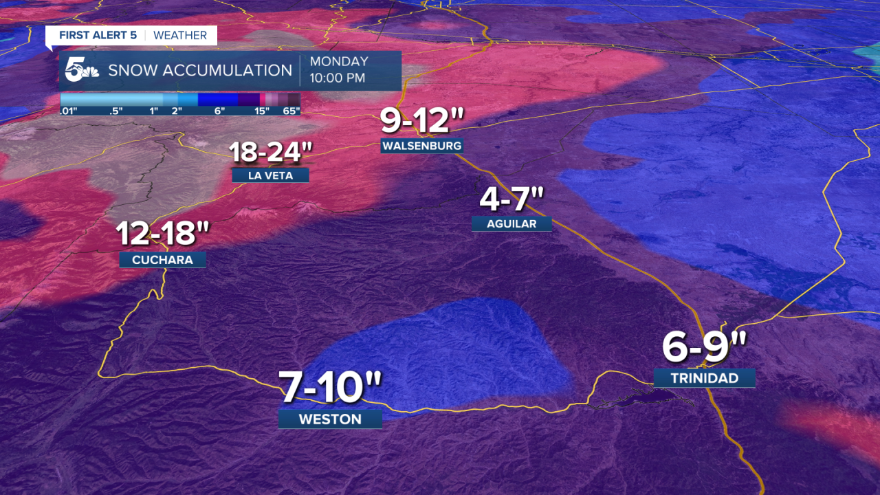
WALSENBURG/TRINIDAD: High: 30s; Low: single digits. Snow begins this evening, closer to dinner time, and lasts through Monday evening.
Extended Outlook:
The sky will clear out Monday night and it will be very cold in the single digits Tuesday morning. Highs on Tuesday will be in the teens and 20s. Temperatures finally rise above freezing Wednesday, and increase to the 60s by Halloween.
Regional Snow Forecast
Pikes Peak Region

Arkansas River and Wet Mountains

Southern I-25 and Southern Sangre De Cristos