



Today’s Forecast:
After some much needed rainfall yesterday, we'll see a rinse and repeat pattern today, thanks to an active monsoon weather pattern. The monsoon refers to increasing moisture from the Gulf and Pacific Ocean. It's a seasonal shift in the wind that helps to bring Southern Colorado around a third of our average yearly rainfall during the late summer months.
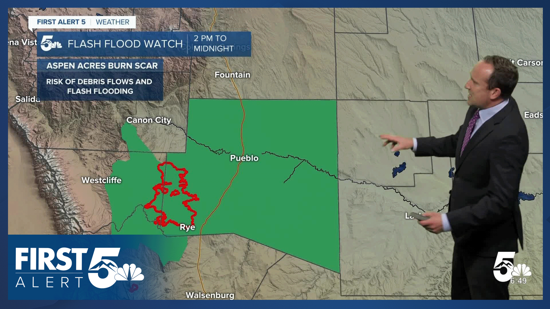
Rain showers and thunderstorms will form in the high country towards the late morning hours, with storms moving east into the Plains. Multiple waves of rain will be possible region-wide today, with rain ending during the evening hours from north to south. To add to the mix, an incoming disturbance currently over Utah will help with extra energy for today's storms, allowing for areas of heavy rain in Southern Colorado. A risk of urban and burn scar flooding will be elevated today, especially around the Aspen Acres fire zone and burn scar. In this area, rainfall rates of around 0.25" per hour will trigger Flash Flood Warnings. This is very easy to achieve, and we're expecting to see multiple warnings today in the fire zone.

Colorado Springs forecast: High: 87; Low: 62. After four days in a row in the 90s, we'll see a small reprieve from the heat today as our high warms to near average, topping out in the upper 80s. The main reason for the cool down will be the rain, with numerous showers and thunderstorms this afternoon and evening. Pockets of heavy rain will be possible.
Pueblo forecast: High: 97; Low: 66. We managed to see some much needed rainfall back on Wednesday and more is on the way today. Showers and storms will become more numerous after 1 or 2 pm, with multiple rounds of rain continuing into the evening hours.
Canon City forecast: High: 93; Low: 63. An active monsoon weather pattern on Thursday will bring us increasing chances for thunderstorms and heavy downpours this afternoon and evening. Periods of heavy rain could lead to flooding in some areas.
Woodland Park forecast: High: 78; Low: 54. It will be dry when you head out the door this morning, but the dry skies won't last long. Rain showers start to form ahead of the lunch hour, with periods of rain and thunderstorms up to the dinner hour this evening.
Tri-Lakes forecast: High: 80s; Low: 50s/60s. The well advertised monsoon arrived yesterday, with more of the same on tap today for the Palmer Divide. Today's storms will bring the potential for heavy rainfall, frequent lightning, gusty winds and small hail.
Plains forecast: High: 90s/100s; Low: 60s. Many of us on the Plains missed out on the rain on Wednesday, but that shouldn't be the case today as a disturbance coming out of Utah will bring us better chances for rain this afternoon and evening. Some storms could turn severe today, with 1" hail and 60 mph gusts.
Walsenburg and Trinidad forecast: High: 90s; Low: 60s. With the peak of the monsoon this afternoon, we should see increasing chances for rain today across the southern I-25 corridor. Rain will begin to develop towards the early to mid afternoon hours.
Mountains forecast: High: 60s/70s; Low: 40s/50s. Storms will pulse up early today in the mountains, with some areas seeing rain by late this morning. Today's threats will include heavy rain and burn scar flooding, small stream and creek flooding, frequent lightning, and gusty winds.
Extended outlook forecast:
The monsoon moisture gets "cut off" starting on Friday as high pressure builds back towards Colorado. Recycled moisture trapped underneath the high pressure system will help to spark mountain showers and thunderstorms Friday afternoon, with a few storms possible in the Pikes Peak Region. Our high on Friday will warm back up to the lower 90s.
The heat will continue to build this weekend, with middle 90s Saturday and upper 90s by Sunday. Storms should be isolated this weekend in the Pikes Peak Region, again mainly focused near the higher terrain.
Records will be possible in Colorado Springs both Sunday and Monday, and it will be hot! Monsoon moisture is expected to return towards the early to middle parts of next week, with growing chances for rain across Southern Colorado.
____
Curious about the First Alert 5 Weather Storm Impact Scale? Check out our cheatsheet explainer.
Watch KOAA News5 on your time, anytime with our free streaming app available for your Roku, FireTV, AppleTV and Android TV. Just search KOAA News5, download and start watching.
