


Tonight's Forecast:
Out ahead of some major changes to our forecast beginning Wednesday night, our weather tonight will be on the quiet side. For the I-25 corridor and Plains, we'll see increasing clouds push into the region after midnight, but no rain or snow is expected.
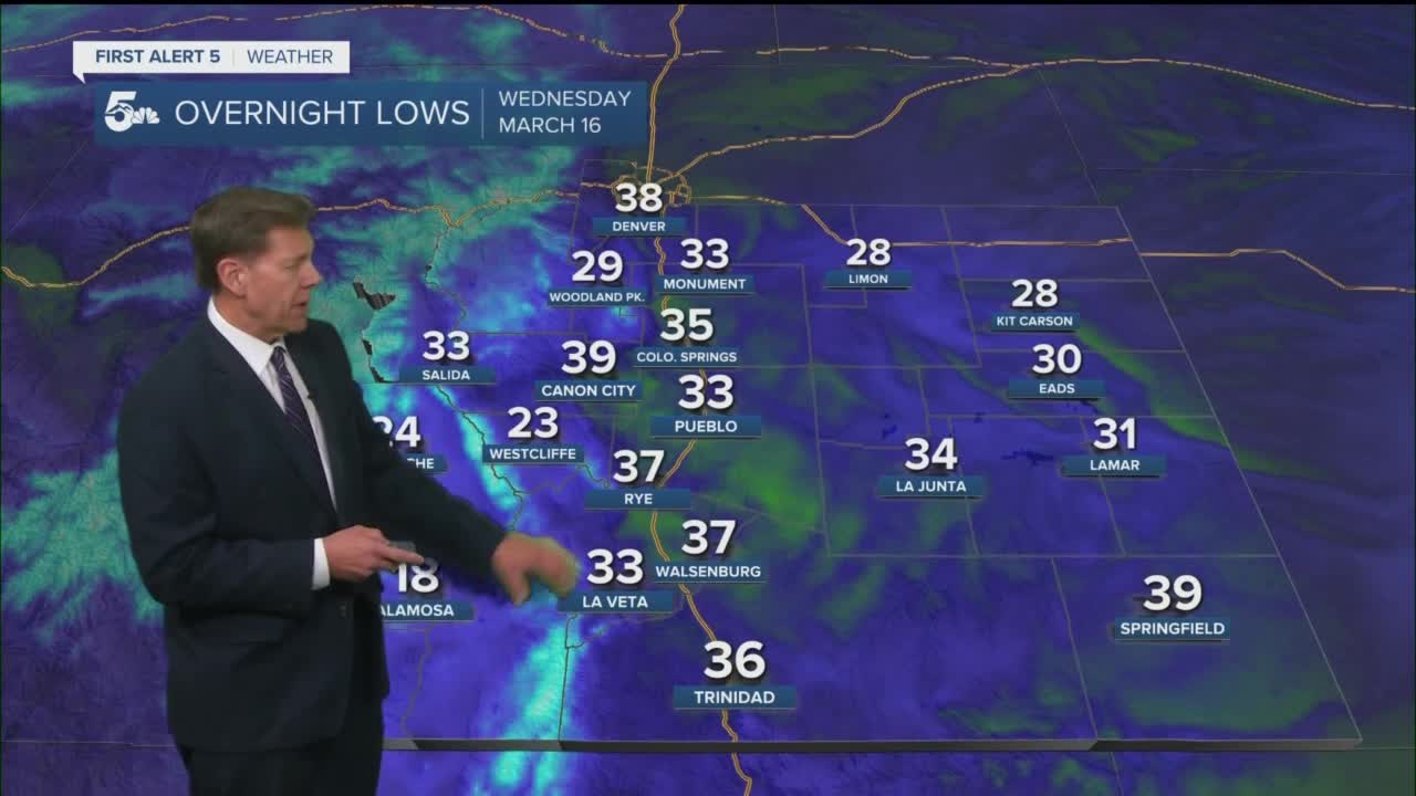
Colorado Springs forecast: Low: 35; High: 57; We'll be dry for most of the daylight hours on Wednesday before rain begins to push into the region around sunset. With snow levels up near 7,000 feet at the onset of the storm, rain won't likely changeover to snow until closer to 9-11 pm as colder air drops in from the north.
Pueblo forecast: Low: 33; High: 64; Dry and mild during the day before rain moves into the forecast after sunset. An overnight changeover to snow is expected to occur, but with temperatures hovering near the freezing mark, accumulations in the Pueblo area should mainly stay on grassy surfaces, rooftops, trees and cars.
Canon City forecast: Low: 39; High: 62; Dry during the day before turning wet and unsettled after sunset. Much like Pueblo, rain won't changeover to snow until after midnight when the colder air arrives.
Woodland Park forecast: Low: 29; High: 49; A Winter Storm Watch will go into effect in Teller County at 6 pm as snow begins to develop. Heavier snow bands will be possible into the overnight hours and through the first part of the day on Thursday.
Tri-Lakes forecast: Low: 20s/30s; High: 50s; A Winter Storm Watch will go into effect at 6 pm for northern parts of El Paso County. Snow will be heavy at times from late Wednesday night into midday Thursday, with totals up near a foot along parts of the Palmer Divide.
Plains forecast: Low: 30s; High: 60s; Dry during the day before a good soaking rain moves into the Plains by Wednesday night. A brief changeover to a heavy, wet snow will be possible during the overnight hours, but not much accumulation is expected as temperatures won't hover near the freezing mark for very long.
Walsenburg and Trinidad forecast: Low: 30s; High: 50s/60s; Most of our Wednesday will be dry as moisture from the storm isn't expected to reach the southern I-25 corridor until closer to midnight. What starts out as rain will change to snow during the overnight hours, with snow likely into midday Thursday.
Mountains forecast: Low: 20s/30s; High: 30s/40s; Big totals are expected for the mountains as both the Wets and Sangres will be under a Winter Weather Advisory from Wednesday evening to Thursday evening. Plan ahead as mountain travel will become difficult after sunset tomorrow.
Extended outlook forecast:
After a slushy and slick commute Thursday morning, we'll stay wintry through at least midday Thursday as the storm slowly clears out from north to south. The highest totals will be for areas above 6,500 feet. Below that, warmer air and rain at the onset of the storm will have a big impact on what can accumulate. For the Plains below 5,500 feet, our roads should stay wet throughout a majority of the storm, with any accumulations likely to collect on grassy surfaces and such.
A transition to warmer weather is expected this weekend before the potential for a windy and wintry mess returns to the forecast early next week.
____
Curious about the First Alert 5 Weather Storm Impact Scale? Check out our cheatsheet explainer.
Watch KOAA News5 on your time, anytime with our free streaming app available for your Roku, FireTV, AppleTV and Android TV. Just search KOAA News5, download and start watching.