


Tonight's Forecast:
The big story tonight will be the threat for heavy rainfall and flooding across Southern Colorado, with Flood Watches covering a large portion of the forecast area through 3 am. This includes the entire I-25 corridor from the Wyoming state line down to the New Mexico state line. Some areas could see as much as 1-3" of rain, although those higher totals will likely be more localized in nature.
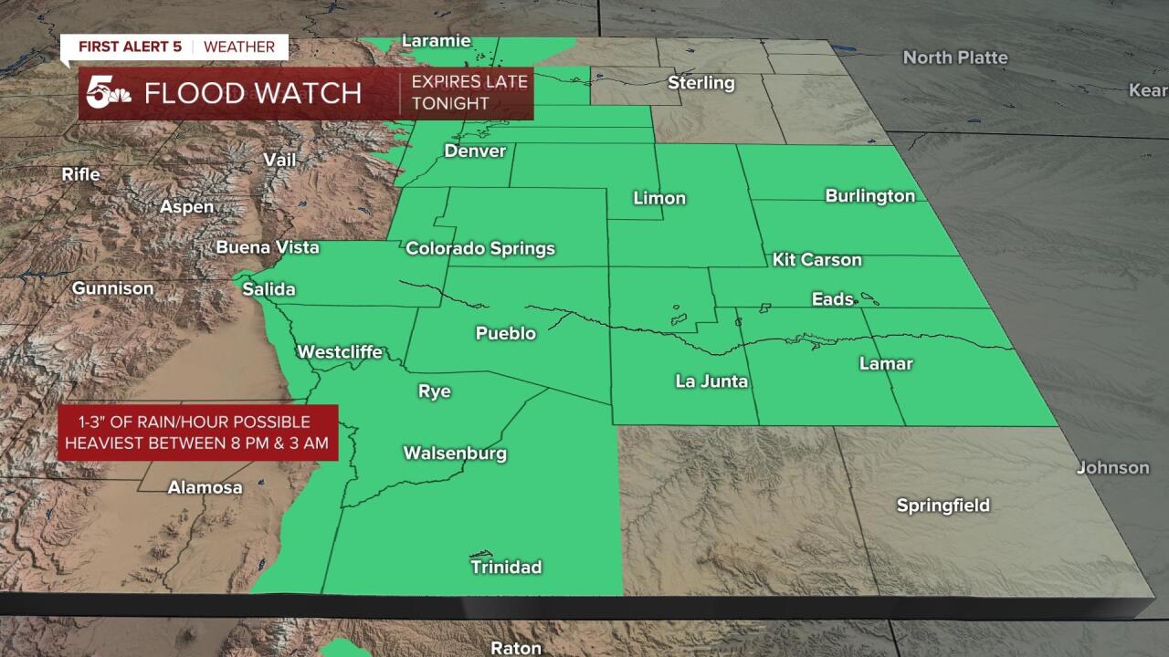
Rain should wind down before sunrise Monday, with the flood threat coming to an end before the morning rush hour drive to work.
Colorado Springs forecast: Low: 58; High: 78; The heaviest rain should come to an end well before sunrise on Monday, leaving with with a partly cloudy start to our day. By the afternoon, recycled moisture from Sunday night could generate a few passing thunderstorms.
Pueblo forecast: Low: 61; High: 83; Dry skies are slated for the morning hours on Monday, followed by the potential for a few isolated to scattered afternoon thunderstorms.
Canon City forecast: Low: 62; High: 82; With the threat for heavy rain coming to an end before sunrise Monday morning, we'll be left with a dry start to the day. A few more scattered afternoon thunderstorms will be possible tomorrow afternoon/early evening.
Woodland Park forecast: Low: 52; High: 71; After a mellow morning, we're expecting to see scattered showers and thunderstorms return to parts of Teller County by Monday afternoon and evening.
Tri-Lakes forecast: Low: 50s; High: 70s; A cooler start to the work week can be expected for the Palmer Divide as dry skies early will give way to the potential for scattered late day showers and thunderstorms.
Plains forecast: Low: 60s; High: 80s; After heavy overnight rain, dry skies Monday morning will give way to a few widely scattered showers and thunderstorms by Monday afternoon. Unlike today, severe weather is not expected to be a big concern.
Walsenburg and Trinidad forecast: Low: 50s; High: 70s/80s; Heavy overnight rain will remain a concern across the southern I-25 corridor and Raton Mesa region. By daybreak Monday, the rain should come to an end, but it won't last long as scattered thunderstorms are likely to return by the afternoon hours.
Mountains forecast: Low: 40s/50s; High: 60s; With leftover monsoonal moisture in place on Monday, we'll continue to see the potential for showers and thunderstorms over the mountains, along with a small risk for burn scar flooding. Be Weather Ready to take action if an alert is issued in your area!
Extended outlook forecast:
High pressure expanding back towards Colorado will shut off the monsoon flow to the Plains starting on Tuesday, leading to a drier and warmer afternoon. This trend will continue throughout the rest of the week, with a gradual warming trend and partly cloudy, but dry afternoons. During this time, isolated to scattered thunderstorms will remain a constant over the mountains and mountain valleys, but storm chances won't return to the Plains until the weekend.
____
Curious about the First Alert 5 Weather Storm Impact Scale? Check out our cheatsheet explainer.
Watch KOAA News5 on your time, anytime with our free streaming app available for your Roku, FireTV, AppleTV and Android TV. Just search KOAA News5, download and start watching.
