



Today’s Forecast:
We're looking at our fifth day in a row with highs in the 90s and 100s, with temperatures in Southern Colorado this afternoon running at around 8-12 degrees above average. We came up just short of records in the Springs and Pueblo on Monday, topping out at 94°F and 100°F respectively. Today's records look safe in both cities, but with the heat back this afternoon, another round of Heat Advisories has been issued for El Paso, Pueblo, and eastern Fremont counties.

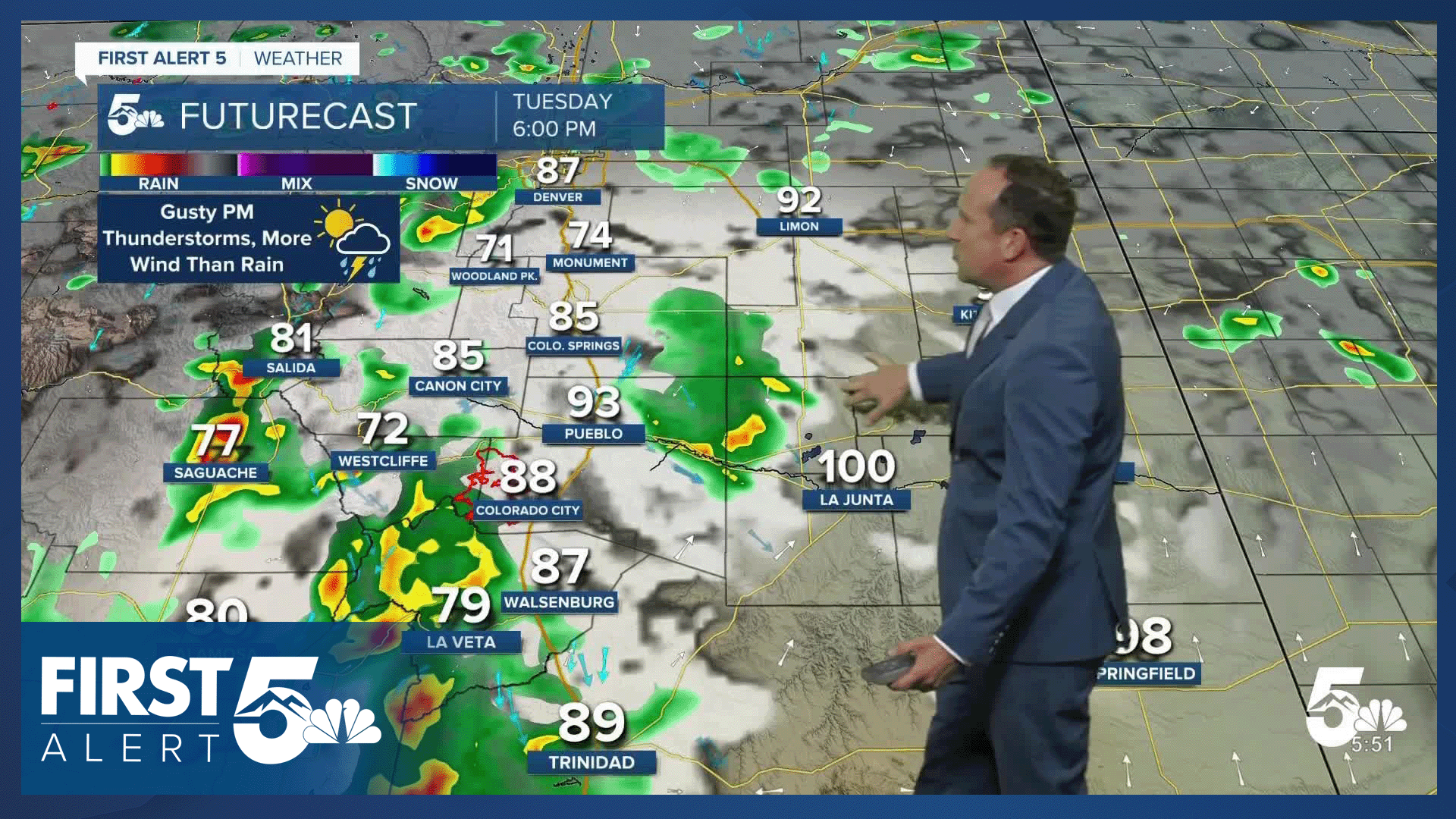
Much like yesterday, there will be enough high-based moisture to lead to spotty thunderstorms this afternoon. With dry air at the surface, storms on the Plains will produce more wind than rain. Some areas may also see rain today, with chances for wet weather highest over the mountains.
Colorado Springs forecast: High: 94; Low: 62. A HEAT ADVISORY will go into effect at 11 am, and continue until 7 pm. More dry thunderstorms will be possible today, anytime after 3-4 pm, with more wind than rain for the Pikes Peak Region.
Pueblo forecast: High: 101; Low: 65. Tuesday will bring another day of heat to Pueblo County, with a HEAT ADVISORY in effect from 11 am to 7 pm. Thunderstorms will be possible this afternoon, with more wind than rain due to dry air at the surface.
Canon City forecast: High: 98; Low: 65. It's going to be another hot day in eastern Fremont County, where a HEAT ADVISORY will go back into effect starting at 11 am. Isolated to scattered storms will be possible this afternoon after 2-3 pm, with gusty winds the main storm threat.
Woodland Park forecast: High: 84; Low: 54. Mostly sunny skies this morning will give way to a warm afternoon, with scattered thunderstorms in Teller County.
Tri-Lakes forecast: High: 80s/90s; Low: 50s/60s. Hot weather will continue on Tuesday, with perhaps a few cooling showers this afternoon in some neighborhoods. Storms will mainly be dry in the lower elevations, with gusty wind the main threat.
Plains forecast: High: 90s/100s; Low: 60s/70s. Tuesday's forecast will be hot and mainly dry on the Plains, with precipitation chances dropping off today before picking back up late this week.
Walsenburg and Trinidad forecast: High: 90s; Low: 50s/60s. Along with the heat, we should see mainly dry conditions on Tuesday, with only a slight chance of showers and thunderstorms this afternoon.
Mountains forecast: High: 70s/80s; Low: 40s/50s. Dry skies this morning, with scattered showers and thunderstorms this afternoon. Storms look to pulse up between 12-2 pm, and will mostly diminish before sunset this evening.
Extended outlook forecast:
As the moisture plume over Arizona shifts towards Colorado, we will see increasing chances for rain from Wednesday to Sunday. I see Wednesday as more of a transition day. Yes, it will still be hot, but storms will become more widespread towards the afternoon hours.
Heavy rain producing thunderstorms will be possible both Thursday and Friday. Storms will favor the afternoon to evening hours, with potential flood threats also increasing in poor drainage areas, as well as recent burn scars. The Aspen Acres burn scar will be at real risk for flash flooding and debris flows starting on Thursday, with daily threats here through the weekend.
Highs will warm into the lower 80s in Colorado Springs each afternoon from Thursday into the weekend, with scattered afternoon thunderstorms also possible each day.
____
Curious about the First Alert 5 Weather Storm Impact Scale? Check out our cheatsheet explainer.
Watch KOAA News5 on your time, anytime with our free streaming app available for your Roku, FireTV, AppleTV and Android TV. Just search KOAA News5, download and start watching.
