


Today’s Forecast:
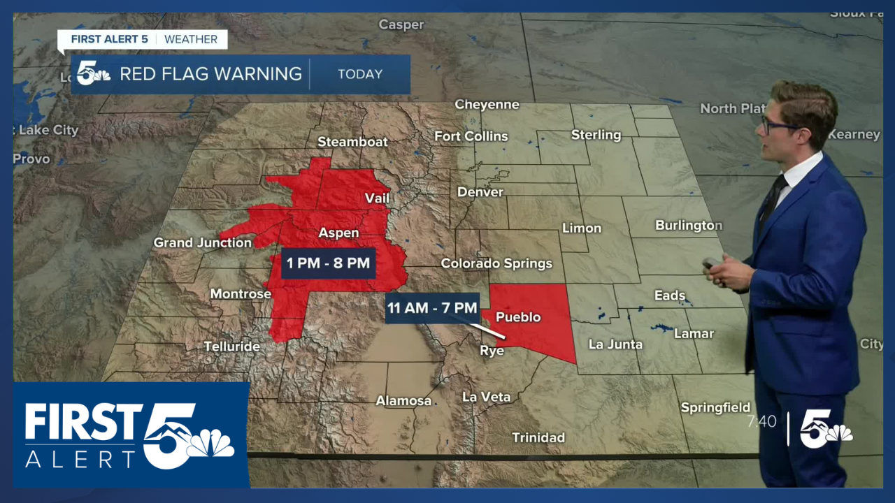
The heat continues Saturday in southern Colorado with many areas warming to the 90s, and the rest of us reaching the 80s. High fire danger continues as well, with Pueblo County under a Red Flag Warning today.
Colorado Springs forecast: High: 85; Low: 51.
Warm today in Colorado Springs, just a couple degrees cooler than Friday. If you're going to the Pride Festival, expect temperatures in the middle to upper 80s this afternoon. Winds will be northwesterly at 5-15 mph this morning. Following two frontal boundaries, winds shift northeasterly this afternoon and increase to 15-25 mph. Skies become mostly cloudy tonight.
Pueblo forecast: High: 94; Low: 58.
RED FLAG WARNING in effect from 11:00 AM - 7:00 PM
Hot and dry today as temperatures rapidly climb into the afternoon. Increasing clouds after 3:00 PM. Northwest winds at 10-20 mph this morning, shifting north northeasterly this afternoon at 15-25 mph. Avoid outdoor burning today!
Canon City forecast: High: 94; Low: 55.
Another toasty day! Mostly sunny this morning, with increasing clouds after 2:00 PM and eventually becoming mostly cloudy. Thankfully the wind will be lighter today so fire threats will be lower. That said, it will still be very dry, so exercise caution and be mindful of activities that could start a fire. West winds at 10-15 mph.
Woodland Park forecast: High: 77; Low: 44.
Mostly sunny this morning, partly cloudy this afternoon. An isolated afternoon shower or thunderstorm is possible - primarily terrain driven today so these would favor places like Divide, Midland, Florissant, or Pikes Peak itself. Northwest winds at 10-15 mph.
Tri-Lakes forecast: High: 70s; Low: 40s.
Sunny before 3:00 PM, then becoming partly and eventually mostly cloudy. Breezy! North winds at 10-20 mph this morning, shifting north northeast at 15-25 mph this afternoon.
Plains forecast: High: 80s/90s; Low: 50s.
Hot! And mostly sunny and breezy, too. West winds at 10-20 mph, shifting north at 15-25 mph through the morning as a front swings south, gusting to 40 mph.
Walsenburg and Trinidad forecast: High: 89/90; Low: 54/51.
Lighter wind today, but still dry and hot. Mostly sunny with west winds at 10-15 mph.
Mountains forecast: High: 80s; Low: 40s/50s.
Mostly sunny this morning, with isolated showers and thunderstorms this afternoon (timing favors south to north progression). West winds at 10-15 mph.
Extended outlook forecast:
Sunday will be cool, cloudy, and rainy with a chance of light rain showers in the morning on the plains and southern mountains, with thunderstorms in the afternoon. Thunder chances are greatest west of I-25. Highs will be well below average. Given the heat this week and next week though, that might not be a bad thing. Isolated PM thunderstorms are still possible Monday in the Pikes Peak Region.
Hot and dry conditions return mid-week, with mid-90s possible by Wednesday, and more fire danger possible.
____
Curious about the First Alert 5 Weather Storm Impact Scale? Check out our cheatsheet explainer.
Watch KOAA News5 on your time, anytime with our free streaming app available for your Roku, FireTV, AppleTV and Android TV. Just search KOAA News5, download and start watching.
