

Today’s Forecast:
Heat Advisories are active today again from 11:00 AM - 8:00 PM. Highs today will be in the middle 90s again, with a mix of sun, clouds, and haze. It will also be gusty, with downslope winds in the afternoon gusting between 25-35 mph from the west. This will elevate fire danger today across the Pikes Peak Region. While we are not under Red Flag Warnings, it's still a day to be mindful of things that could start a wildfire.
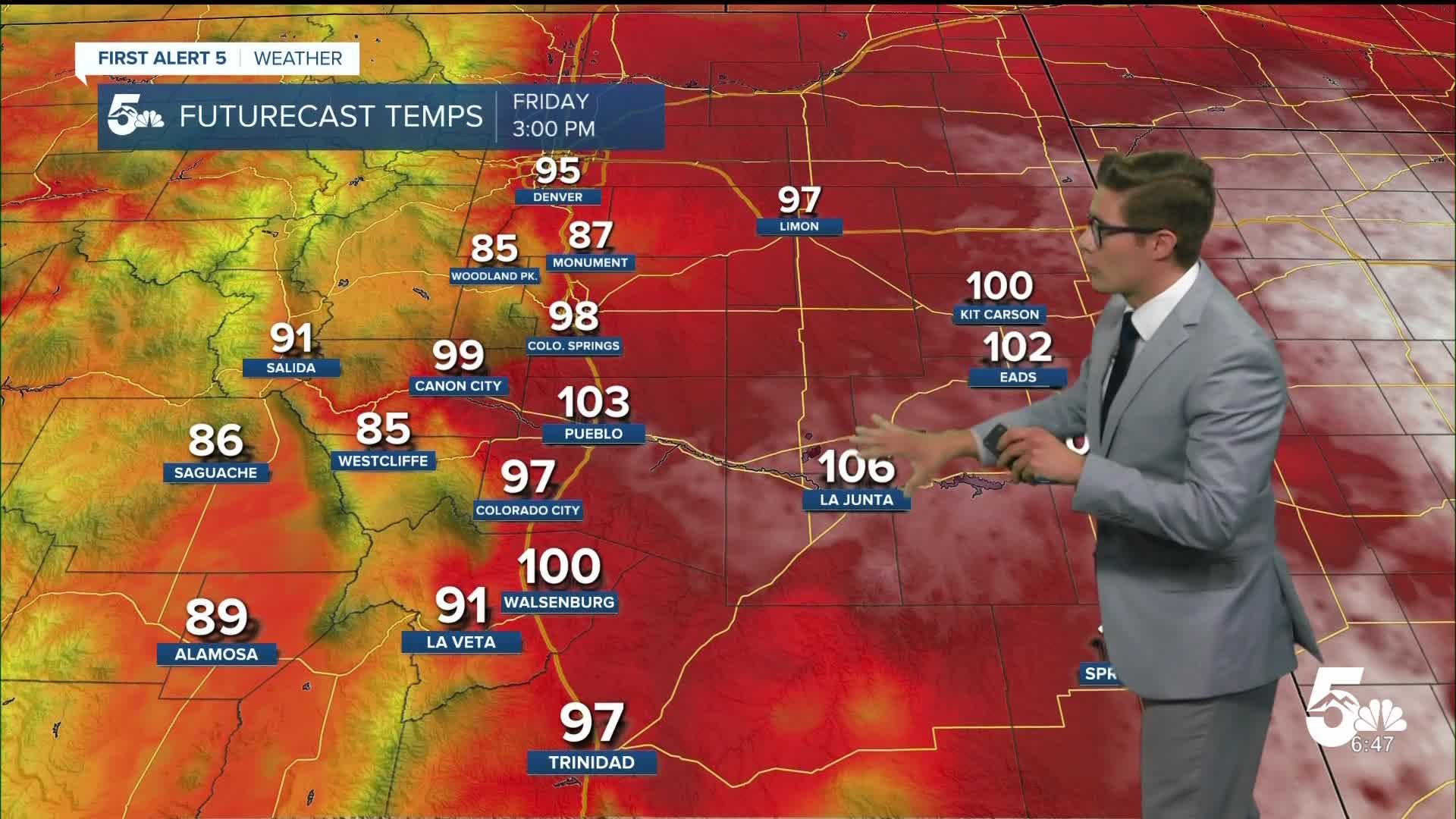
Colorado Springs forecast: High: 95; Low: 57.
HEAT ADVISORY in effect from 11:00 AM - 8:00 PM
Mostly sunny, hazy at times, and very hot. West winds at 10-20 mph, gusting to 35 mph this afternoon. Fire danger is elevated today - even though we are not in a Red Flag Warning. Please be mindful of outdoor burning, vehicle chains, and anything else that could start a spark or fire. Increasing clouds this afternoon.
Pueblo forecast: High: 102; Low: 61.
HEAT ADVISORY in effect from 11:00 AM - 8:00 PM
Not hot enough to melt steel - but plenty hot enough to spend the day inside (if you can)! Mostly sunny, hazy, and hot! West winds at 10-20 mph this morning, increasing to 20-30 mph this afternoon, gusting to 35 mph. This will elevate fire danger. Please be mindful of anything that could generate a spark or fire.
Canon City forecast: High: 97; Low: 61.
HEAT ADVISORY in effect from 11:00 AM - 8:00 PM
RED FLAG WARNING in effect from 11:00 AM - 8:00 PM
Patchy clouds, and haze, with increasing clouds this afternoon. West winds at 10-20 mph, gusting to 30 mph this afternoon.
Woodland Park forecast: High: 83; Low: 48.
Mostly sunny and very warm. Light smoke at times but better than the last few days. Windy - with winds this morning at 5-15 mph, increasing to 15-25 mph this afternoon and gusting to 35 mph. Increasing afternoon clouds.
Tri-Lakes forecast: High: 80s; Low: 50s.
HEAT ADVISORY in effect from 11:00 AM - 8:00 PM
Mostly sunny and very hot. West winds at 10-20 mph, gusting to 30 mph this afternoon.
Plains forecast: High: 100s; Low: 60s.
HEAT ADVISORY in effect from 11:00 AM - 8:00 PM - lower Arkansas River Valley ONLY
Hazy and very hot. West winds at 15-20 mph, gusting to 25-30 mph this afternoon.
Walsenburg and Trinidad forecast: High: 98; Low: 59/58.
Hazy with patchy clouds. Gusty. West winds at 10-20 mph, gusting to 35 mph this afternoon.
Mountains forecast: High: 80s; Low: 50s.
Hazy with patchy morning clouds becoming mostly cloudy in the afternoon. Windy. West winds at 15-25 mph, increasing to 20-30 mph in the afternoon gusting to 40 mph.
Extended outlook forecast:
A cold front arrives tonight. It'll be dry, but it will be noticeable with a sudden burst of gusty northerly wind when it reaches your home. It will bring in upslope flow that continues Saturday, and provide an area of focus for storm development.
Storms tomorrow will be isolated, but strong. Severe weather threats exist on the eastern plains, with isolated threats along the urban corridor mainly north of highway 50. Otherwise, expect cooler highs Saturday, and less smoke in the air.
Storms continue Sunday, and temperatures cool further with a secondary push of "cool" air. Severe weather threats should be lower - a couple severe storms are still possible, as is often the case in southern Colorado, but the organization for widespread severe weather is not as favorable.
Much of next week returns to sunny and hot - but not the same oppressive, dangerous, heat that we've seen at the end of this week.
____
Curious about the First Alert 5 Weather Storm Impact Scale? Check out our cheatsheet explainer.
Watch KOAA News5 on your time, anytime with our free streaming app available for your Roku, FireTV, AppleTV and Android TV. Just search KOAA News5, download and start watching.
