

Tonight's Forecast:
It will remain mild overnight with a light breeze across the region. The sky will be mostly clear.
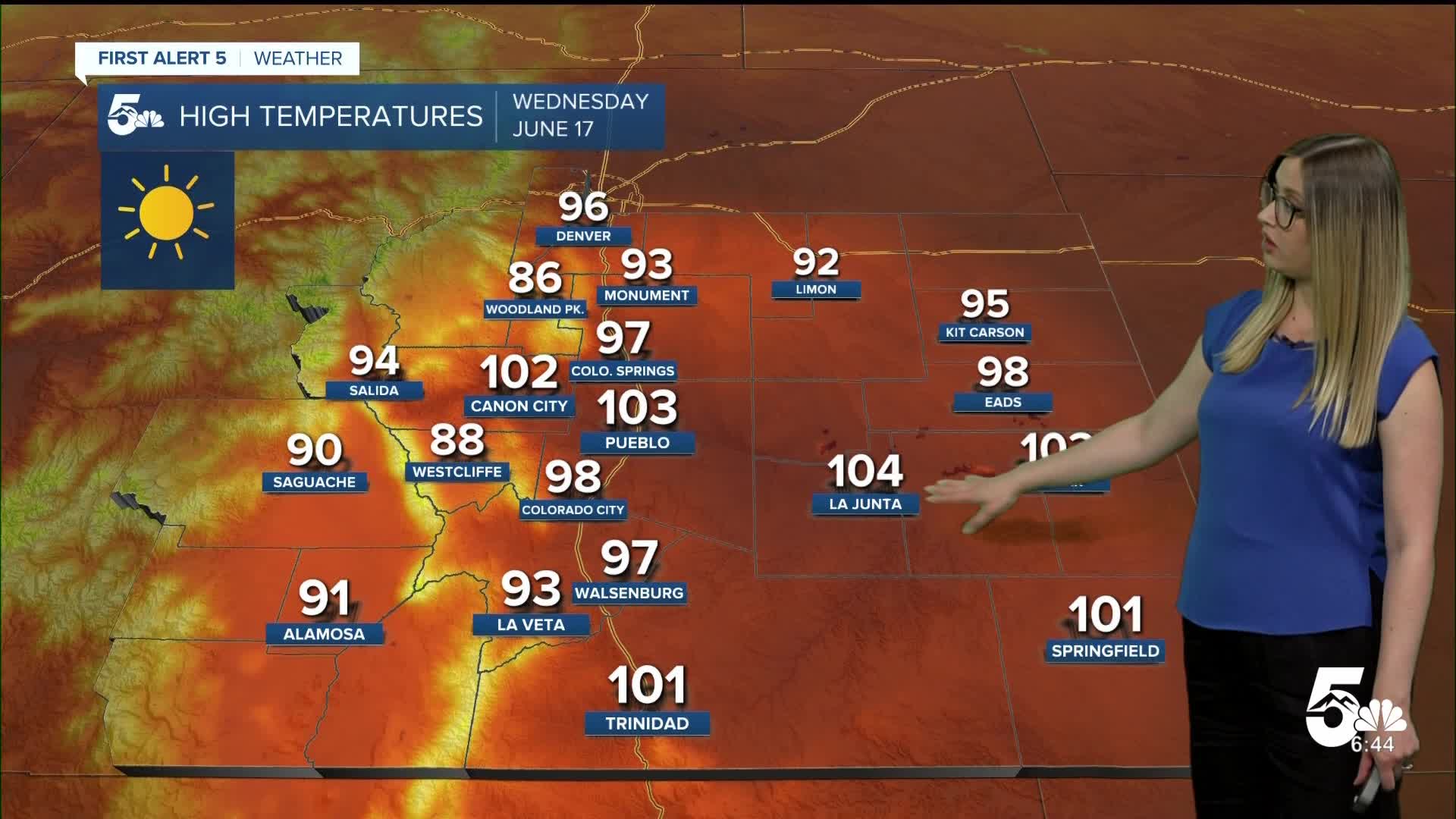
Wednesday heat and fire danger:
For the first time this year, HEAT ADVISORIES have been issued in our region. They are in effect from 11 am until 7 pm for El Paso, Pueblo, and eastern Fremont County. The risk of heat-related illness will be higher during this time.

In addition to the heat, it will also be dry and gusty with high fire danger. A RED FLAG WARNING is in effect from noon until 9 pm for the zones highlighted in red.

Colorado Springs forecast: Low: 58; High: 97;
HEAT ADVISORY in effect from 11 am until 7 pm. The daily temperature record for June 17 stands at 97, which is the current forecast. It will be sunny with NW wind at 20 mph gusting to 25 mph.
Pueblo forecast: Low: 60; High: 103;
HEAT ADVISORY in effect from 11 am until 7 pm. RED FLAG WARNING in effect from noon until 9 pm. The current record for June 17 is 103, which is the current forecast high. It will be sunny with WNW wind at 10 mph gusting to 30 mph.
Canon City forecast: Low: 64; High: 102;
HEAT ADVISORY in effect from 11 am until 7 pm. RED FLAG WARNING in effect from noon until 9 pm. It will be sunny with WNW wind at 15 mph gusting to 35 mph.
Woodland Park forecast: Low: 55; High: 86;
RED FLAG WARNING in effect from noon until 9 pm. A sunny and hot day with WNW wind at 15-20 mph gusting to 35 mph.
Tri-Lakes forecast: Low: 57; High: 93;
HEAT ADVISORY in effect from 11 am until 7 pm. It will be sunny and hot with NW wind at 10 mph gusting to 25 mph.
Plains forecast: Low: 50s-60s; High: 90s-100s;
It will be a scorcher on Wednesday with sunny conditions and highs in the mid-90s to 100s. Wind will be out of the NW at 10-15 mph, gusting to 25 mph.
Walsenburg and Trinidad forecast: Low: 63/59; High: 97/101;
RED FLAG WARNING in effect from noon until 9 pm. It will be hot and sunny with NW wind at 10-15 mph, gusting 25-30 mph.
Mountains forecast: Low: 40s-50s; High: 80s-90s;
RED FLAG WARNING in effect from noon until 9 pm. It will be a toasty day with sunshine and gusty wind out of the WNW at 10-20 mph, gusting 30-40 mph.
Extended outlook forecast:
Relief will come quickly with a dry cold front on Thursday, dropping the temperature about 15-20 degrees. Temperatures will start to creep back up on Friday and Saturday with most of the region back to 80s and 90s in no time.
A few isolated thunderstorms are possible on Sunday, with better rain chances coming Monday and Tuesday next week.
____
Curious about the First Alert 5 Weather Storm Impact Scale? Check out our cheatsheet explainer.
Watch KOAA News5 on your time, anytime with our free streaming app available for your Roku, FireTV, AppleTV and Android TV. Just search KOAA News5, download and start watching.
