

Today’s Forecast:
A strong jet stream presence will bring a very active weather day to Colorado on Monday. A High Wind Warning is currently in effect for the southern Sangres and Raton Mesa Region. Gusts on the eastern slopes this morning could top 70 mph in some areas. The warning is set to expire at 9 am.

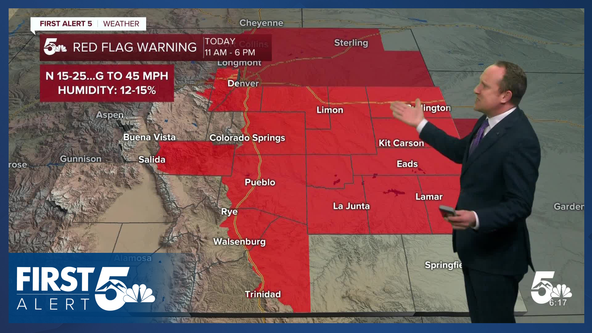
Behind a cold front this morning, northerly winds will increase across the rest of Colorado. This will lower humidity and lead to widespread high fire danger threats. A Red Flag Warning will remain in effect today from 11 am until 6 pm.

Temperatures today will be around 10 degrees cooler than yesterday, but still above average for this time of the year. As the wind dies down this evening, it will be another cold night, with below freezing temperatures for many areas.
Colorado Springs forecast: High: 68; Low: 30. Our mild and breezy morning will give way to a gusty afternoon across the Pikes Peak Region. Wind gusts to 35 mph and humidity in the teens will prompt Red Flag Warnings today from 11 am until 6 pm.
Pueblo forecast: High: 74; Low: 28. Windy and dry weather will make headlines today, prompting the first big Red Flag Warning day of the season for the state. In Pueblo County, a Red Flag Warning will remain in effect today from 11 am until 6 pm.
Canon City forecast: High: 72; Low: 33. A Red Flag Warning will go into effect in Fremont County starting at 11 am. Driven by wind gusts to 40 mph, fire danger threats will remain elevated until early this evening.
Woodland Park forecast: High: 57; Low: 26. Hold onto your hats Teller County because the work week will start out windy and dry. Westerly wind gusts look to peak around 40-45 mph this afternoon before weakening this evening.
Tri-Lakes forecast: High: 60s; Low: 20s/30s. An incoming cold front will bring us a cooler and windy start to the week. Highs today will be around 10 degrees cooler than yesterday, with peak gusts around 35 mph.
Plains forecast: High: 60s/70s; Low: 20s/30s. Most of the Plains today will see Red Flag Warning conditions, with eastern Las Animas and Baca counties not included in today's warnings. Even for areas not under a Red Flag Warning, Monday's forecast will be windy, with peak gusts to 45 mph.
Walsenburg and Trinidad forecast: High: 70s; Low: 30s. A High Wind Warning will expire at 9 am for Huerfano County, with a Red Flag Warning going into effect starting at 11 am today for areas along and east of I-25.
Mountains forecast: High: 50s; Low: 20s. While the northern mountain ranges will continue to see snow this morning, our weather in the Sangres and Wet Mountains will be dry and very windy on Monday. The worst of the wind is expected to be behind us by the lunch hour, with afternoon wind gusts around 45 mph.
Extended outlook forecast:
Our weather will calm down considerably in the mid-week period, with Tuesday starting out with below freezing temperatures across Southern Colorado. Our highs on Tuesday will be comfortable, topping out in the 60s.
Wednesday looks slightly warmer, which will be followed by a modest cool down late this week. This modest drop in temperatures will come courtesy of an incoming disturbance coming out of California. While not much moisture is associated with this storm, we are looking at some potential showers from Thursday afternoon into Friday morning. Snow levels will drop as low as 9,000 by Friday morning.
____
Curious about the First Alert 5 Weather Storm Impact Scale? Check out our cheatsheet explainer.
Watch KOAA News5 on your time, anytime with our free streaming app available for your Roku, FireTV, AppleTV and Android TV. Just search KOAA News5, download and start watching.
