

Today’s Forecast:
Chinook winds bring the downslope warmth and fire danger back to Southern Colorado on Thursday. Highs today will warm into the 70s in the Pikes Peak Region and 80s in the southeastern Plains.
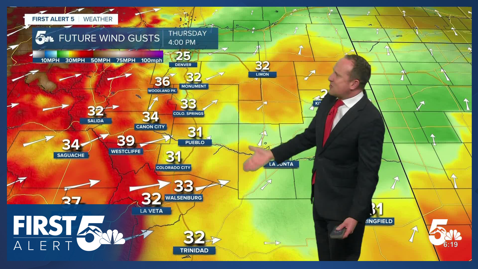
An upper level trough is approaching from the northwest this morning, while high pressure moves southeast. Two pieces of the jet stream will merge together over Colorado this afternoon, which will then help to strengthen mid-level winds, which then increase wind gusts near the ground.
Red Flag Warnings will be in effect from 11:00 AM to 11:00 PM. Winds will be southwesterly, sustained at 15-30 mph, gusting from 35-45 mph in the lower elevations. Peak gusts today in the mountains could top 60 mph.

Colorado Springs forecast: High: 74; Low: 38. Highs today will warm significantly compared to yesterday, topping out in the middle 70s. Today's warm-up will be a direct result of strengthening downslope winds, with peak gusts today up around 30-40 mph.
Pueblo forecast: High: 81; Low: 40. After a calmer day on Wednesday, the wind will ramp up today in advance of our next storm. Peak gusts today could top 40 mph, and a Red Flag Warning will remain in effect from 11 am to 11 pm.
Canon City forecast: High: 78; Low: 42. Warm, dry and windy on Thursday, with a Red Flag Warning in effect from 11 am to 11 pm for all of Fremont County and the upper Arkansas River Valley.
Woodland Park forecast: High: 63; Low: 30. A Red Flag Warning will go into effect today at 11 am, and won't expire this evening until 11 pm. Peak gusts in Teller County could top 45 mph in some areas this afternoon.
Tri-Lakes forecast: High: 60s/70s; Low: 30s. Fire danger will rise on Thursday, driven by gusty downsloping wind and very dry air. A Red Flag Warning will remain in effect today from 11 am to 11 pm.
Plains forecast: High: 70s/80s; Low: 40s. Skies will be bright and our temperatures warm on Thursday, topping out in the 80s in many areas. It will also be windy today, with a Red Flag Warning in effect today from 11 am to 11 pm.
Walsenburg and Trinidad forecast: High: 70s; Low: 30s/40s. Our forecast on Thursday will be warm and windy, with a Red Flag Warning in effect from 11 am to 11 pm. Peak gusts today could top 45 mph.
Mountains forecast: High: 50s/60S; Low: 20s/30s. Much like the rest of Southern Colorado, the southeastern mountains will see high fire danger threats on Thursday. Driven by wind gusts up to 60 mph and dry air, a Red Flag Warning will remain in effect today from 11 am to 11 pm.
Extended outlook forecast:
A cold front will arrive by daybreak on Friday associated with the northern upper level low, bringing in clouds, followed by rain and snow showers arriving by lunchtime. Snow levels will start high at around 6,500 feet, dropping as low as 3,500 feet by the time the storm wraps up late Friday night or early Saturday morning. A secondary frontal boundary pushes through during the afternoon which will provide additional lift and upslope, as well as gusty winds.
You can expect 0-2" of snow in Colorado Springs, 1-3" is possible over the Palmer Divide: in Monument, at the Air Force Academy, and in Black Forest. A similar amount is possible in Woodland Park. Amounts will drop significantly for areas south of Colorado Springs. Only a light dusting is possible in Pueblo, with up to 0.5" in Canon City from the storm.

It will get cold following these frontal systems. We'll drop down to around 20 degrees on Friday night in Colorado Springs, the coldest low in April so far, and the coldest we've been since March 16th. A Freeze Watch has been issued from 12:00 AM - 8:00 AM Saturday.

Saturday remains brisk with post-frontal air in place and highs in the 50s and 60s on the Plains. Another region-wide freeze is likely Saturday night.
We'll warm back up by Sunday with downslope wind returning. The warning trend continues into the first half of next week.
____
Curious about the First Alert 5 Weather Storm Impact Scale? Check out our cheatsheet explainer.
Watch KOAA News5 on your time, anytime with our free streaming app available for your Roku, FireTV, AppleTV and Android TV. Just search KOAA News5, download and start watching.
