



COLORADO SPRINGS, Colo. (KOAA) — Today’s Forecast:
A Flash Flood Emergency was issued Tuesday for a portion of the Aspen Acres burn scar due to a very heavy thunderstorm that tracked over the northern half of the fire. Many other Severe Thunderstorm Warnings, and Flash Flood Warnings, were issued in southern Colorado.
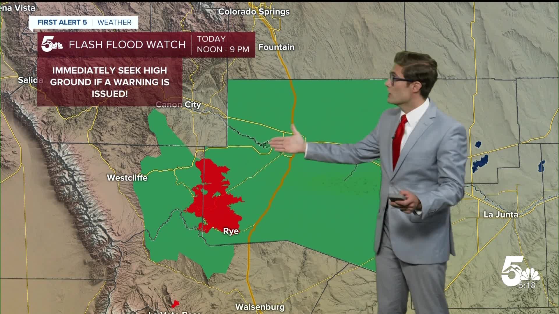
Today, severe threats will be lower, but flood threats will be the same, or in some cases higher. A Flood Watch has been issued for the southern I-25 corridor and portions of the eastern plains, from 12-9 PM today. In addition, a Flash Flood Watch has been issued for the Aspen Acres burn scar for the same time frame. In both cases, rapid flooding is possible. In the burn scar zones, this flooding may once again be significant if heavy thunderstorms roll over the fire - with debris flows possible. Heavy rain has saturated the ground and made flooding easier.
Never drive through flooded roadways. One foot of fast-moving water is all it takes to sweep your car off the road.
Storm timing today will be a bit later than yesterday, with more action in the middle to late afternoon.
Regardless: have multiple ways to receive weather warnings today, know where high ground is relative to your location, and be prepared to move there if a Flash Flood Warning is issued for your area. Severe threats today should be lower.
Highs today will be cooler than the last few days, near average and seasonally hot.
Colorado Springs forecast: High: 87; Low: 60.
FLOOD WATCH in effect from 12:00 PM - 9:00 PM
Mostly sunny this morning with periodic clouds becoming partly cloudy by the afternoon. Scattered afternoon thunderstorms with slightly less overall coverage compared to Tuesday. Storms remain capable of producing heavy rainfall and are most likely in the mid to late afternoon. Do not drive through flooded roadways.
Pueblo forecast: High: 92; Low: 62.
FLOOD WATCH in effect from 12:00 PM - 9:00 PM
FLASH FLOOD WATCH for the Aspen Acres burn scar in effect from 12:00 PM - 9:00 PM
Mostly sunny this morning. Storms will be isolated in the early afternoon, with better chances in the mid and late afternoon and once again will be capable of heavy rainfall. Do not drive through flooded roadways. Severe threats are lower today due to lower wind shear.
Canon City forecast: High: 92; Low: 65.
FLOOD WATCH in effect from 12:00 PM - 9:00 PM
Mostly sunny this morning, with scattered afternoon thunderstorms. Storms will be capable of producing heavy rainfall and frequent lightning.
Woodland Park forecast: High: 80; Low: 53.
FLOOD WATCH in effect from 12:00 PM - 9:00 PM
Mostly sunny this morning, partly cloudy by noon. Storms are still highly likely today, but should form a bit later than yesterday and will favor the mid to late afternoon hours.
Tri-Lakes forecast: High: 80s; Low: 50s.
FLOOD WATCH in effect from 12:00 PM - 9:00 PM
Mostly sunny this morning, with scattered generally non-severe PM thunderstorms. Like yesterday, more than one round of rain is possible, and storms will be capable of dumping very heavy rain. Lower concerns today for large hail or damaging wind, though a few cells remain likely to produce some level of gusty wind too. Do not drive through flooded roadways!
Plains forecast: High: 90s; Low: 60s.
FLOOD WATCH in effect from 12:00 PM - 9:00 PM for Otero, Crowley, and Kiowa counties
Mostly sunny for a good portion of the day, and still quite humid by Colorado standards with dew points well into the 60s. Isolated storms are possible from late afternoon, through about midnight and will be once again capable of dumping heavy rain.
Walsenburg and Trinidad forecast: High: 91/95; Low: 62/63.
FLOOD WATCH in effect from 12:00 PM - 9:00 PM
Mostly sunny this morning, with thunderstorms this afternoon. They should form fairly early again today, by noon over the Culebra Range, and then progress eastward toward the Raton Mesa over the next few hours. Storms will be capable of heavy rain, and frequent lightning.
Mountains forecast: High: 80s; Low: 50s.
FLASH FLOOD WATCH for the Aspen Acres burn scar in effect from 12:00 PM - 9:00 PM
Mostly sunny this morning, with widespread thunderstorms this afternoon. The earliest storms form over the highest summits between 11AM - 12PM. Storms become more numerous from 12-3 PM. Additional rounds of storms remain possible through the early evening. Flash flooding is possible. Seek high ground if a warning is issued for your area.
Extended outlook forecast:
We begin to slowly dry out over the next two days. Our sub-tropical ridge will slide west, which will place Colorado into more of a west to northwest flow pattern, and that should pull in much drier mid-level air. We'll see scattered thunderstorms Thursday, still a somewhat active day, then isolated storms Friday, and dry and hot conditions this weekend. We'll be back to the 90s on much of the plains Thursday and Friday, and it will be roasting again this weekend.
Moisture will begin to return early next week, but the full monsoonal plume may take a bit longer to really return to eastern Colorado.
____
Curious about the First Alert 5 Weather Storm Impact Scale? Check out our cheatsheet explainer.
Watch KOAA News5 on your time, anytime with our free streaming app available for your Roku, FireTV, AppleTV and Android TV. Just search KOAA News5, download and start watching.
____
Curious about the First Alert 5 Weather Storm Impact Scale? Check out our cheatsheet explainer.
Watch KOAA News5 on your time, anytime with our free streaming app available for your Roku, FireTV, AppleTV and Android TV. Just search KOAA News5, download and start watching.
