

Today’s Forecast:
Colorado remains under the influence of an enhanced jet stream due to a stubborn high in the central US that is blocking a low over the Pacific Northwest. That low is leading to unusual Winter Storm Warnings for some of the mountains in Montana — while here in Colorado, we're dealing with the heat and wind from this classic wind-maker combination.
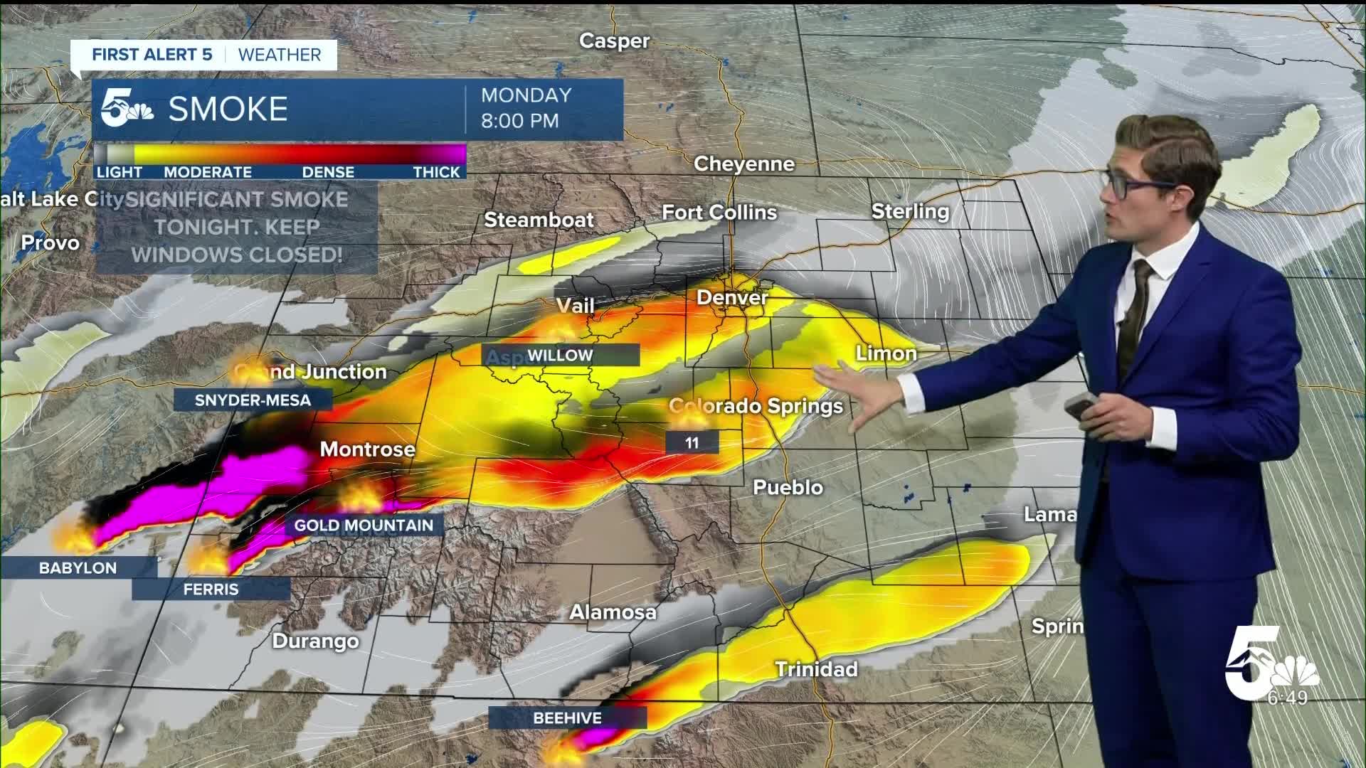
Earlier this spring, we talked extensively about how our lack of statewide snowpack could prime us for a dangerous fire season. We're now seeing that play out. While parts of the plains saw decent rainfall last week, that rain didn't really make a dent in the mountain zones - much of which remain in severe to exceptional drought conditions. This tinderbox has been waiting for meteorological conditions to deteriorate, and they have. Several large wildfires are burning across the western slope, along with a fire in Fremont County. There is now another new fire burning in Custer County.
These fires are producing smoke that will impact you today in southern Colorado. You'll see some this morning. It will dissipate later this morning, and then thicken up again tonight. I'd suggest keeping your windows closed this evening. It is hot, but this smoke can be bad for your health when it gets thick. Generally when visibility from smoke drops to 5 miles or less, that is when you should be avoiding keeping the windows open.
Temperatures are warm out the door in the 70s, and we'll warm to the 90s and triple digits today - a little cooler than Sunday but still HOT! It will be gusty with west southwest winds. Please continue to avoid outdoor burning, and be extra mindful of activities that produce sparks.
Colorado Springs forecast: High: 90; Low: 56.
RED FLAG WARNING in effect from 10:00 AM - 10:00 PM
Another hot, sunny, and gusty day - with highs down a few ticks from Sunday. Expect periods of smoke throughout the day, and patchy blowing dust too. Southwest winds at 10-20 mph this morning, and 15-25 mph this afternoon, gusting to 40 mph at times. Wildfire smoke is likely to move in this evening from fires burning across the west.
Pueblo forecast: High: 97; Low: 59.
RED FLAG WARNING in effect from 10:00 AM - 10:00 PM
Windy, again, today - with high fire danger. Smoke from the Aspen Acres fire will impact your air quality this morning. Keep windows closed if visibility in your neighborhood drops under 5 miles. Southwest winds at 10-30 mph, gusting to 45 mph. Very hot!
Canon City forecast: High: 93; Low: 59.
RED FLAG WARNING in effect from 10:00 AM - 10:00 PM
Hot, windy, and dry once again - continue to avoid outdoor burning! You'll also notice periodic wildfire smoke from a mixture of local fires, and fires burning across western Colorado into central Utah. Southwest winds at 10-30 mph, gusting to 45 mph.
Woodland Park forecast: High: 77; Low: 48.
RED FLAG WARNING in effect from 10:00 AM - 10:00 PM
High fire danger - windy, dry and warm. Southwest winds at 15-25 mph, gusting to 50 mph! The strongest gusts will be before 12 PM.
Tri-Lakes forecast: High: 80s; Low: 50s.
Patchy smoke, and very warm. Southwest winds at 15-25 mph, gusting to 40 mph.
Plains forecast: High: 90s/100s; Low: 60s.
Yet again, very hot - roasting in the heat of summer. Southwest winds at 10-30 mph...it will feel like a hairdryer this afternoon and tonight.
Walsenburg and Trinidad forecast: High: 90/94; Low: 57/58.
RED FLAG WARNING in effect until 10:00 PM
Hot, with patchy smoke and patchy blowing dust. Southwest winds at 10-30 mph gusting to 50 mph.
Mountains forecast: High: 70s; Low: 50s.
RED FLAG WARNING in effect from 10:00 AM - 10:00 PM
Smoke, and strong winds, are the main themes today - with continued high fire danger. Any fires that start will grow quickly, as you have already seen. West winds at 15-30 mph, gusting to 50-65 mph. The strongest winds will be before 12 PM. If you haven't already done so, make sure your family is up to date on your evacuation plan. Where would you meet, what are two different routes out of your neighborhood, what are your essential documents, medicines, and what supplies do you need for your pets? Know that now - so that you're prepared, if needed.
Extended outlook forecast:
Continued gusty, hot conditions will be with us through the middle of the week with daily downslope breezes, and highs consistently in the upper 80s to low 90s. We'll see a warming trend late in the week with mid-90s by Friday. An early preview for your July 4th weekend keeps us hot, with highs in the low 90s in the Pikes Peak Region, to triple digits in Pueblo, and plenty of sunshine. By Sunday, we will begin to see at the least an increase in clouds, and potentially some mountain shower chances return.
____
Curious about the First Alert 5 Weather Storm Impact Scale? Check out our cheatsheet explainer.
Watch KOAA News5 on your time, anytime with our free streaming app available for your Roku, FireTV, AppleTV and Android TV. Just search KOAA News5, download and start watching.
