

Today’s Forecast:
Fire danger will be high again in Southern Colorado, as a large grass fire burns in the southeastern section of El Paso County. The Hammer Fire was driven yesterday by strong southwesterly wind and low single digit relative humidity values. Critically dry fuels, coupled with gusty wind, allowed for explosive fire growth.
This morning, a cold front is pushing into the region resulting in a northerly wind shift. Humidity has remained low overnight, but wind has temporarily relaxed a bit near the fire. Unfortunately, this will be short lived.
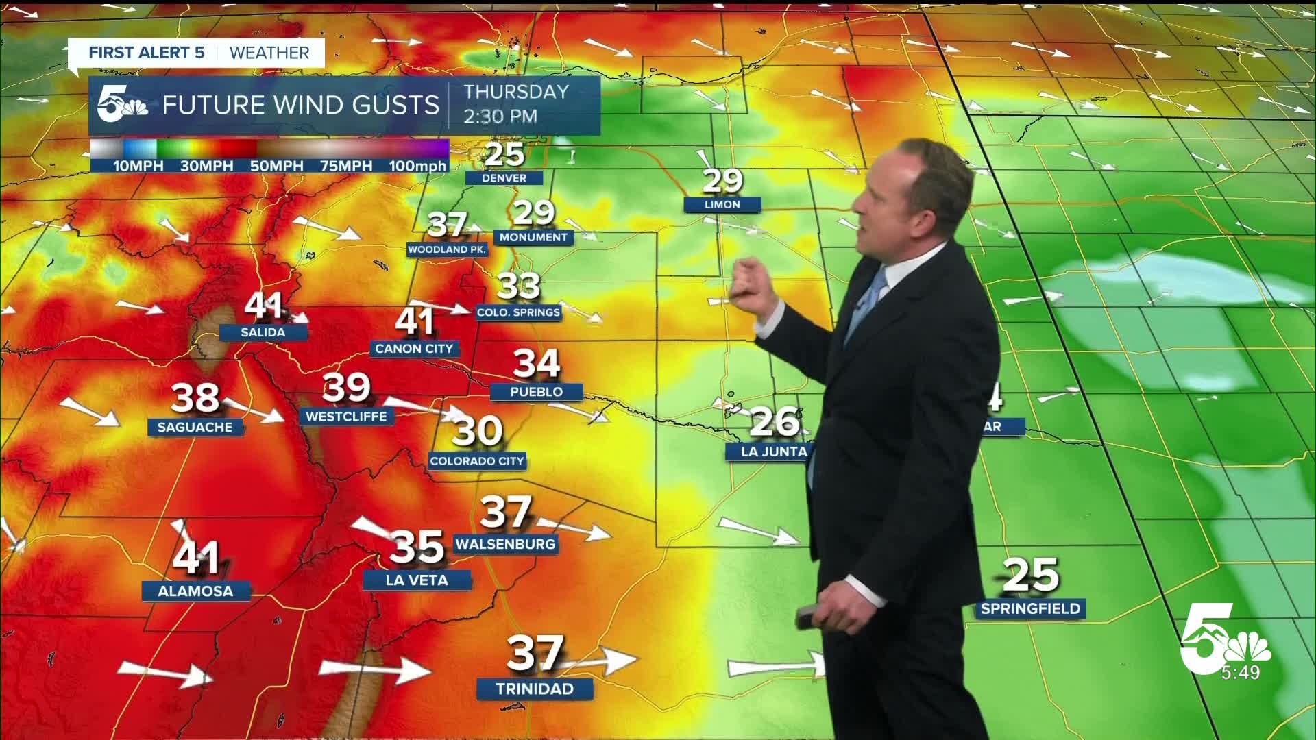
Later this morning, we'll see a west-northwest wind build. West of I-25, the wind is already strong this morning with 40-60 mph gusts in the Front Range mountains.
Red Flag Warnings will be in place from 11:00 AM - 9:00 PM, driven by a system tracking well to our north. That's why our wind direction is northwesterly today. You can expect sustained winds this afternoon of 15-30 mph. Highs today across Southern Colorado will be around 10-15 degrees cooler than yesterday.
Colorado Springs forecast: High: 65; Low: 35. It has remained breezy to gusty this morning, especially into western parts of El Paso County, where gusts have been in the 30-45 mph range early this morning. After a brief lull in the wind later this morning, the wind will increase this afternoon, dropping humidity back down to the single digits. A Red Flag Warning will remain in effect today from 11 AM to 9 PM.
Pueblo forecast: High: 73; Low: 33. A cold front this morning will shave off around 15 degrees to our highs today, topping out in the upper 70s. Unfortunately, moisture is lacking with the front and instead of rain on Thursday, we'll see a return of Red Flag Warnings, in effect from 11 AM to 9 PM.
Canon City forecast: High: 70; Low: 37. Back to back Red Flag Warnings are in store for Canon City late this week, with a Red Flag Warning in effect today from 11 AM to 9 PM. Peak gusts this afternoon will be around 35-45 mph.
Woodland Park forecast: High: 56; Low: 38. We'll be back under a Weather Alert today, with a Red Flag Warning in effect today from 11 AM to 9 PM. Peak gusts this afternoon could top 50 mph in parts of Teller County.
Tri-Lakes forecast: High: 50s/60s; Low: 30s. It's deja vu from yesterday, with another warm and windy day ahead for northern El Paso County. The main difference today compared to yesterday will be cooler highs, only topping out in the upper 50s and 60s.
Plains forecast: High: 70s; Low: 30s. Highs today will be cooler than the past two days as we swap out 80s and 90s for 70s. Unfortunately, we'll continue to see a repeat of dry and windy weather today, with a Red Flag Warning in effect from 11 AM to 9 PM.
Walsenburg and Trinidad forecast: High: 60s/70s; Low: 30s. The southern I-25 corridor will see another dry and windy day, resulting in our second consecutive day under a Red Flag Warning. Peak gusts today could top 40-45 mph in some areas.
Mountains forecast: High: 40s/50s; Low: 20s/30s. We will see another day under a Red Flag Warning in the southeastern mountains. Today's peak gusts will be 45-55 mph. If a fire breaks out in the mountains or mountain valleys today, the strong NW wind could push the fire quickly off to the SE.
Extended outlook forecast:
Wind will be taken down a few more notches tomorrow, but it will still be gusty and dry. Fire Weather Watches are in place from 11:00 AM - 9:00 PM. If converted to warnings, this will mark the 47th day with Red Flag Warnings in Southern Colorado so far this year. Last year's full year total was 49. An average year sees 43 Red Flag Warning days.
Saturday will be breezy again but the wind will be reduced compared to Friday, with a southwesterly flow in the afternoon. A weak front will push south in the morning. Moisture will increase ahead of a large area of low pressure west of Colorado, which will lead to a chance for an isolated afternoon or evening rain shower. Dry low-level air may lead to evaporation with these isolated showers, resulting in additional gusty wind. Highs will be in the 60s and 70s on the Plains.
Showers and thunderstorms become more likely Sunday afternoon as a surface low develops over the southeastern plains. Shower and storm chances are greatest in the northern half of the state, and in the mountains. Mixed precipitation is possible in the higher elevations of Teller County. Highs will be cooler than Saturday by a few degrees. Additional showers and storms are possible Monday, but they look isolated.
In the extended picture, we are hoping for better moisture potential in the second half of next week. Stay tuned...
____
Curious about the First Alert 5 Weather Storm Impact Scale? Check out our cheatsheet explainer.
Watch KOAA News5 on your time, anytime with our free streaming app available for your Roku, FireTV, AppleTV and Android TV. Just search KOAA News5, download and start watching.
