

Today’s Forecast:
Strong upper level winds - known as a jet streak - lead to a combination of high wind, fire danger, and even a brief shot of rain and snow today. An elevated cold front is racing east this morning and is crossing through the Pikes Peak Region. Behind it, moisture will increase leading to a snow squall chance between 7-9 AM. Teller County and the Palmer Divide are the most likely places to see impacts with this precipitation. While snow accumulations aren't a big headline, visibility and travel impacts are. Visibility will drop as this quick line of rain and snow moves through. This line may hold together into Colorado Springs itself, but some of the moisture is likely to evaporate above ground, producing even more wind.
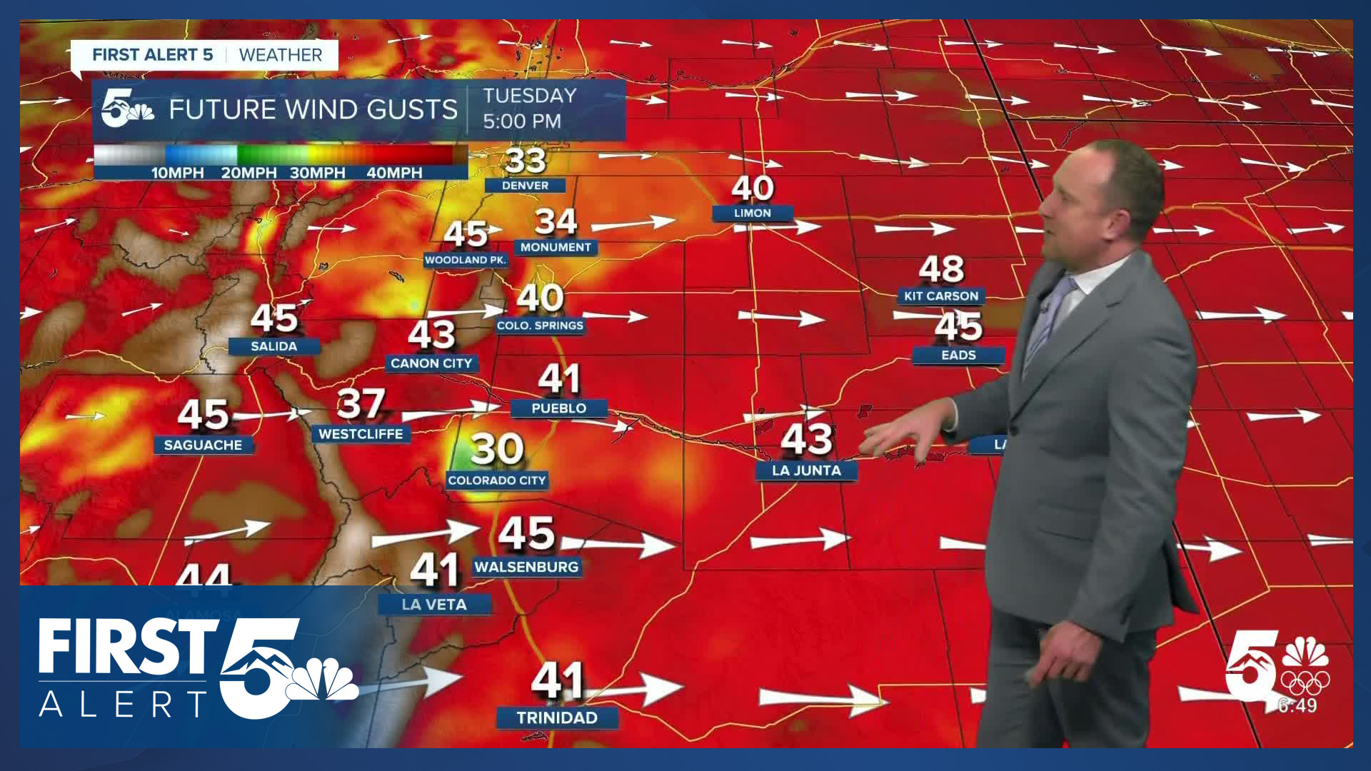
Even if we get a small amount of moisture from this line, it won't help our fire danger. It will be very high today. This is a high-end fire setup for Southern Colorado. West, southwest winds will increase through the morning. Expect sustained winds of 30-40 mph today, gusting 40-55 mph in Colorado Springs, and 60-70 mph along and southeast of Highway 50. Even stronger wind is likely in the Sangre de Cristos and Wet Mountains.

The blend of strong winds, and very dry fuels, means if a fire begins today, it will spread quickly and grow erratically. If you see smoke today, call 911. Do not assume emergency services already know about the fire. The faster emergency crews can respond, the better their chance of protecting life and property.

Similarly - avoid activities that could start a wildfire today. El Paso County is under stage 2 fire restrictions.
In the mountains, significant snow has begun, and this is wind-driven. Expect extremely challenging mountain travel conditions, and road closures are likely.
Colorado Springs forecast: High: 54; Low: 28. A High Wind Warning will remain in effect today until 2 pm, and a Red Flag Warning from 10 am until 7 pm. Peak gusts of 45-60 mph can be expected today, with the the strongest gusts in the foothills. This morning, a quick moving front could bring some wind driven showers to the Pikes Peak Region between 7-9 am.
Pueblo forecast: High: 62; Low: 27. Tuesday's forecast will be very windy and very dry, with both a High Wind Warning and Red Flag Warning in effect through early this evening. Gusts in Pueblo today could top 50-60 mph. Stay vigilant and avoid outdoor burning.
Canon City forecast: High: 58; Low: 30. While Fremont County will see High Wing Warnings today from 7 am until 6 pm, we will not be included in today's Red Flag Warnings. This is due to higher humidity than surrounding areas.
Woodland Park forecast: High: 50; Low: 21. Teller County will not be under today's Red Flag Warning, but it will be very windy. That is due to humidity values higher than 15%. Peak wind gusts here could top 50-60 mph through late this afternoon. This morning, a quick moving cold front will bring a chance for intense, but brief snow showers.
Tri-Lakes forecast: High: 40s; Low: 20s. Windy and dry, with a Red Flag Warning in effect from 10 am until 7 pm. Peak gusts to 55 mph will follow from late this morning until late this afternoon. A quick moving front that will clear the Palmer Divide before 9 am could also bring a quick shot of intense snow, with poor visibility a possibility if we see any snow.
Plains forecast: High: 60s/70s; Low: 20s/30s. A High Wind Warning will remain in effect until 6 pm, with a Red Flag Warning in effect until 7 pm. The strongest gusts today could top 65 mph.
Walsenburg and Trinidad forecast: High: 40s/50s; Low: 20s/30s. Both a High Wind Warning (until 6 pm) and Red Flag Warning (until 7 pm) have been issued for the southern I-25 corridor on Tuesday. Gusts in wind prone spots could surpass 60 mph. Secure outdoor items that could easily fly away and avoid outdoor burning.
Mountains forecast: High: 30s/40s; Low: 10s/20s. High Wind Warnings (until 6 pm) and Winter Weather Advisories (until 2 pm) have been issued for the mountains on Tuesday. Peak gusts to 80 mph will be possible above treeline. Below treeline, 60-70 mph gusts will be possible. Up to 6" of snow is possible today in the Sangres, with 1-3" for the Wets.
Extended outlook forecast:
It will remain windy on Wednesday, but the winds won't be as strong as today. Winds will be sustained at 20-30 mph in the afternoon, gusting 30-50 mph in the Pikes Peak Region. Humidity values will be a limiting factor for fire danger, but it will still be elevated, with critical fire danger further south and east. It will once again be mild with highs in the low 50s.
The next cold front will arrive on Thursday, and it will be significantly cooler with highs only in the lower 40s. Fire danger remains high, with weaker winds but drier air.
On Friday, there is a slight chance of snow showers in the Pikes Peak Region as another system moves east out of the mountains. Overall precipitation chances do not look impressive at the moment.
____
Curious about the First Alert 5 Weather Storm Impact Scale? Check out our cheatsheet explainer.
Watch KOAA News5 on your time, anytime with our free streaming app available for your Roku, FireTV, AppleTV and Android TV. Just search KOAA News5, download and start watching.
