

Today’s Forecast:
After rain, thunderstorms, hail and even snow yesterday in the Pikes Peak Region, Tuesday will be a bit calmer. The latest disturbance to move into Colorado this afternoon will only skirt our area, with a small chance of a shower in the Pikes Peak Region. Most of the rain and snow today will fall in the mountains and northern Colorado.
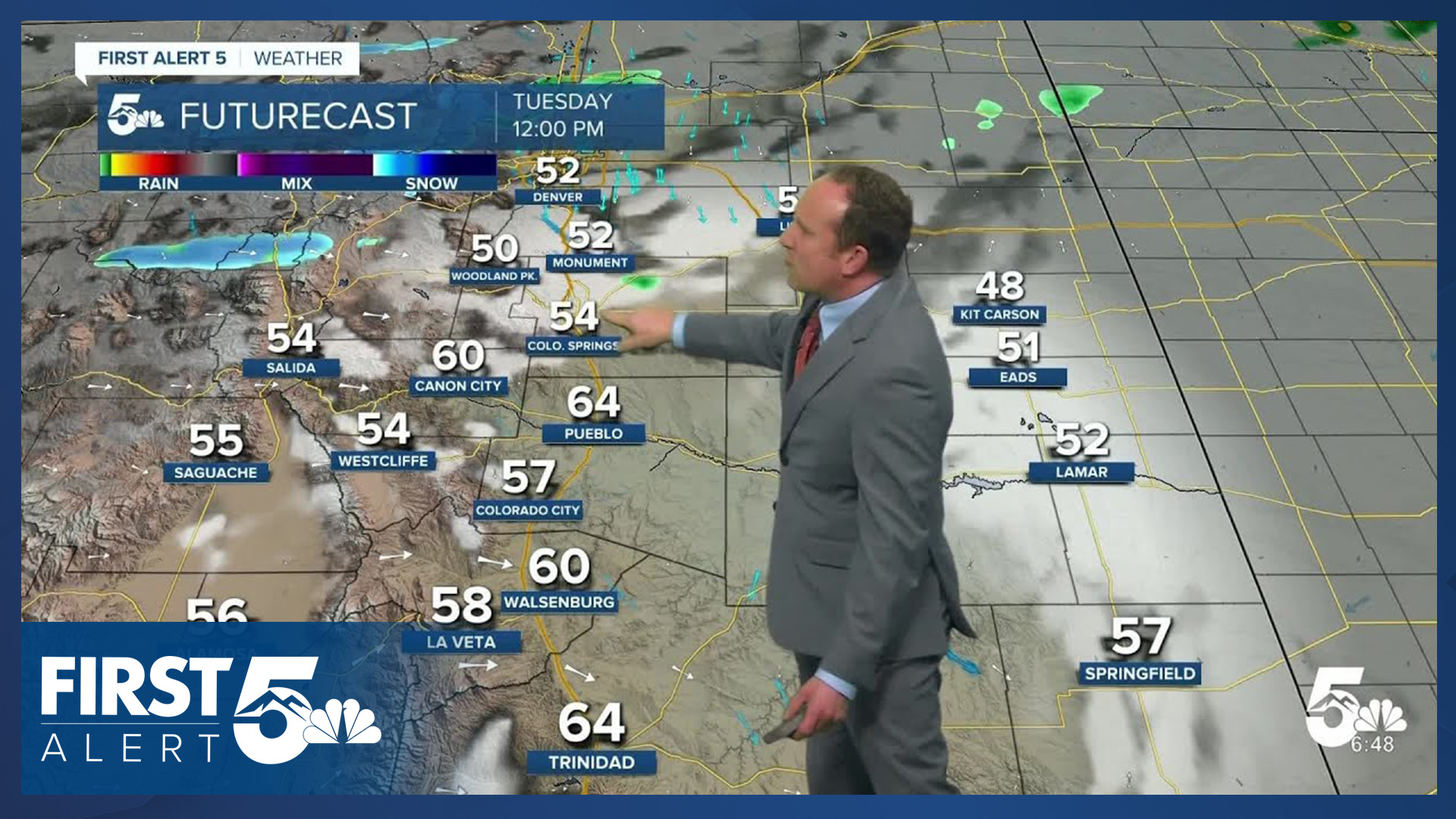
Highs today will be similar to slightly warmer than yesterday, warming into the 50s, 60s and lower 70s.
Also of note, a Red Flag Warning has been issued today from noon to 7 pm for the San Luis Valley.
Colorado Springs forecast: High: 60; Low: 36. After thunderstorms, rain and hail on Monday, today's forecast will be quieter. Cloudy skies and areas of fog this morning will give way to a few sunbreaks this afternoon and only a few isolated showers. Rain chances today will be the lowest of the week, at around 30%.
Pueblo forecast: High: 70; Low: 38. Dry skies will continue in Pueblo on Tuesday, with our high today expected to come up right near our average high for this time of the year of 70 degrees.
Canon City forecast: High: 68; Low: 40. Near average highs and mainly dry skies can be expected this afternoon in eastern Fremont County. Rain chances today will only hover around 10%.
Woodland Park forecast: High: 54; Low: 27. After rain and snow showers yesterday, today should be a little calmer, with less showers in our forecast on Tuesday. Any additional showers today could bring a risk of lightning to Teller County.
Tri-Lakes forecast: High: 50s; Low: 30s. After a cool, damp and overcast start to our Tuesday, our forecast this afternoon will feature a chance for spotty showers and near average highs. Any showers that do form may bring a small risk of a thunderstorm to northern El Paso County.
Plains forecast: High: 60s/70s; Low: 30s. Most of the southeastern Plains will stay dry on Tuesday ahead of some much needed moisture in the mid to late week period, with only a small chance of a shower today for areas north of Highway 50.
Walsenburg and Trinidad forecast: High: 60s/70s; Low: 30s. A sunny, mild and breezy day can be expected on Tuesday across the southern I-25 corridor, with today's weather almost a mirror image of what we saw on Monday.
Mountains forecast: High: 40s/50s; Low: 20s. Tuesday's forecast will be mainly dry and breezy to gusty. Westerly wind gusts this afternoon will top out at around 35 mph.
Extended outlook forecast:
Rain chances will increase on Wednesday, leading to improving chances for showers and thunderstorms by the afternoon. Highs on Wednesday will cool back down to the upper 50s in Colorado Springs. Additional rain showers are likely from Wednesday night into Thursday morning.
By Thursday, our well-advertised spring soaker arrives. Any outdoor plans should be put on hold as widespread rain and high elevation snow will bring us wet and unsettled conditions for most of the day. Highs on Thursday will only warm into the middle 40s in Colorado Springs.
The main question with the incoming storm is how low does the snow fall? Right now, we see the potential for a changeover to snow Thursday night into Friday morning for areas between 6,500 and 7,000 feet. However, I think that most accumulations and impacts will be above 7,000 feet. By Friday morning, heavy snowfall and impacts to travel are expected in Teller County, and very likely over Monument Hill. Skies will dry out by Friday evening as a warming trend follows this weekend.
____
Curious about the First Alert 5 Weather Storm Impact Scale? Check out our cheatsheet explainer.
Watch KOAA News5 on your time, anytime with our free streaming app available for your Roku, FireTV, AppleTV and Android TV. Just search KOAA News5, download and start watching.
