


Today’s Forecast:
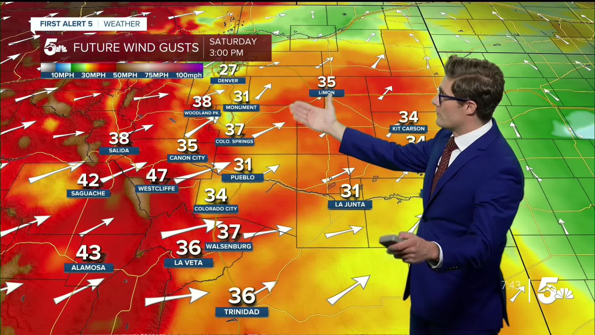
It's going to be HOT HOT HOT this weekend in southern Colorado as the jet stream ramps up across the state. High pressure to the southeast, and low pressure to the northwest both combine to ramp up the wind speeds which mix down along the Front Range heading into the afternoon. Red Flag Warnings are in effect for essentially all areas west of I-25 today. In the mountains, wind gusts of 50-55 mph are possible. Humidity will drop to 5-15% this afternoon.
Today's temperatures will be in the 90s to triple digits, so remember to drink plenty of water if you'll be spending a lot of time outside. You're already starting to become dehydrated when you feel thirsty.
If you're headed to Cripple Creek for Donkey Derby Days, expect gusty conditions with highs in the middle 70s.
Colorado Springs forecast: High: 90; Low: 61.
Hot and gusty today in the Pikes Peak Region. You can expect 30-40 mph gusts today out of the southwest, with sustained winds at 20-25 mph. Plenty of potent sunshine too, plan accordingly.
Pueblo forecast: High: 97; Low: 62.
Very hot - and very dry. A few high clouds at times but overall mostly sunny and windy. Gusts of 30-40 mph this afternoon out of the west southwest, sustained winds at 15-25 mph.
Canon City forecast: High: 93; Low: 61.
RED FLAG WARNING in effect from 11:00 AM - 12:00 AM SUN
Hot, dry, sunny, and windy today. West winds at 10-15 mph, shifting southwest at 15-30 mph this afternoon and gusting to 40 mph at times.
Woodland Park forecast: High: 80; Low: 50.
RED FLAG WARNING in effect from 11:00 AM - 12:00 AM SUN
Sunny and very warm with southwest winds at 10-20 mph this morning, increasing to 20-30 mph this afternoon. Gusts of 40-45 mph are possible this afternoon.
Tri-Lakes forecast: High: 80s; Low: 50s.
Gusty today with a dry downslope wind and only a few high clouds. Southwest winds at 10-15 mph this morning, increasing to 20-30 mph this afternoon.
Plains forecast: High: 90s/100s; Low: 60s.
Sunny and very hot! Remember to stay hydrated. Southwest winds at 10-15 mph ramping up to 15-25 mph in the afternoon. If your area didn't get much rain this week, be extremely careful with any outdoor burning.
Walsenburg and Trinidad forecast: High: 90/92; Low: 62/61.
Sunny, windy, and hot. West winds at 15-30 mph, gusting to 45 mph this afternoon.
Mountains forecast: High: 80s; Low: 50s.
RED FLAG WARNING in effect from 11:00 AM - 12:00 AM SUN
Very windy today! Southwest winds at 10-25 mph this morning, and 20-35 mph this afternoon. Gusts to 55 mph this afternoon. Avoid outdoor burning, and any other activity that could spark a wildfire.
Extended outlook forecast:
It will remain modestly breezy this evening, with a few high and mid-level clouds at times. You'll also see some light haze from wildfire smoke due to large fires burning in Utah and Arizona. The smoke doesn't look like it'll be particularly thick and air quality won't be impacted, but it will lead to a vibrant sunset this evening. It's also a good reminder of why it's important to avoid outdoor burning this weekend and be mindful of activities that could generate a spark.
The breeze keeps temperatures mild - with lows only dropping to the low 60s tonight.
We do this all again on Sunday, with temperatures climbing to the low 90s under mainly sunny skies. Wind speeds and gusts look similar, although there may be a bit more concentration in gap zones for the most enhanced winds. Ultimately it will feel like a hairdryer both days. Fire weather watches are posted for Fremont and Teller counties among others, which are likely to be upgraded to Red Flag Warnings this afternoon.
The pattern is going to be very stubborn for the next several days. It stays gusty Monday and Tuesday. We do get a weak cold front on Monday - which grazes the area. It may provide some minor "cooling", but not much. We stay hot with mainly 90s highs through almost all of next week.
____
Curious about the First Alert 5 Weather Storm Impact Scale? Check out our cheatsheet explainer.
Watch KOAA News5 on your time, anytime with our free streaming app available for your Roku, FireTV, AppleTV and Android TV. Just search KOAA News5, download and start watching.
