

Today’s Forecast:
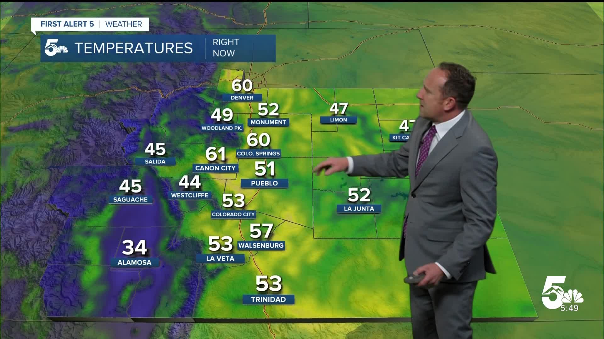
Yesterday's warmth has carried over into this morning, with many areas waking up to temperatures in the 50s. High pressure will continue to dominate as it moves towards Colorado today from Arizona. In spite of an early morning cold front, highs may warm another degree or two from yesterday. Temperatures will top out in the 70s and 80s across Southern Colorado.
Behind the front this morning, we will see breezy to gusty north and northeast winds. The winds will shift out of the southeast by the afternoon and will weaken. Skies will turn partly to mostly cloudy this afternoon, but rain is not expected.
Colorado Springs forecast: High: 81; Low: 49. After upper 70s on Monday, I think that we'll crack the 80 degree mark for the first time this month on Tuesday. Skies will be dry, with breezy to gusty winds, shifting from the NE to SE by the afternoon.
Pueblo forecast: High: 88; Low: 47. Summer-like warmth will continue on Tuesday, with our highs today soaring into the upper 80s. Skies will turn mostly sunny to partly cloudy this afternoon, but rain is not expected in Pueblo.
Canon City forecast: High: 87; Low: 52. Tuesday's forecast will be more like late June than mid May, with well above average highs and partly cloudy skies this afternoon.
Woodland Park forecast: High: 77; Low: 42. Upper 70s in May in Woodland Park is more than 12 degrees above average. Clouds will increase this afternoon, with a few high based showers possible. This would likely result in more wind than any rain drops on Tuesday.
Tri-Lakes forecast: High: 70s; Low: 40s/50s. Sunny and breezy this morning, with increasing clouds and weakening wind towards the late afternoon hours. Any showers that do form today should be high based in nature, which means mostly dry conditions near the surface.
Plains forecast: High: 80s; Low: 40s/50s. Behind a morning cold front will come a period of strong and gusty N/NE winds. Peak gusts through mid afternoon could top 35 mph in some areas. The wind will shift to the SE later today and this evening, with highs in the middle to upper 80s.
Walsenburg and Trinidad forecast: High: 70s/80s; Low: 40s/50s. Tuesday's forecast will be warm and breezy, with rain not likely this afternoon. Gusts to 25 mph will be possible today in Huerfano County.
Mountains forecast: High: 60s/70s; Low: 30s/40s. The southeastern mountains should stay dry on Tuesday, with warm temperatures and partly to mostly cloudy skies this afternoon. A few high based showers could generate some locally gusty winds in and near any developing storms.
Extended outlook forecast:
A slight uptick in moisture on Wednesday will bring a chance for afternoon showers and thunderstorms to areas near the higher terrain and adjacent I-25 corridor, including the Pikes Peak Region. These should be fairly hit or miss in nature. Highs will remain in the 80s on Wednesday.
Rain chances will drop down to 20% on Thursday, with a hot high of 85 degrees in Colorado Springs. Highs on Thursday in Pueblo and Canon City are expected to warm into the lower 90s. Both Friday and Saturday look dry for now ahead of a potential pattern change late this weekend and early next week. Longer range weather models are showing a colder system that dives into Four Corners Region, but exact details still need to be resolved. Right now, we see growing chances for showers and thunderstorms for both Sunday and Monday, and cooler temperatures.
____
Curious about the First Alert 5 Weather Storm Impact Scale? Check out our cheatsheet explainer.
Watch KOAA News5 on your time, anytime with our free streaming app available for your Roku, FireTV, AppleTV and Android TV. Just search KOAA News5, download and start watching.
